

Filters
AMC3 MET.TR.200(a)(12) Meteorological reports and other information
ED Decision 2022/004/R
SUPPLEMENTARY INFORMATION — WIND SHEAR
Information on wind shear should be included as supplementary information in local routine report, local special report, METAR and SPECI, where local circumstances so warrant.
AMC4 MET.TR.200(a)(12) Meteorological reports and other information
ED Decision 2022/004/R
SUPPLEMENTARY INFORMATION — SEA-SURFACE TEMPERATURE AND STATE OF THE SEA
In METAR and SPECI, information on sea-surface temperature and the state of the sea or the significant wave height, from aeronautical meteorological stations established on offshore structures in support of helicopter operations, should be included in the supplementary information.
AMC5 MET.TR.200(a)(12) Meteorological reports and other information
ED Decision 2017/001/R
SUPPLEMENTARY INFORMATION — SIGNIFICANT METEOROLOGICAL CONDITIONS
(a)Observations made at aerodromes should include the available supplementary information concerning significant meteorological conditions, particularly those in the approach and climb-out areas.
(b)Where practicable, the information should identify the location of the meteorological condition.
GM1 MET.TR.200(a)(12) Meteorological reports and other information
ED Decision 2022/004/R
SUPPLEMENTARY INFORMATION — RECENT WEATHER PHENOMENA
‘Recent weather phenomena’ is understood as being the weather phenomena observed at the aerodrome during the period since the last issued routine report or last hour, whichever is the shorter, but not at the time of observation.
GM2 MET.TR.200(a)(12) Meteorological reports and other information
ED Decision 2022/004/R
SUPPLEMENTARY INFORMATION — LOCAL CIRCUMSTANCES
Local circumstances include but are not necessarily limited to wind shear of non-transitory nature such as might be associated with low-level temperature inversions or local topography.
GM3 MET.TR.200(a)(12) Meteorological reports and other information
ED Decision 2022/004/R
SUPPLEMENTARY INFORMATION — WIND SHEAR
The inclusion of wind shear in the supplementary information is understood to be addressed, as a minimum, in local routine report, local special report, METAR and SPECI when reported by a semi-automatic observing system.
GM1 MET.TR.200(b) & (c) Meteorological reports and other information
ED Decision 2022/004/R
EXAMPLE OF METAR AND LOCAL ROUTINE REPORT
(a)Local routine report (same location and weather conditions as METAR): MET REPORT YUDO 221630Z WIND 240/4KT VIS 600M RVR RWY 12 TDZ 1000M MOD DZ FG CLD SCT 1000FT OVC 2000FT T17 DP16 QNH 1018HPA TREND BECMG TL1700 VIS 800M FG BECMG AT1800 VIS 10KM NSW (b)METAR for YUDO (Donlon/International)*: METAR YUDO 221630Z 24004KT 0600 R12/1000U DZ FG SCT010 OVC020 17/16 Q1018 BECMG TL1700 0800 FG BECMG AT 1800 9999 NSW Meaning of both reports: Routine report for Donlon/International* issued on the 22nd of the month at 16.30 UTC; surface wind direction 240 degrees; wind speed 4 knots; visibility (along the runway(s) in the local routine report; prevailing visibility in METAR) 600 metres; runway visual range representative of the touchdown zone for runway 12 is 1 000 metres and the runway visual range values have shown an upward tendency during previous 10 minutes (runway visual range tendency to be included in METAR only); and moderate drizzle and fog; scattered cloud at 1 000 feet; overcast at 2 000 feet; air temperature 17 degrees Celsius; dew-point temperature 16 degrees Celsius; QNH 1 018 hectopascals; TREND during next 2 hours; visibility (along the runway(s) in the local routine report; prevailing visibility in METAR) becoming 800 metres in fog by 17.00 UTC; at 18.00 UTC visibility (along the runway(s) in the local routine report; prevailing visibility in METAR) becoming 10 kilometres or more and nil significant weather. * Fictitious location |
GM1 MET.TR.200(b) Meteorological reports and other information
ED Decision 2022/004/R
EXAMPLE OF SPECI AND LOCAL SPECIAL REPORT
(a) Local special report (same location and weather conditions as SPECI): SPECIAL YUDO 151115Z WIND 050/25KT MAX37 MNM10 VIS 1200M RVR RWY 05 ABV 1800M HVY TSRA CLD BKN CB 500FT T25 DP22 QNH 1008HPA TREND TEMPO TL1200 VIS 600M BECMG AT1200 VIS 8KM NSW NSC (b) SPECI for YUDO (Donlon/International)*: SPECI YUDO 151115Z 05025G37KT 3000 1200NE+TSRA BKN005CB 25/22 Q1008 TEMPO TL1200 0600 BECMG AT1200 8000 NSW NSC Meaning of both reports: Special report for Donlon/International* issued on the 15th of the month at 11.15 UTC; surface wind direction 050 degrees; wind speed 25 knots gusting between 10 and 37 knots (minimum wind speed not to be included in SPECI); visibility 1 200 metres (along the runway(s) in the local special report); prevailing visibility 3 000 metres (in SPECI) with minimum visibility 1 200 metres to north east (directional variations to be included in SPECI only); Runway visual range above 1 800 metres on runway 05 (runway visual range not required in SPECI with prevailing visibility of 3 000 metres); thunderstorm with heavy rain; broken cumulonimbus cloud at 500 feet; air temperature 25 degrees Celsius; dew-point temperature 22 degrees Celsius; QNH 1 008 hectopascals; trend during next 2 hours; visibility (along the runway(s) in the local special report; prevailing visibility in SPECI) temporarily 600 metres from 11.15 to 12.00, becoming at 12.00 UTC visibility (along the runway(s) in the local special report; prevailing visibility in SPECI) 8 kilometres, thunderstorm ceases and nil significant weather and nil significant cloud. * Fictitious location |
AMC1 MET.TR.200(c) Meteorological reports and other information
ED Decision 2022/004/R
METAR AND SPECI — CODE FORM
METAR and SPECI, and corrections thereto, should be encoded using:
(a)the IWXXM GML form as specified in point (a) of AMC1 MET.TR.115(a); and
(b)the alphanumeric code form for METAR as specified in point (b) of AMC1 MET.TR.115(a).
GM1 MET.TR.200(e)(5) Meteorological reports and other information
ED Decision 2020/008/R
NOISE ABATEMENT PROCEDURES
Noise abatement procedures are those in accordance with 7.2.6 of ICAO Doc 4444 ‘Procedures for Air Navigation Services (PANS-ATM)' as last amended.
GM1 MET.TR.200(f) Meteorological reports and other information
ED Decision 2022/004/R
ISSUANCE OF LOCAL SPECIAL REPORTS
Point (f) of MET.TR.200 relates to the list of criteria to provide local special reports and SPECI when a meteorological change occurs. The agreement between the meteorological service provider and the competent authority is introduced as these criteria are usually agreed with the competent authority. Also, in introducing this agreement, the nature of the transposed provision (Appendix 3, 2.3.3 Recommendation) of ICAO Annex 3 remains.
AMC1 MET.TR.200(f)(8) Meteorological reports and other information
ED Decision 2022/004/R
ISSUANCE OF SPECI
Other criteria based on local aerodrome operating minima are to be considered in accordance with point (j) of AMC1 MET.TR.220(f).
MET.TR.205 Reporting of meteorological elements
Regulation (EU) 2021/1338
(a)Surface wind direction and speed
(1)In local routine report, local special report, METAR and SPECI, the surface wind direction and speed shall be reported in steps of 10 degrees true and 1 kt respectively.
(2)Any observed value that does not fit the reporting scale in use shall be rounded to the nearest step in the scale.
(3)In local routine report, local special report, METAR and SPECI:
(i)the units of measurement used for the wind speed shall be indicated;
(ii)variations from the mean wind direction during the past 10 minutes shall be reported as follows, if the total variation is 60° or more, alternatively:
(A)when the total variation is 60° or more and less than 180° and the wind speed is 3 kt or more, such directional variations shall be reported as the two extreme directions between which the surface wind has varied;
(B)when the total variation is 60° or more and less than 180° and the wind speed is less than 3 kt, the wind direction shall be reported as variable with no mean wind direction;
(C)when the total variation is 180° or more, the wind direction shall be reported as variable with no mean wind direction;
(iii)variations from the mean wind speed (gusts), during the past 10 minutes shall be reported when the maximum wind speed exceeds the mean speed by, alternatively:
(A)5 kt or more in local routine report and local special report when noise abatement procedures are applied;
(B)10 kt or more otherwise;
(iv)when a wind speed of less than 1 kt is reported, it shall be indicated as calm;
(v)when a wind speed of 100 kt or more is reported, it shall be indicated to be more than 99 kt;
(vi)when variations from the mean wind speed (gusts) are reported in accordance with point MET.TR.205(a), the maximum value of the wind speed attained shall be reported;
(vii)when the 10-minute period includes a marked discontinuity in the wind direction and/or speed, only variations from the mean wind direction and mean wind speed occurring since the discontinuity shall be reported.
(b)Visibility
(1)In local routine report, local special report, METAR and SPECI, the visibility shall be reported in steps of 50 m when the visibility is less than 800 m; in steps of 100 m when it is 800 m or more, but less than 5 km; in kilometre steps when the visibility is 5 km or more, but less than 10 km; and it shall be given as 10 km when the visibility is 10 km or more, except when the conditions for the use of CAVOK apply.
(2)Any observed value which does not fit the reporting scale in use shall be rounded down to the nearest lower step in the scale.
(3)In local routine report and local special report, visibility along the runway or runways shall be reported together with the units of measurement used to indicate visibility.
(c)Runway visual range (RVR)
(1)In local routine report, local special report, METAR and SPECI, the RVR shall be:
(i)reported throughout periods when either the visibility or the runway visual range is less than 1 500 m;
(ii)reported in steps of 25 m when it is less than 400 m, in steps of 50 m when it is between 400 and 800 m, and in steps of 100 m when it is more than 800 m.
(2)Any observed value which does not fit the reporting scale in use shall be rounded down to the nearest lower step in the scale.
(3)In local routine report, local special report, METAR and SPECI:
(i)when the RVR is above the maximum value that can be determined by the system in use, it shall be reported using the abbreviation ‘ABV’ in local routine report and local special report, and the abbreviation ‘P’ in METAR and SPECI followed by the maximum value that can be determined by the system;
(ii)when the RVR is below the minimum value that can be determined by the system in use, it shall be reported using the abbreviation ‘BLW’ in local routine report and local special report, and the abbreviation ‘M’ in METAR and SPECI, followed by the minimum value that can be determined by the system.
(4)In local routine report and local special report:
(i)the units of measurement used shall be included;
(ii)if the RVR is observed from only one location along the runway, such as the touchdown zone, it shall be included without any indication of location;
(iii)if the RVR is observed from more than one location along the runway, the value representative of the touchdown zone shall be reported first, followed by the values representative of the mid-point and stop-end, and the locations for which these values are representative shall be indicated;
(iv)when there is more than one runway in use, the available RVR values for each runway shall be reported, and the runways to which the values refer shall be indicated.
(d)Present weather phenomena
(1)In local routine report and local special report, observed present weather phenomena shall be reported in terms of type and characteristics and qualified with respect to intensity, as appropriate.
(2)In METAR and SPECI, observed present weather phenomena shall be reported in terms of type and characteristics and qualified with respect to intensity or proximity to the aerodrome, as appropriate.
(3)In local routine report, local special report, METAR and SPECI, the following characteristics of present weather phenomena, as necessary, shall be reported using their respective abbreviations and relevant criteria, as appropriate:
(i)Thunderstorm (TS)
Used to report a thunderstorm with precipitation. When thunder is heard or lightning is detected at the aerodrome during the 10-minute period preceding the time of observation but no precipitation is observed at the aerodrome, the abbreviation ‘TS’ shall be used without qualification.
(ii)Freezing (FZ)
Supercooled water droplets or precipitation, used with types of present weather phenomena in accordance with Appendix 1.
(4)In local routine report, local special report, METAR and SPECI:
(i)one or more, up to a maximum of three, of the present weather abbreviations shall be used, as necessary, together with an indication, where appropriate, of the characteristics and intensity or proximity to the aerodrome, so as to convey a complete description of the present weather of significance to flight operations;
(ii)the indication of intensity or proximity, as appropriate, shall be reported first followed respectively by the characteristics and the type of weather phenomena;
(iii)where two different types of weather are observed, they shall be reported in two separate groups, where the intensity or proximity indicator refers to the weather phenomenon which follows the indicator. However, different types of precipitation occurring at the time of observation shall be reported as one single group with the dominant type of precipitation reported first and preceded by only one intensity qualifier which refers to the intensity of the total precipitation.
(e)Clouds
(1)In local routine report, local special report, METAR and SPECI, the height of cloud base shall be reported in steps of 100 ft up to 10 000 ft and in steps of 1 000 ft above 10 000 ft.
(2)Any observed value which does not fit the reporting scale in use shall be rounded down to the nearest lower step in the scale.
(3)In local routine report and local special report:
(i)the units of measurement used for the height of cloud base and vertical visibility shall be indicated;
(ii)when there is more than one runway in use and the heights of cloud bases are observed by instruments for these runways, the available heights of cloud bases for each runway shall be reported, and the runways to which the values refer shall be indicated.
(f)Air temperature and dew-point temperature
(1)In local routine report, local special report, METAR and SPECI, the air temperature and the dew-point temperature shall be reported in steps of whole degrees Celsius.
(2)Any observed value which does not fit the reporting scale in use shall be rounded to the nearest whole degree Celsius, with observed values involving 0,5° rounded up to the next higher whole degree Celsius.
(3)In local routine report, local special report, METAR and SPECI, a temperature below 0 °C shall be identified.
(g)Atmospheric pressure
(1)In local routine report, local special report, METAR and SPECI, the QNH and QFE shall be computed in tenths of hectopascals and reported therein in steps of whole hectopascals, using four digits.
(2)Any observed value which does not fit the reporting scale in use shall be rounded down to the nearest lower whole hectopascal.
(3)In local routine report and local special report:
(i)QNH shall be included;
(ii)QFE shall be included if required by users or, if so agreed locally between the provider of meteorological services, the ATS unit and the operators concerned, on a regular basis;
(iii)the units of measurement used for QNH and QFE values shall be included;
(iv)if QFE values are required for more than one runway, the required QFE values for each runway shall be reported, and the runway(s) to which the values refer shall be indicated.
(4)In METAR and SPECI, only QNH values shall be included.
GM1 MET.TR.205(a)(3)(iii)(A) Reporting of meteorological elements
ED Decision 2020/008/R
NOISE ABATEMENT PROCEDURES
The noise abatement procedures are those in accordance with 7.2.6 of ICAO Doc 4444 ‘Procedures for Air Navigation Services (PANS-ATM)’.
AMC1 MET.TR.205(b)(1) Reporting of meteorological elements
ED Decision 2022/004/R
VISIBILITY
In METAR and SPECI, visibility should be reported as prevailing visibility. When the visibility is not the same in different directions and:
(a)when the lowest visibility is different from the prevailing visibility, and (1) less than 1 500 m or (2) less than 50 % of the prevailing visibility, and less than 5 000 m, the lowest visibility observed should also be reported and, when possible, its general direction in relation to the aerodrome reference point indicated by reference to one of the eight points of the compass;
(b)if the lowest visibility is observed in more than one direction, then the most operationally significant direction should be reported; and
(c)when the visibility is fluctuating rapidly, and the prevailing visibility cannot be determined, only the lowest visibility should be reported, with no indication of direction.
AMC1 MET.TR.205(b)(3) Reporting of meteorological elements
ED Decision 2022/004/R
VISIBILITY — VALUES
In local routine report and local special report, when instrumented systems are used for the measurement of visibility:
(a)if the visibility is observed from more than one location along the runway, the values representative of the touchdown zone should be reported first, followed, as necessary, by the values representative of the mid-point and stop-end of the runway, and the locations for which these values are representative should be indicated; and
(b)when there is more than one runway in use and the visibility is observed related to these runways, the available visibility values for each runway should be reported, and the runways to which the values refer should be indicated.
AMC1 MET.TR.205(c) Reporting of meteorological elements
ED Decision 2022/004/R
RUNWAY VISUAL RANGE (RVR) — TOUCHDOWN ZONE VALUES
In METAR and SPECI:
(a)only the value representative of the touchdown zone should be reported and no indication of location on the runway should be included; and
(b)where there is more than one runway available for landing, touchdown zone RVR values should be included for all such runways, up to a maximum of four, and the runways to which the values refer should be indicated.
AMC1 MET.TR.205(c)(1) Reporting of meteorological elements
ED Decision 2022/004/R
RUNWAY VISUAL RANGE (RVR) — THRESHOLD LIMITS
(a)50 m should be considered the lower limit, and 2 000 m the upper limit for RVR.
(b)Beyond these limits, local routine report, local special report, METAR and SPECI should merely indicate that the RVR is less than 50 or more than 2 000 m.
AMC1 MET.TR.205(c)(3) Reporting of meteorological elements
ED Decision 2022/004/R
RUNWAY VISUAL RANGE (RVR) — VALUES FOR METAR AND SPECI
(a)When instrumented systems are used for the assessment of RVR, the variations in RVR during the 10-minute period immediately preceding the observation should be included if the RVR values during the 10-minute period have shown a distinct tendency, such that the mean during the first 5 minutes varies by 100 m or more from the mean during the second 5 minutes of the period.
(b)When the variation of the RVR values shows an upward or downward tendency, this should be indicated by the abbreviation ‘U’ or ‘D’, respectively. In cases when actual fluctuations during the 10-minute period show no distinct tendency, this should be indicated using the abbreviation ‘N’.
(c)When indications of tendency are not available, no abbreviations should be included.
AMC1 MET.TR.205(c)(4)(iii) Reporting of meteorological elements
ED Decision 2017/001/R
RUNWAY VISUAL RANGE (RVR) — VALUES REPRESENTATION
(a)RVR assessments should be representative of:
(1)the touchdown zone of the runway intended for Category I instrument approach and landing operations;
(2)the touchdown zone and the mid-point of the runway intended for Category II instrument approach and landing operations; and
(3)the touchdown zone, mid-point and stop-end of the runway intended for Category III instrument approach and landing operations.
(b)Where RVR is determined by human observers, it should be reported to the appropriate local ATS units, whenever there is a change in the value to be reported in accordance with the reporting scale.
(c)The transmission of such reports should normally be completed within 15 seconds after the termination of the observation.
AMC1 MET.TR.205(d) Reporting of meteorological elements
ED Decision 2022/004/R
PRESENT WEATHER PHENOMENA — AUTOMATIC OBSERVING SYSTEM
In local routine report, local special report, METAR and SPECI reported by an automatic observing system, the following types of present weather phenomena should be reported, using their respective abbreviations and relevant criteria, as appropriate:
(a)Precipitation:
(1)drizzle (DZ);
(2)rain (RA);
(3)snow (SN); and
(4)Unidentified precipitation (UP)
(b)Obscurations (hydrometeors);
(1)Fog (FG): reported when visibility is less than 1 000 m ;
(2)Mist (BR): reported when visibility is at least 1 000 m, but not more than 5 000 m;
(c)Obscurations (lithometeors). Haze (HZ) should be used when the obscuration consists predominantly of lithometeors and the visibility is 5 000 m or less; and
(d)Temporary failure of system/sensor: the present weather should be replaced by ‘//’ when it cannot be observed due to a temporary failure of the system/sensor.
AMC2 MET.TR.205(d) Reporting of meteorological elements
ED Decision 2022/004/R
PRESENT WEATHER PHENOMENA — SEMI-AUTOMATIC OBSERVING SYSTEM
In local routine report, local special report, METAR and SPECI reported by a semi-automatic observing system, the following types of present weather phenomena should be reported, using their respective abbreviations and relevant criteria, as appropriate:
(a)Precipitation:
(1)drizzle (DZ);
(2)rain (RA);
(3)snow (SN);
(4)snow grains (SG);
(5)ice pellets (PL);
(6)hail (GR): reported when the diameter of the largest hailstones is 5 mm or more;
(7)small hail and/or snow pellets (GS): reported when the diameter of the largest hailstones is less than 5 mm.
(b)Obscurations (hydrometeors):
(1)fog (FG): reported when visibility is less than 1 000 m, except when qualified by ‘MI’, ‘BC’, ‘PR’ or ‘VC’.
(2)mist (BR): reported when visibility is at least 1 000 m, but not more than 5 000 m;
(c)Obscurations (lithometeors)
The following should be used only when the obscuration consists predominantly of lithometeors and the visibility is 5 000 m or less, except ‘SA’ when qualified by ‘DR’ and volcanic ash:
(1)sand (SA);
(2)dust (widespread) (DU);
(3)haze (HZ);
(4)smoke (FU); and
(5)volcanic ash (VA).
(d)Other phenomena:
(1)dust/sand whirls (dust devils) (PO);
(2)squall (SQ);
(3)funnel cloud (tornado or waterspout) (FC);
(4)dust storm (DS);
(5)sandstorm (SS).
AMC3 MET.TR.205(d) Reporting of meteorological elements
ED Decision 2022/004/R
PRESENT WEATHER PHENOMENA — UNIDENTIFIED PRECIPITATION (UP)
In automated local routine report, local special report, METAR and SPECI, in addition to drizzle (DZ), rain (RA) and snow (SN), the abbreviation ‘UP’ should be used for unidentified precipitation when the type of precipitation cannot be identified by the automatic observing system.
AMC1 MET.TR.205(d)(3) Reporting of meteorological elements
ED Decision 2022/004/R
PRESENT WEATHER PHENOMENA — CHARACTERISTICS
(a)In local routine report, local special report, METAR and SPECI, only when reported by a semi-automatic observing system, the following characteristics of present weather phenomena, as necessary, should be reported using their respective abbreviations and relevant criteria, as appropriate:
(1)Shower (SH): used to report showers. Showers observed in the vicinity of the aerodrome should be reported as ‘VCSH’ without qualification regarding type or intensity of precipitation.
(2)Blowing (BL): used with types of present weather phenomena raised by the wind to a height of 6 ft (2 m) or more above the ground.
(3)Low drifting (DR): used with types of present weather phenomena raised by the wind to less than 6 ft (2 m) above ground level.
(4)Shallow (MI): less than 6 ft (2 m) above ground level.
(5)Patches (BC): fog patches randomly covering the aerodrome.
(6)Partial (PR): a substantial part of the aerodrome covered by fog while the remainder is clear.
(b)In automated local routine report, local special report, METAR and SPECI, when showers (SH) referred to above cannot be determined based upon a method that takes account of the presence of convective cloud, the precipitation should not be characterised by ‘SH’.
AMC2 MET.TR.205(d)(3) Reporting of meteorological elements
ED Decision 2022/004/R
PRESENT WEATHER PHENOMENA — INTENSITY
In local routine report, local special report, METAR and SPECI, the relevant intensity or, as appropriate, the proximity to the aerodrome of the reported present weather phenomena should be indicated as follows:
(local routine reports and local special reports) | (METAR) | |
Light | FBL | – |
Moderate | MOD | (no indication) |
Heavy | HVY | + |
—Used with types of present weather phenomena. Light intensity should be indicated only for precipitation.
Vicinity (VC)
Between approximately 8 and 16 km of the aerodrome reference point and used only in METAR and SPECI with present weather when not reported under AMC1 MET.TR.205(d)(3) and MET.TR.205(d)(3).
GM1 MET.TR.205(d)(3)(i) Reporting of meteorological elements
ED Decision 2020/008/R
PRESENT WEATHER PHENOMENA — TS LIGHTNING DETECTION EQUIPMENT
(a)At aerodromes with human observers, lightning detection equipment may supplement human observations.
(b)For aerodromes with automatic observing systems, guidance on the use of lightning detection equipment intended for thunderstorm reporting is given in ICAO Doc 9837 ‘Manual on Automatic Meteorological Observing Systems at Aerodromes'.
AMC1 MET.TR.205(e)(1) Reporting of meteorological elements
ED Decision 2022/004/R
CLOUD
In local routine report, local special report, METAR and SPECI:
(a)the cloud amount should be reported using the abbreviations ‘FEW’ (1 to 2 oktas), ‘SCT’ (3 to 4 oktas), ‘BKN’ (5 to7 oktas) or ‘OVC’ (8 oktas);
(b)cumulonimbus clouds and towering cumulus clouds should be indicated as ‘CB’ and ‘TCU’, respectively;
(c)the vertical visibility should be reported in steps of 100 ft (30 m) up to 2 000 ft (600 m);
(d)if there are no clouds of operational significance and no restriction on vertical visibility and the abbreviation ‘CAVOK’ is not appropriate, the abbreviation ‘NSC’ should be used;
(e)when several layers or masses of cloud of operational significance are observed, their amount and height of cloud base should be reported in increasing order of the height of cloud base, and in accordance with the following criteria:
(1)the lowest layer or mass, regardless of the amount to be reported as FEW, SCT, BKN or OVC, as appropriate;
(2)the next layer or mass, covering more than 2/8 to be reported as SCT, BKN or OVC, as appropriate;
(3)the next higher layer or mass, covering more than 4/8 to be reported as BKN or OVC, as appropriate; and
(4)cumulonimbus and/or towering cumulus clouds, whenever observed and not reported in (1) to (3).
(f)when the cloud base is diffuse or ragged or fluctuating rapidly, the minimum height of cloud base or cloud fragments, should be reported; and
(g)when an individual layer (mass) of cloud is composed of cumulonimbus and towering cumulus clouds with a common cloud base, the type of cloud should be reported as cumulonimbus only.
AMC2 MET.TR.205(e)(1) Reporting of meteorological elements
ED Decision 2022/004/R
CLOUD — AUTOMATIC OBSERVING SYSTEM
When an automatic observing system is used to report local routine report, local special report, METAR and SPECI:
(a)when the cloud type cannot be observed, the cloud type in each cloud group should be replaced by ‘///’;
(b)when no clouds are detected, it should be indicated by using the abbreviation ‘NCD’;
(c)when cumulonimbus clouds or towering cumulus clouds are detected and the cloud amount and/or the height of cloud base cannot be observed, the cloud amount and/or the height of cloud base should be replaced by ‘///’; and
(d)when the sky is obscured and the value of the vertical visibility cannot be determined due to a temporary failure of the system/sensor, the vertical visibility should be replaced by ‘///’.
AMC1 MET.TR.205(e)(3) Reporting of meteorological elements
ED Decision 2022/004/R
CLOUD — HEIGHT OF CLOUD BASE
At aerodromes where low-visibility procedures are established for approach and landing, as agreed between the aeronautical meteorological station and the appropriate ATS unit, in local routine report and local special report, the height of cloud base should be reported in steps of 50 ft up to and including 300 ft and in steps of 100 ft between 300 ft and 10 000 ft, and the vertical visibility in steps of 50 ft up to and including 300 ft and in steps of 100 ft between 300 ft and 2 000 ft.
MET.TR.210 Observing meteorological elements
Regulation (EU) 2021/1338
The following meteorological elements shall be observed and/or measured with specified accuracy and disseminated by automatic or semi-automatic meteorological observing system.
(a)Surface wind direction and speed
The mean direction and the mean speed of the surface wind shall be measured, as well as significant variations of the wind direction and speed (gusts), and reported in degrees true and knots, respectively.
(1)Siting
The meteorological instrument used to measure surface wind direction and speed shall be situated in such a way as to provide data which is representative of the area for which the measurements are required.
(2)Display
Surface wind displays relating to each sensor shall be located in the aeronautical meteorological station. The displays in the aeronautical meteorological station and in the air traffic services units shall relate to the same sensors, and where separate sensors are required, the displays shall be clearly marked to identify the runway and section of runway monitored by each sensor.
(3)Averaging
The averaging period for surface wind observations shall be:
(i)2 minutes for local routine report and local special report and for wind displays in ATS units;
(ii)10 minutes for METAR and SPECI, except that when the 10-minute period includes a marked discontinuity in the wind direction and/or speed; only data occurring after the discontinuity shall be used for obtaining mean values; hence, the time interval in these circumstances shall be correspondingly reduced.
(b)Visibility
(1)The visibility shall be measured or observed, and reported in metres or kilometres.
(2)Siting
The meteorological instrument used to measure visibility shall be situated in such a way as to supply data which is representative of the area for which the measurements are required.
(3)Displays
When instrumented systems are used for the measurement of visibility, visibility displays relating to each sensor shall be located in the aeronautical meteorological station. The displays in the aeronautical meteorological station and in the air traffic services units shall relate to the same sensors, and where separate sensors are required, the displays shall be clearly marked to identify the area monitored by each sensor.
(4)Averaging
The averaging period shall be 10 minutes for METAR, except that when the 10-minute period immediately preceding the observation includes a marked discontinuity in the visibility, only those values occurring after the discontinuity shall be used for obtaining mean values.
(c)Runway visual range (RVR)
(1)The RVR shall be reported in metres.
(2)Siting
The meteorological instrument used to assess the RVR shall be situated in such a way as to provide data which is representative of the area for which the observations are required.
(3)Instrumented systems
Instrumented systems based on transmissometers or forward-scatter meters shall be used to assess RVR on runways intended for Category II and III instrument approach and landing operations, and for Category I instrument approach and landing operations as determined by the competent authority.
(4)Display
Where the RVR is determined by instrumented systems, one display or more, if required, shall be located in the aeronautical meteorological station. The displays in the aeronautical meteorological station and in the ATS units shall relate to the same sensors, and where separate sensors are required, the displays shall be clearly marked to identify the runway and section of the runway monitored by each sensor.
(5)Averaging
(i)Where instrumented systems are used for the assessment of the RVR, their output shall be updated at least every 60 seconds to permit the provision of current, representative values.
(ii)The averaging period for RVR values shall be:
(A)1 minute for local routine report and local special report and for RVR displays in ATS units;
(B)10 minutes for METAR and SPECI, except that when the 10-minute period immediately preceding the observation includes a marked discontinuity in RVR values; then only those values occurring after the discontinuity shall be used for obtaining mean values.
(d)Present weather phenomena
(1)The following present weather phenomena shall be reported, as a minimum: rain, drizzle, snow and freezing precipitation, including intensity thereof, haze, mist, fog, freezing fog and thunderstorms, including thunderstorms in the vicinity.
(2)Siting
The meteorological instrument used to measure present weather at the aerodrome and its vicinity shall be situated in such a way as to provide data which is representative of the area for which the measurements are required.
(e)Clouds
(1)Cloud amount, cloud type and height of cloud base shall be observed and reported as necessary to describe the clouds of operational significance. When the sky is obscured, vertical visibility shall be observed and reported, where measured, instead of cloud amount, cloud type and height of cloud base. The height of cloud base and vertical visibility shall be reported in feet.
(2)Siting
The meteorological instrument used to measure clouds amount and height shall be situated in such a way as to provide data which is representative of the area for which the measurements are required.
(3)Display
When automated equipment is used for the measurement of the height of cloud base, at least one display shall be located in the aeronautical meteorological station. The displays in the aeronautical meteorological station and in the air traffic services units shall relate to the same sensors, and where separate sensors are required, the displays shall be clearly marked to identify the area monitored by each sensor.
(4)Reference level
(i)The height of cloud base shall be reported above aerodrome elevation.
(ii)When a precision approach runway in use has a threshold elevation of 50 ft (15 m) or more below the aerodrome elevation, local arrangements shall be made in order that the height of cloud bases reported to arriving aircraft shall refer to the threshold elevation.
(iii)In the case of reports from offshore structures, the height of cloud base shall be given above mean sea level.
(f)Air temperature and dew-point temperature
(1)The air temperature and dew-point temperature shall be measured, displayed and reported in degrees Celsius.
(2)When automated equipment is used for the measurement of air temperature and dew-point temperature, the displays shall be located in the aeronautical meteorological station. The displays in the aeronautical meteorological station and in the air traffic services units shall relate to the same sensors.
(g)Atmospheric pressure
(1)The atmospheric pressure shall be measured, and QNH and QFE values shall be computed and reported in hectopascals.
(2)Display
(i)When automated equipment is used for the measurement of atmospheric pressure, QNH and, if required in accordance with point MET.TR.205(g)(3)(ii), QFE displays relating to the barometer shall be located in the aeronautical meteorological station with corresponding displays in the appropriate air traffic services units.
(ii)When QFE values are displayed for more than one runway, the displays shall be clearly marked to identify the runway to which the QFE value displayed refers.
(3)Reference level
A reference level for the computation of QFE shall be used.
AMC1 MET.TR.210 Observing meteorological elements
ED Decision 2017/001/R
HUMAN OBSERVATION
Observers at an aerodrome should be located, as far as practical, so as to provide data which is representative of the area for which the observations are required.
GM1 MET.TR.210 Observing meteorological elements
ED Decision 2017/001/R
HUMAN OBSERVATION
When a semi-automatic observing system is used, the observer should be located, as far as practical, so as to supply data which is representative of the area for which the observations are required.
GM2 MET.TR.210 Observing meteorological elements
ED Decision 2022/004/R
OPERATIONALLY DESIRABLE ACCURACY OF OBSERVATION
Element to be observed | Operationally desirable accuracy of measurement or observation* |
Mean surface wind | Direction: ± 10° Speed: ± 1 kt up to 10 kt ± 10 % above 10 kt |
Variations from the mean surface wind | ± 2 kt, in terms of longitudinal and lateral components |
Visibility | ± 50 m up to 600 m ± 10 % between 600 m and 1 500 m ± 20 % above 1 500 m |
Runway visual range | ± 10 m up to 400 m ± 25 m between 400 m and 800 m ± 10 % above 800 m |
Cloud amount | ± 1 okta |
Cloud height | ± 33 ft up to 330 ft ± 10 % above 330 ft |
Air temperature and dew-point temperature | ± 1°C |
Pressure value (QNH, QFE) | ± 0.5 hPa |
* The operationally desirable accuracy is not intended as an operational requirement; it is to be understood as a goal that has been expressed by the operators. | |
AMC1 MET.TR.210(a) Observing meteorological elements
ED Decision 2022/004/R
SURFACE WIND
(a)When local routine report and local special report are used for departing or arriving aircraft, the surface wind observations for these reports should be representative of conditions along the runway or the touchdown zone respectively.
(b)For METAR and SPECI, the surface wind observations should be representative of the conditions above the whole runway where there is only one runway, and the whole runway complex where there is more than one runway.
GM1 MET.TR.210(a) Observing meteorological elements
ED Decision 2017/001/R
SURFACE WIND — TAKE-OFF AND LANDING
Since, in practice, the surface wind cannot be measured directly on the runway, surface wind observations for take-off and landing are expected to be the best practicable indication of the winds which an aircraft will encounter during take-off and landing.
AMC1 MET.TR.210(a)(1) Observing meteorological elements
ED Decision 2020/008/R
SURFACE WIND — SITING
(a)Reported surface wind should be representative of a wind at a height of 30 ± 3 ft (10 ± 1 m) above the ground.
(b)Representative surface wind observations should be obtained by the use of sensors appropriately sited.
(c)Sensors for surface wind observations for local routine report and local special report should be sited to give the best practicable indication of conditions along the runway and touchdown zones.
(d)At aerodromes where topography or prevalent weather conditions cause significant differences in surface wind at various sections of the runway, additional sensors should be provided.
GM1 MET.TR.210(a)(1) Observing meteorological elements
ED Decision 2017/001/R
SURFACE WIND — SITING
Specifications concerning the siting of equipment and installations on operational areas, aiming at reducing the hazard to aircraft to a minimum, are contained in the EASA CS ADR-DSN.T.915 ‘Siting of equipment and installations on operational areas’.
AMC1 MET.TR.210(a)(2) Observing meteorological elements
ED Decision 2017/001/R
SURFACE WIND — DISPLAY
The mean values of, and significant variations in, the surface wind direction and speed for each sensor should be derived and displayed by automated equipment.
AMC1 MET.TR.210(a)(3) Observing meteorological elements
ED Decision 2022/004/R
SURFACE WIND — AVERAGING
The averaging period for measuring variations from the mean wind speed (gusts) reported in accordance with MET.TR.205(a)(3)(iii) should be 3 seconds for local routine report, local special report, METAR, SPECI, and for wind displays used for depicting variations from the mean wind speed (gusts) in ATS units.
GM1 MET.TR.210(a)(3)(ii) Observing meteorological elements
ED Decision 2022/004/R
SURFACE WIND — AVERAGING — MARKED DISCONTINUITY
A marked discontinuity occurs when there is an abrupt and sustained change in wind direction of 30° or more, with a wind speed of 10 kt before or after the change, or a change in wind speed of 10 kt or more, lasting at least 2 minutes.
AMC1 MET.TR.210(b)(1) Observing meteorological elements
ED Decision 2022/004/R
VISIBILITY — GENERAL
(a)When instrumented systems are used for the measurement of visibility, their output should be updated at least every 60 seconds to permit provision of current representative values.
(b)When instrumented systems are used for the measurement of visibility, it should be measured at a height of approximately 7.5 ft (2.5 m) above the runway.
(c)When local routine report and local special report are used for departing aircraft, the visibility observations for these reports should be representative of the conditions along the runway.
(d)When local routine report and local special report are used for arriving aircraft, the visibility observations for these reports should be representative of the touchdown zone of the runway.
(e)For METAR and SPECI, the visibility observations should be representative of the aerodrome.
AMC1 MET.TR.210(b)(2) Observing meteorological elements
ED Decision 2017/001/R
VISIBILITY — SITING
(a)When instrumented systems are used for the measurement of visibility, representative visibility observations should be obtained by the use of sensors appropriately sited.
(b)Sensors for visibility observations for local routine reports and local special reports should be sited to give the best practicable indications of visibility along the runway and touchdown zone.
AMC1 MET.TR.210(b)(4) Observing meteorological elements
ED Decision 2017/001/R
VISIBILITY — AVERAGING
The averaging period for visibility should be 1 minute for local routine reports and local special reports and for visibility displays in ATS units.
GM1 MET.TR.210(b)(4) Observing meteorological elements
ED Decision 2017/001/R
VISIBILITY — AVERAGING — MARKED DISCONTINUITY
A marked discontinuity occurs when there is an abrupt and sustained change in visibility, lasting at least 2 minutes, which reaches or passes through one or more of the following values: 800, 1 500 or 3 000 and, in cases where significant numbers of flights are operated in accordance with the visual flight rules, 5 000 m.
AMC1 MET.TR.210(c) Observing meteorological elements
ED Decision 2017/001/R
RUNWAY VISUAL RANGE (RVR) — ASSESSMENT
RVR should be assessed:
(a)at a height of approximately 7.5 ft (2.5 m) above the runway for instrument systems or at a height of approximately 15 ft (5 m) above the runway by a human observer;
(b)at a lateral distance from the runway centre line of not more than 120 m.
GM1 MET.TR.210(c) Observing meteorological elements
ED Decision 2020/008/R
RUNWAY VISUAL RANGE (RVR) — ASSESSMENT
A detailed understanding of the assessment of RVR is described in ICAO Doc 9328 'Manual on ‘RVR — Observing and reporting practices’.
AMC1 MET.TR.210(c)(2) Observing meteorological elements
ED Decision 2022/004/R
RUNWAY VISUAL RANGE (RVR) — SITING
(a)The site for observations to be representative of the touchdown zone should be located about 300 m along the runway from the threshold.
(b)The sites for observations to be representative of the mid-point and stop-end of the runway should be located at a distance of 1 000 to 1 500 m along the runway from the threshold and at a distance of about 300 m from the other end of the runway.
(c)The exact position of these sites and, if necessary, additional sites should be decided after considering aeronautical, meteorological and climatological factors such as long runways, swamps and other fog-prone areas.
AMC1 MET.TR.210(c)(3) Observing meteorological elements
ED Decision 2022/004/R
RUNWAY VISUAL RANGE (RVR) — RUNWAY LIGHT INTENSITY
(a)Instrumented systems should consider the runway light intensity.
(b)When instrumented systems are used for the assessment of RVR, computations should be made separately for each available runway.
(c)For local routine report and local special report, the light intensity to be used for the computation should be:
(1)for a runway with the lights switched on and a light intensity of more than 3 % of the maximum light intensity available, the light intensity actually in use on that runway;
(2)for a runway with the lights switched on and a light intensity of 3 % or less of the maximum light intensity available, the optimum light intensity that would be appropriate for operational use in the prevailing conditions; and
(3)for a runway with lights switched off (or at the lowest setting pending the resumption of operations), the optimum light intensity that would be appropriate for operational use in the prevailing conditions.
(d)In METAR and SPECI, the RVR should be based on the maximum light intensity available on the runway.
GM1 MET.TR.210(c)(3) Observing meteorological elements
ED Decision 2022/004/R
RUNWAY VISUAL RANGE (RVR) — USE OF INSTRUMENTED SYSTEMS
(a)Since accuracy can vary from one instrument design to another, performance characteristics are to be checked before selecting an instrument for assessing the runway visual range.
(b)The calibration of a forward-scatter meter has to be traceable and verifiable to a transmissometer standard, whose accuracy has been verified over the intended operational range.
(c)Guidance on the use of transmissometers and forward-scatter meters in instrumented Runway Visual Range systems is given in ICAO Doc 9328 'Manual of Runway Visual Range Observing and Reporting Practices'.
GM2 MET.TR.210(c)(3) Observing meteorological elements
ED Decision 2022/004/R
RUNWAY VISUAL RANGE (RVR)
Instrumented systems based on transmissometer or forward-scatter meters must be used to assess RVR on runways intended for Categories II and III instrument approach and landing operations. For Category I instrument approach, other means to assess RVR exist and the assessment of RVR by means of instrumented systems based on transmissometer or forward-scatter meters are therefore not required. However, if the competent authority considers that an instrument system is required at certain aerodromes, it may decide so. Therefore, the requirement in MET.TR.210(c)(2) provides this option, which is consistent with the ICAO Annex 3 approach.
GM1 MET.TR.210(c)(5)(ii)(B) Observing meteorological elements
ED Decision 2022/004/R
RUNWAY VISUAL RANGE (RVR) — AVERAGING
A marked discontinuity occurs when there is an abrupt and sustained change in RVR, lasting at least 2 minutes, which reaches or passes through the values 800, 550, 300 and 175 m.
AMC1 MET.TR.210(d)(1) Observing meteorological elements
ED Decision 2022/004/R
PRESENT WEATHER — GENERAL
(a)For local routine report and local special report, the present weather information should be representative of the conditions at the aerodrome.
(b)For METAR and SPECI, the present weather information should be representative of the conditions at the aerodrome and, for certain specified present weather phenomena, in its vicinity.
AMC1 MET.TR.210(d)(2) Observing meteorological elements
ED Decision 2017/001/R
PRESENT WEATHER — SITING
When instrumented systems are used for observing present weather phenomena listed under AMC2 MET.TR.205(d), MET.TR.205(d)(3) and AMC1 MET.TR.205(d)(3), representative information should be obtained by the use of sensors appropriately sited.
AMC1 MET.TR.210(e) Observing meteorological elements
ED Decision 2022/004/R
CLOUDS — GENERAL
(a)Cloud observations for local routine report and local special report should be representative of the runway threshold(s) in use.
(b)Cloud observations for METAR and SPECI should be representative of the aerodrome and its vicinity.
AMC1 MET.TR.210(e)(2) Observing meteorological elements
ED Decision 2020/008/R
CLOUDS — SITING
(a)When instrumented systems are used for the measurement of the cloud amount and the height of cloud base, representative observations should be obtained by the use of sensors appropriately sited.
(b)For local routine report and local special report, in the case of aerodromes with precision approach runways, sensors for cloud amount and height of cloud base should be sited to give the best practicable indications of the cloud amount and height of cloud base at the threshold of the runway in use. For that purpose, a sensor should be installed at a distance of less than 4 000 ft (1 200 m) before the landing threshold.
AMC1 MET.TR.210(f) Observing meteorological elements
ED Decision 2022/004/R
AIR TEMPERATURE AND DEW-POINT TEMPERATURE
Observations of air temperature and dew-point temperature for local routine report, local special report, METAR and SPECI, should be representative of the whole runway complex.
AMC1 MET.TR.210(g)(3) Observing meteorological elements
ED Decision 2017/001/R
ATMOSPHERIC PRESSURE — REFERENCE LEVEL
(a)The reference level for the computation of QFE should be the aerodrome elevation.
(b)For non-precision approach runways, whose thresholds are 7 ft (2 m) or more below the aerodrome elevation, and for precision approach runways, the QFE, if required, should refer to the relevant threshold elevation.
Chapter 2 — Technical requirements for aerodrome meteorological offices
MET.TR.215 Forecasts and other information
Regulation (EU) 2021/1338
(a)Meteorological information for operators and flight crew members shall:
(1)cover the flight in respect of time, altitude and geographical extent;
(2)relate to appropriate fixed times or periods of time;
(3)extend to the aerodrome of intended landing, also covering the meteorological conditions expected between the aerodrome of intended landing and alternate aerodromes designated by the operator;
(4)be up to date.
(b)Meteorological information provided to rescue coordination centres shall include the meteorological conditions that existed in the last known position of a missing aircraft and along the intended route of that aircraft with particular reference to elements which are not being distributed routinely.
(c)Meteorological information provided to aeronautical information services units shall include:
(1)information on meteorological service intended for inclusion in the aeronautical information publication(s) concerned;
(2)information necessary for the preparation of NOTAM or ASHTAM;
(3)information necessary for the preparation of aeronautical information circulars.
(d)Meteorological information included in flight documentation shall be represented as follows:
(1)winds on charts shall be depicted by arrows with feathers and shaded pennants on a sufficiently dense grid;
(2)temperatures shall be depicted by figures on a sufficiently dense grid;
(3)wind and temperature data selected from the data sets received from a world area forecast centre shall be depicted in a sufficiently dense latitude/longitude grid;
(4)wind arrows shall take precedence over temperatures and chart background;
(5)height indications referring to en-route meteorological conditions shall be expressed as determined to be appropriate for the situation, for instance in flight levels, pressure, altitude or height above ground level, whilst all references referring to aerodrome meteorological conditions shall be expressed in height above the aerodrome elevation.
(e)Flight documentation shall comprise:
(1)forecasts of upper-wind and upper-air temperature;
(2)SIGWX phenomena;
(3)METAR or, when issued, SPECI for the aerodromes of departure and intended landing, and for take-off, en-route and destination alternate aerodromes;
(4)TAF or amended TAF for the aerodromes of departure and intended landing, and for take-off, en-route and destination alternate aerodromes;
(5)SIGMET, and, when issued, AIRMET and appropriate special air-reports relevant to the whole route;
(6)volcanic ash, tropical cyclone and space weather advisory information relevant to the whole route.
However, when agreed between the aerodrome meteorological office and the operators concerned, flight documentation for flights of two hours' duration or less, after a short stop or turnaround, may be limited to the information operationally needed, but in all cases the flight documentation shall at least comprise the meteorological information listed in points (3), (4), (5) and (6).
(f)Charts generated from digital forecasts shall be made available, as required by operators, for fixed areas of coverage as shown in Appendix 2.
(g)When forecasts of upper-wind and upper-air temperature listed under point MET.OR.275(a)(1) are supplied in chart form, they shall be fixed-time prognostic charts for flight levels as specified in point MET.TR.275(b)(3). When forecasts of SIGWX phenomena listed under point MET.OR.275(a)(2) are supplied in chart form, they shall be fixed-time prognostic charts for an atmospheric layer limited by flight levels as specified in points MET.TR.275(c) and MET.TR.275(d).
(h)The forecasts of upper-wind and upper-air temperature and of SIGWX phenomena above flight level 100 shall be supplied as soon as they become available, but not later than 3 hours before departure.
(i)Aeronautical climatological information shall be prepared in the form of aerodrome climatological tables and aerodrome climatological summaries.
AMC1 MET.TR.215(a) Forecasts and other information
ED Decision 2017/001/R
METEOROLOGICAL INFORMATION FOR OPERATORS AND FLIGHT CREW
Meteorological information provided to operators and flight crew members should be provided by means of one or more of the following:
(a)written or printed material, including specified charts and forms;
(b)data in a digital form;
(c)briefing;
(d)consultation;
(e)display; or
(f)an automated pre-flight information system providing self-briefing and flight documentation facilities while retaining access by operators and aircrew members to consultation, as necessary, with the aerodrome meteorological office.
AMC2 MET.TR.215(a) Forecasts and other information
ED Decision 2017/001/R
SPECIFIC INFORMATION FOR HELICOPTER OPERATIONS
(a)Meteorological information for pre-flight planning and in-flight replanning by operators of helicopters flying to offshore structures should include data covering the layers from sea level to flight level 100.
(b)Particular mention should be made of the expected surface visibility, the amount, type, where available, base and tops of cloud below flight level 100, sea state and sea-surface temperature, mean sea-level pressure, and the occurrence and expected occurrence of turbulence and icing.
AMC3 MET.TR.215(a) Forecasts and other information
ED Decision 2020/008/R
AUTOMATED PRE-FLIGHT INFORMATION SYSTEMS
Automated pre-flight information systems for the supply of meteorological information for self-briefing, pre-flight planning and flight documentation should:
(a)provide for the continuous and timely updating of the system database and monitoring of the validity and integrity of the meteorological information stored;
(b)permit access to the system by operators and flight crew members and also by other aeronautical users concerned through suitable telecommunications means;
(c)use access and interrogation procedures based on abbreviated plain language and, as appropriate, ICAO location indicators, and aeronautical meteorological code data-type designators prescribed by WMO, or based on a menu-driven user interface, or other appropriate mechanisms as agreed between the meteorological services provider and the operators concerned; and
(d)provide for rapid response to a user request for information.
GM1 MET.TR.215(a) Forecasts and other information
ED Decision 2022/004/R
AUTOMATED PRE-FLIGHT INFORMATION SYSTEMS
(a)ICAO abbreviations and codes and location indicators are given respectively in ICAO Doc 8400 'Procedures for Air Navigation Services — ICAO Abbreviations and Codes (PANS-ABC)' and ICAO Doc 7910 'Location Indicators'.
(b)Aeronautical meteorological code data-type designators are given in the WMO Publication No 386 'Manual on the Global Telecommunication System'.
GM1 MET.TR.215(b) Forecasts and other information
ED Decision 2017/001/R
RESCUE COORDINATION CENTRES
(a)The elements which are not distributed routinely are:
(1)state of ground, and in particular any snow cover or flooding;
(2)sea-surface temperature, state of the sea, ice cover (if any) and ocean currents, if relevant to the search area; and
(3)sea-level pressure data.
(b)On request from the rescue coordination centre, the designated aerodrome meteorological office or meteorological watch office should arrange to obtain details of the flight documentation which was supplied to the missing aircraft, together with any amendments to the forecast which were transmitted to the aircraft in flight.
GM2 MET.TR.215(b) Forecasts and other information
ED Decision 2017/001/R
RESCUE COORDINATION CENTRES
Information to be supplied to rescue coordination centres includes:
(a)significant en-route weather phenomena;
(b)cloud amount and type, particularly cumulonimbus; height indications of bases and tops;
(c)visibility and phenomena reducing visibility;
(d)surface wind and upper wind;
(e)state of ground, in particular, any snow cover or flooding;
(f)sea-surface temperature, state of the sea, ice cover if any and ocean currents, if relevant to the search area; and
(g)sea-level pressure data.
AMC1 MET.TR.215(d)(5) Forecasts and other information
ED Decision 2017/001/R
HEIGHT INDICATIONS REFERENCES TO EN-ROUTE METEOROLOGICAL CONDITIONS
All references to en-route meteorological conditions, such as height indications of upper winds, turbulence or bases and tops of clouds, should be expressed in flight levels. Height indications referred to en-route meteorological conditions may also be expressed in pressure, altitude or, for low-level flights, in height above ground level.
AMC1 MET.TR.215(e) Forecasts and other information
ED Decision 2020/008/R
FLIGHT DOCUMENTATION
(a)Where the forecasts are supplied in chart form, flight documentation for low-level flights, including those in accordance with the visual flight rules, operating up to flight level 100 or up to flight level 150 in mountainous areas or higher, where necessary, should contain the following as appropriate to the flight:
(1)information from relevant SIGMET and AIRMET;
(2)upper wind and upper-air temperature charts; and
(3)significant weather charts.
(b)Where the forecasts are not supplied in chart form, flight documentation for low-level flights, including those in accordance with the visual flight rules, operating up to flight level 100 or up to flight level 150 in mountainous areas or higher, where necessary, should contain the following information as appropriate to the flight: SIGMET and AIRMET information.
AMC1 MET.TR.215(e)(1) & (2) Forecasts and other information
ED Decision 2017/001/R
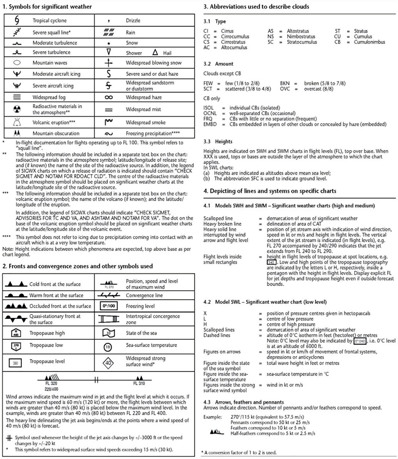
FLIGHT DOCUMENTATION — LEGEND FOR THE CHARTS
When the flight documentation related to forecasts of upper wind and upper-air temperature and SIGWX phenomena is presented in the form of charts, it should be in accordance with the below sheet of notations used in flight documentation.
GM1 MET.TR.215(e)(1) & (2) Forecasts and other information
ED Decision 2022/004/R
MODEL CHARTS
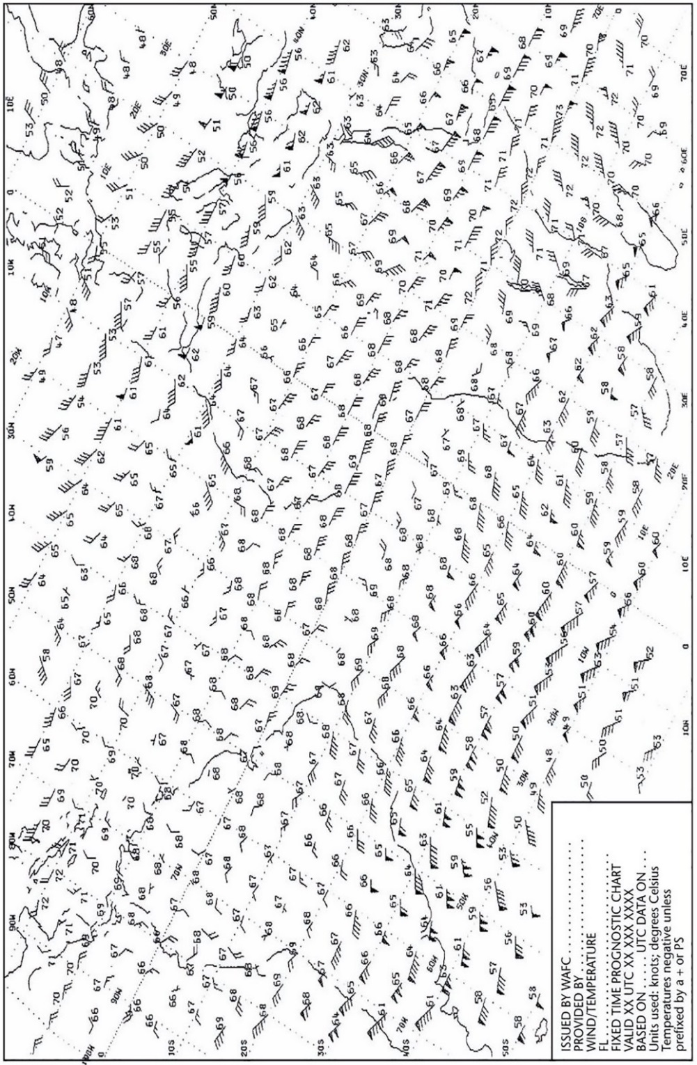
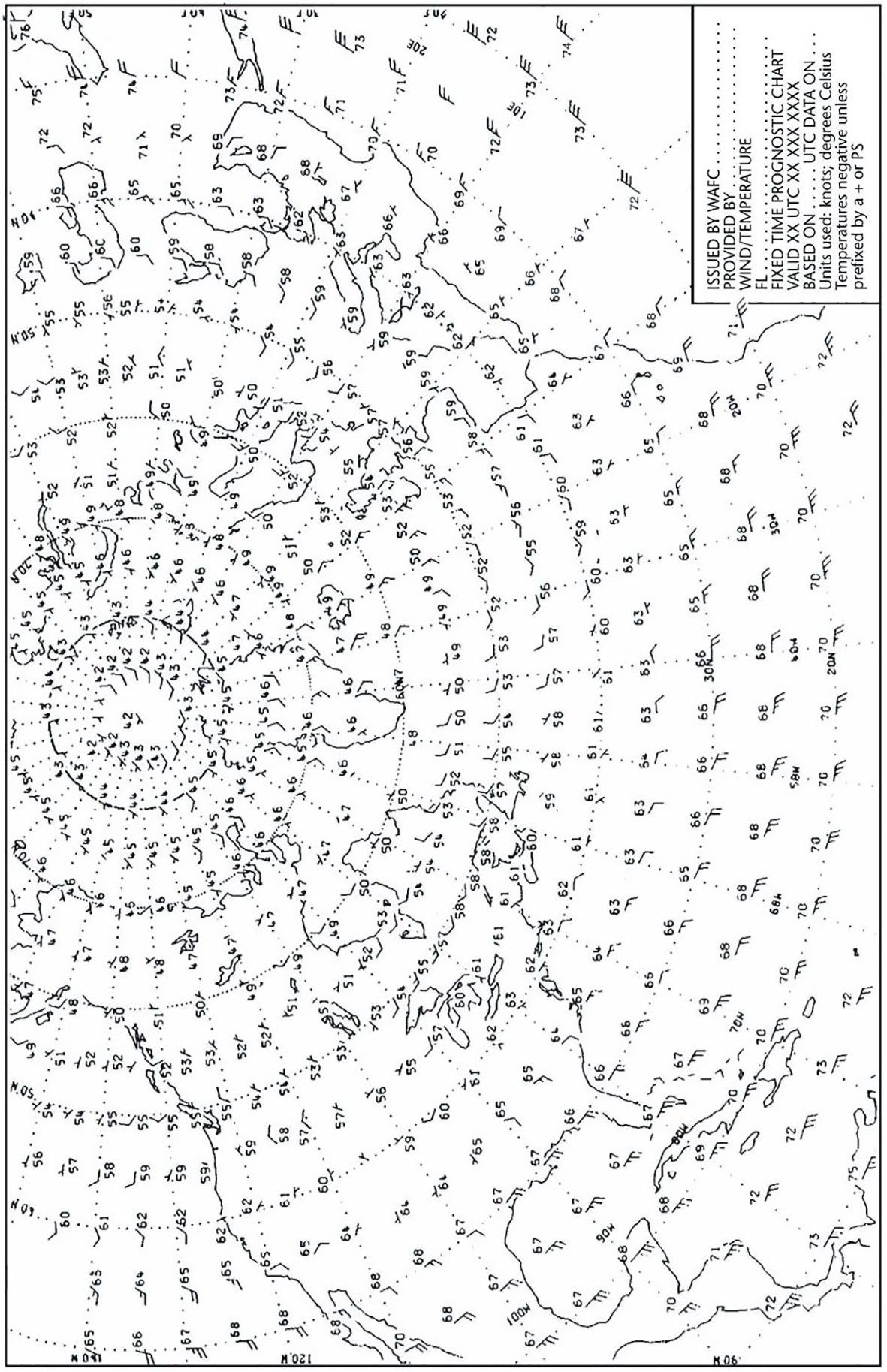
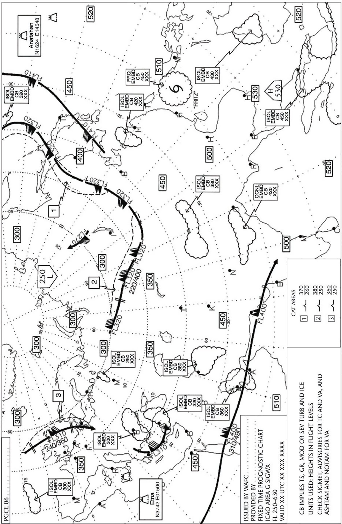
This guidance provides examples of model charts.
(a)UPPER WIND AND TEMPERATURE CHART FOR STANDARD ISOBARIC SURFACE
MODEL IS
Example 1. Arrows, feathers and pennants (Mercator projection)
(b)UPPER WIND AND TEMPERATURE CHART FOR STANDARD ISOBARIC SURFACE
MODEL IS
Example 2. Arrows, feathers and pennants (Polar stereographic projection)
(c)SIGNIFICANT WEATHER CHART (HIGH LEVEL)
MODEL SWH
Example. Polar stereographic projection (showing the jet stream vertical extent)
(d)SIGNIFICANT WEATHER CHART (MEDIUM LEVEL)
MODEL SWM
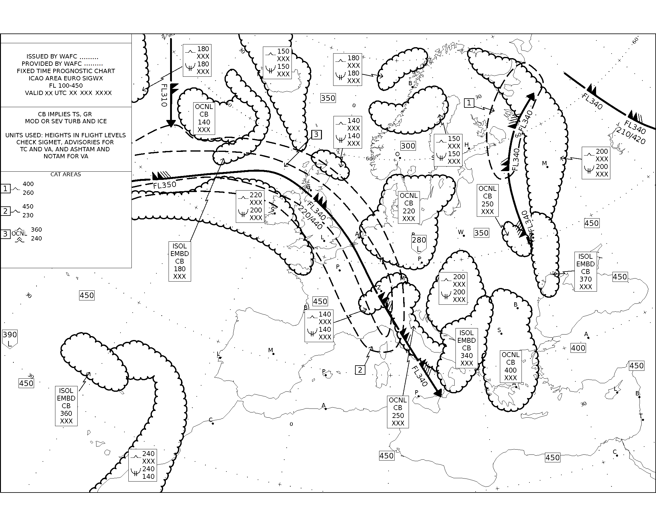
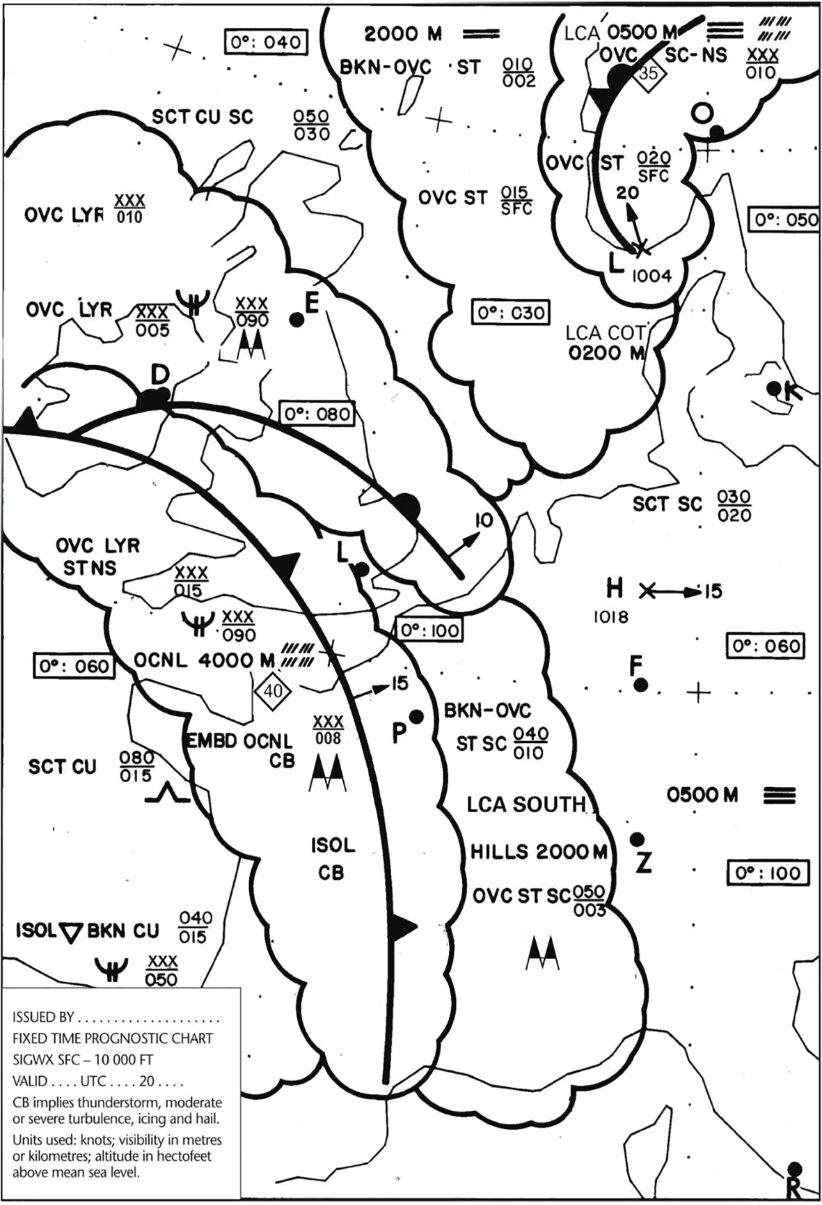
(e)SIGNIFICANT WEATHER CHART (LOW LEVEL)
MODEL SWL
Example 1
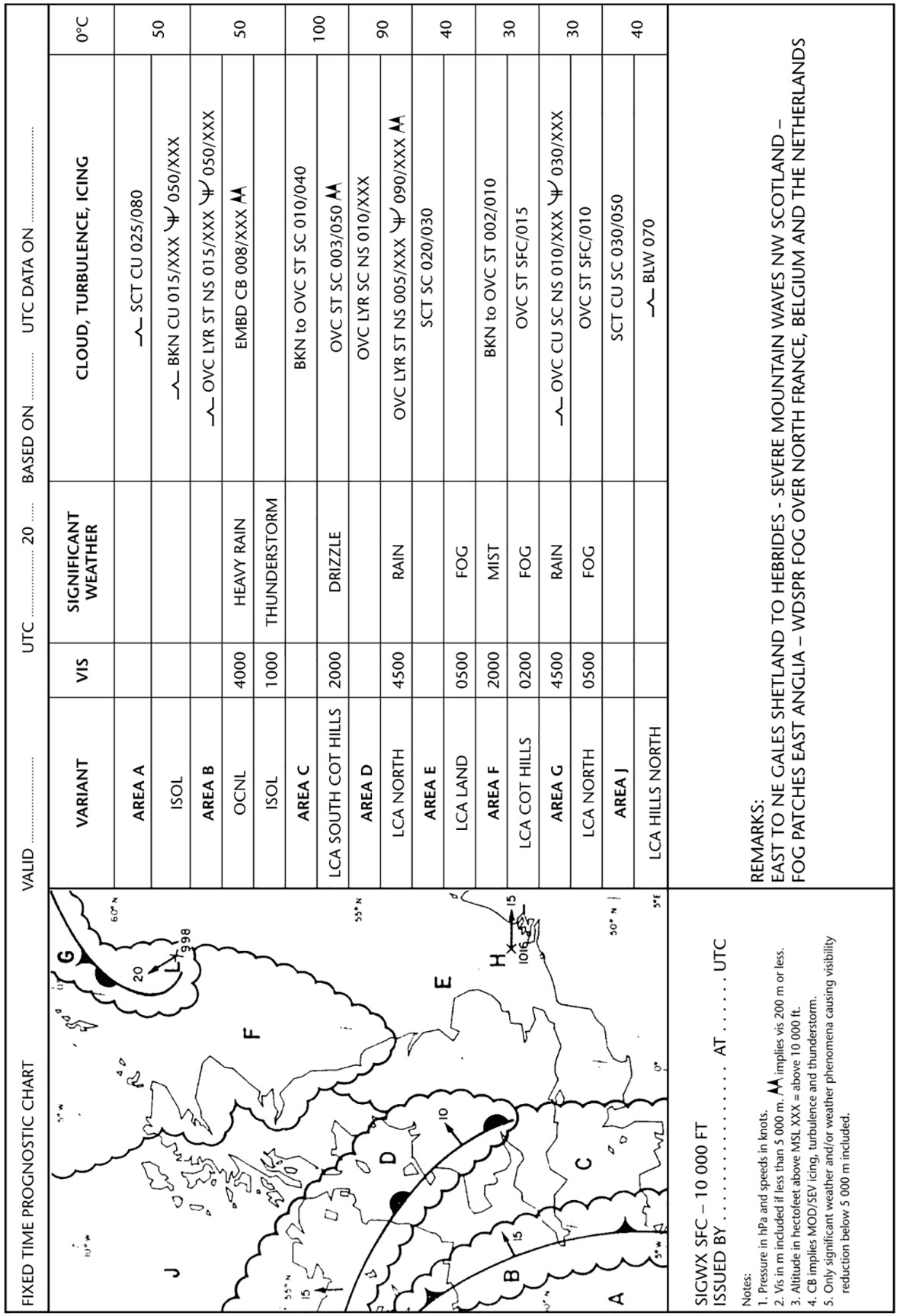
(f)SIGNIFICANT WEATHER CHART (LOW LEVEL)
MODEL SWL
Example 2
AMC2 MET.TR.215(e)(1) & (2) Forecasts and other information
ED Decision 2017/001/R
FORMAT OF FLIGHT DOCUMENTATION
The location indicators and the abbreviations used should be explained in the flight documentation.
AMC1 MET.TR.215(f) Forecasts and other information
ED Decision 2020/008/R
CHARTS
Charts included in flight documentation should have a high standard of clarity and legibility and should have the following physical characteristics:
(a)For convenience, the largest size of charts should be about 42 × 30 cm (standard A3 size) and the smallest size should be about 21 × 30 cm (standard A4 size). The choice between these sizes should depend on the route lengths and the amount of detail that needs to be given in the charts as agreed between the aerodrome meteorological office and the users concerned;
(b)Major geographical features, such as coastlines, major rivers and lakes, should be depicted in a way that makes them easily recognisable;
(c)For charts prepared by computer, meteorological data should take preference over basic chart information, the former cancelling the latter wherever they overlap;
(d)Major aerodromes should be shown as a dot and identified by the first letter of the name of the city the aerodrome serves as given in Table AOP of the EUR air navigation plan;
(e)A geographical grid should be shown with meridians and parallels represented by dotted lines at each 10°-latitude and longitude; dots should be spaced one degree apart;
(f)Latitude and longitude values should be indicated at various points throughout the charts; and
(g)Labels on the charts for flight documentation should be clear and simple and should present the name of the world area forecast centre or, for non-WAFS products, the originating centre, the type of chart, date and valid time and, if necessary, the types of units used in an unambiguous way.
AMC2 MET.TR.215(f) Forecasts and other information
ED Decision 2022/004/R
CHARTS
(a)The minimum number of charts for flights between flight level 250 and flight level 630 should include a high-level SIGWX chart (flight level 250 to flight level 630) or a medium-level SIGWX chart (flight level 100 to flight level 450), if appropriate, and a forecast flight level 340 wind and temperature chart.
(b)The actual charts provided for pre-flight and in-flight planning and for flight documentation should be agreed between the meteorological providers and the users concerned.
GM1 MET.TR.215(f) Forecasts and other information
ED Decision 2017/001/R
CHARTS — SHORT-HAUL FLIGHTS
For short-haul flights, charts should be prepared covering limited areas at a scale of 1:15 × 10⁶ as required.
GM2 MET.TR.215(f) Forecasts and other information
ED Decision 2022/004/R
MAP PROJECTIONS — CORRECT CONVERSION BETWEEN DIFFERENT MAP PROJECTIONS
When plotting shapes, particularly polygons, on maps, appropriate corrections are necessary if they are plotted on projections different to those used in the production of the original forecast area.
GM1 MET.TR.215(g) Forecasts and other information
ED Decision 2020/008/R
FORECASTS IN CHART FORM
(a)Charts related to concatenated route-specific upper wind and upper-air temperature forecasts should be provided as agreed between the meteorological service provider and the operator concerned.
(b)Guidance on the design, formulation and use of concatenated charts is given in ICAO DOC 8896 'Manual of Aeronautical Meteorological Practice' as last amended.
AMC1 MET.TR.215(i) Forecasts and other information
ED Decision 2017/001/R
CLIMATOLOGICAL INFORMATION — PERIOD OF OBSERVATION
Aeronautical climatological information should be based on observations made over a period of at least five years. The period should be indicated in the information supplied.
AMC2 MET.TR.215(i) Forecasts and other information
ED Decision 2017/001/R
CLIMATOLOGICAL DATA RELATED TO SITES FOR NEW AERODROMES
Climatological data related to sites for new aerodromes and to additional runways at existing aerodromes should be collected starting as early as possible before the commissioning of those aerodromes or runways.
AMC3 MET.TR.215(i) Forecasts and other information
ED Decision 2017/001/R
CLIMATOLOGICAL SUMMARIES
Aerodrome climatological summaries should follow the procedures prescribed by the World Meteorological Organization and should be made available in a form to meet a specific user request.
AMC4 MET.TR.215(i) Forecasts and other information
ED Decision 2017/001/R
CLIMATOLOGICAL TABLE
An aerodrome climatological table should indicate:
(a)mean values and variations therefrom, including maximum and minimum values, of meteorological elements; and/or
(b)the frequency of occurrence of present weather phenomena affecting flight operations at the aerodrome; and/or
(c)the frequency of occurrence of specified values of one, or of a combination of two or more, elements.
AMC5 MET.TR.215(i) Forecasts and other information
ED Decision 2017/001/R
CLIMATOLOGICAL TABLE
Aerodrome climatological tables should include information required for the preparation of aerodrome climatological summaries.
AMC6 MET.TR.215(i) Forecasts and other information
ED Decision 2017/001/R
CLIMATOLOGICAL SUMMARIES
Aerodrome climatological summaries should cover:
(a)frequencies of the occurrence of runway visual range/visibility and/or height of base of the lowest cloud layer of BKN or OVC extent below specified values at specified times;
(b)frequencies of visibility below specified values at specified times;
(c)frequencies of the height of base of the lowest cloud layer of BKN or OVC extent below specified values at specified times;
(d)frequencies of occurrence of concurrent wind direction and speed within specified ranges;
(e)frequencies of surface temperature in specified ranges of 5°C at specified times; and
(f)mean values and variations therefrom, including maximum and minimum values of meteorological elements required for operational planning purposes, including take-off performance calculations.
GM1 MET.TR.215(i) Forecasts and other information
ED Decision 2017/001/R
CLIMATOLOGICAL INFORMATION
In cases where it is impracticable to meet the requirements for aeronautical climatological information on a national basis, the collection, processing and storage of observational data may be effected through computer facilities available for international use, and the responsibility for the preparation of the required aeronautical climatological information may be delegated by agreement between the competent authorities concerned.
GM2 MET.TR.215(i) Forecasts and other information
ED Decision 2020/008/R
CLIMATOLOGICAL SUMMARIES — MODELS
Models of climatological summaries related to (a) to (e) of AMC6 MET.TR.215(i) are given in the WMO Publication No 49, Technical Regulations, Volume II, Part III – ‘AERONAUTICAL CLIMATOLOGY’.
GM3 MET.TR.215(i) Forecasts and other information
ED Decision 2022/004/R
CLIMATOLOGICAL DATA FOR AERODROME PLANNING PURPOSES
Climatological data required for aerodrome planning purposes is set out in GM1 ADR-DSN.B.025 ‘Data to be used’.
MET.TR.220 Aerodrome forecasts
Regulation (EU) 2021/1338
(a)Aerodrome forecasts and amendments thereto shall be issued as a TAF and shall include, in the order indicated, the:
(1)identification of the type of forecast;
(2)location indicator;
(3)time of issue of forecast;
(4)identification of a missing forecast, when applicable;
(5)date and period of validity of forecast;
(6)identification of a cancelled forecast, when applicable;
(7)surface wind;
(8)visibility;
(9)weather;
(10)cloud;
(11)expected significant changes to one or more of these elements during the period of validity.
(b)TAF shall be issued in accordance with the template shown in Appendix 3.
(c)The period of validity of a routine TAF shall be either 9 or 24 or 30 hours, unless otherwise prescribed by the competent authority taking into account the traffic requirements for aerodromes which operate for less than 9 hours.
(d)TAF shall be filed for transmission not earlier than 1 hour before the commencement of their period of validity.
(e)The meteorological elements included in TAF shall be:
(1)Surface wind
(i)In forecasting surface wind, the expected prevailing direction shall be given.
(ii)When it is not possible to forecast a prevailing surface wind direction due to its expected variability, the forecasted wind direction shall be indicated as variable using ‘VRB’.
(iii)When the wind is forecasted to be less than 1 kt, the forecasted wind speed shall be indicated as calm.
(iv)When the forecast maximum speed exceeds the forecasted mean wind speed by 10 kt or more, the forecasted maximum wind speed shall be indicated.
(v)When a wind speed of 100 kt or more is forecasted, it shall be indicated to be more than 99 kt.
(2)Visibility
(i)When the visibility is forecasted to be less than 800 m, it shall be expressed in steps of 50 m; when it is forecasted to be 800 m or more, but less than 5 km, in steps of 100 m; when it is forecasted to be 5 km or more, but less than 10 km, in kilometre steps; and when it is forecasted to be 10 km or more, it shall be expressed as 10 km, except when conditions of CAVOK are forecasted to apply. The prevailing visibility shall be forecasted.
(ii)When visibility is forecasted to vary in different directions and the prevailing visibility cannot be forecasted, the lowest forecasted visibility shall be given.
(3)Weather phenomena
(i)One or more, up to a maximum of three, of the following weather phenomena or combinations thereof, together with their characteristics and, where appropriate, intensity, shall be forecasted if they are expected to occur at the aerodrome:
(A)freezing precipitation;
(B)freezing fog;
(C)moderate or heavy precipitation (including showers thereof);
(D)low drifting dust, sand or snow;
(E)blowing dust, sand or snow;
(F)dust storm;
(G)sandstorm;
(H)thunderstorm (with or without precipitation);
(I)squall;
(J)funnel cloud (tornado or waterspout);
(K)other weather phenomena, as agreed by the aerodrome meteorological office with the ATS units and operators concerned.
(ii)The expected end of occurrence of those phenomena shall be indicated by the abbreviation ‘NSW’.
(4)Cloud
(i)The cloud amount shall be forecast using the abbreviations ‘FEW’, ‘SCT’, ‘BKN’ or ‘OVC’, as necessary. When it is expected that the sky will remain or become obscured and clouds cannot be forecasted and information on vertical visibility is available at the aerodrome, the vertical visibility shall be forecasted in the form ‘VV’ followed by the forecasted value of the vertical visibility.
(ii)When several layers or masses of cloud are forecasted, their amount and height of base shall be included in the following order:
(A)the lowest layer or mass regardless of amount, to be forecasted as FEW, SCT, BKN or OVC as appropriate;
(B)the next layer or mass covering more than 2/8, to be forecast as SCT, BKN or OVC as appropriate;
(C)the next higher layer or mass covering more than 4/8, to be forecast as BKN or OVC as appropriate;
(D)cumulonimbus clouds and/or towering cumulus clouds, whenever forecasted and not already included under points (A) to (C).
(iii)Cloud information shall be limited to cloud of operational significance; when no cloud of operational significance is forecasted and ‘CAVOK’ is not appropriate, the abbreviation ‘NSC’ shall be used.
(f)Use of change groups
(1)The criteria used for the inclusion of change groups in TAF or for the amendment of TAF shall be based on any of the following weather phenomena, or combinations thereof, being forecasted to begin or end or change in intensity:
(i)freezing fog;
(ii)freezing precipitation;
(iii)moderate or heavy precipitation (including showers thereof);
(iv)thunderstorm;
(v)dust storm;
(vi)sandstorm.
(2)When a change in any of the elements given in point (a) is required to be indicated, the change indicators ‘BECMG’ or ‘TEMPO’ shall be used followed by the time period during which the change is expected to occur. The time period shall be indicated as the beginning and end of the period in whole hours UTC. Only those elements for which a significant change is expected shall be included following a change indicator. However, in the case of significant changes in respect of cloud, all cloud groups, including layers or masses not expected to change, shall be indicated.
(3)The change indicator ‘BECMG’ and the associated time group shall be used to describe changes where the meteorological conditions are expected to reach or pass through specified threshold values at a regular or irregular rate and at an unspecified time during the time period. The time period shall not exceed 4 hours.
(4)The change indicator ‘TEMPO’ and the associated time group shall be used to describe expected frequent or infrequent temporary fluctuations in the meteorological conditions which reach or pass specified threshold values and last for a period of less than 1 hour in each instance and, in the aggregate, cover less than one half of the forecast period during which the fluctuations are expected to occur. If the temporary fluctuation is expected to last 1 hour or longer, the change group ‘BECMG’ shall be used in accordance with point (3), or the validity period should be subdivided in accordance with point (5).
(5)Where one set of prevailing weather conditions is expected to change significantly and more or less completely to a different set of conditions, the period of validity shall be subdivided into self-contained periods using the abbreviation ‘FM’ followed immediately by a six-figure time group in days, hours and minutes UTC indicating the time the change is expected to occur. The subdivided period following the abbreviation ‘FM’ shall be self-contained and all forecasted conditions given before the abbreviation shall be superseded by those following the abbreviation.
(g)The probability of occurrence of an alternative value of a forecast element or elements shall be included when:
(1)a 30 % or 40 % probability of alternative meteorological conditions exists during a specific forecast time period; or
(2) a 30 % or 40 % probability of temporary fluctuations in meteorological conditions exists during a specific forecast time period.
This shall be indicated in the TAF by using the abbreviation ‘PROB’ followed by the probability in tens of per cent and, in the case referred to in point (1), the time period during which the values are expected to apply, or in the case referred to in point (2), by using the abbreviation ‘PROB’ followed by the probability in tens of per cent, the change indicator ‘TEMPO’ and associated time group.
GM1 MET.TR.220 Aerodrome forecasts
ED Decision 2020/008/R
TAF — EXAMPLES
TAF for YUDO (Donlon/International)*: TAF YUDO 152300Z 1600/1706 13010KT 9000 BKN025 BECMG 1606/1608 BKN014CB BKN020 TEMPO 1608/1612 17015G25KT 1000 TSRA BKN009CB BKN020 FM161230 15008KT 9999 BKN020 Meaning of the forecast: TAF for Donlon/International* issued on the 15th of the month at 23.00 UTC valid from 00.00 UTC to * Fictitious location |
GM2 MET.TR.220 Aerodrome forecasts
ED Decision 2022/004/R
TAF — EXAMPLE OF CANCELLATION
Cancellation of TAF for YUDO (Donlon/International)*: TAF AMD YUDO 161845Z 1618/1703 CNL Meaning of the forecast: Amended TAF for Donlon/International* issued on the 16th of the month at 18.45 UTC cancelling the previously issued TAF valid from 18.00 UTC on the 16th of the month to 03.00 UTC on the 17th of the month. * Fictitious location |
GM3 MET.TR.220 Aerodrome forecasts
ED Decision 2022/004/R
TAF — ACCURACY
The accuracy of TAF should be monitored using appropriate verification methodologies as agreed with the competent authority. The verification should identify the accuracy of the forecast against the required change criteria for the forecast elements: wind direction, wind speed, visibility, precipitation, cloud amount, and cloud height. Where provided, maximum and minimum temperature forecasts in TAF should be verified.
GM1 MET.TR.220(a)(8) Aerodrome forecasts
ED Decision 2017/001/R
VISIBILITY
The visibility included in TAF refers to the forecast prevailing visibility.
AMC1 MET.TR.220(b) Aerodrome forecasts
ED Decision 2022/004/R
TAF — CODE FORM
TAF, and amendments thereto, should be encoded using:
(a)the IWXXM GML form as specified in point (a) of AMC1 MET.TR.115(a); and
(b)the alphanumeric code form for TAF as specified in point (b) of AMC1 MET.TR.115(a).
AMC1 MET.TR.220(c) Aerodrome forecasts
ED Decision 2022/004/R
PERIOD OF VALIDITY
(a)The periods of validity for an up to 9-hour TAF should commence at 00, 03, 06, 09, 12, 15, 18 and 21 UTC and for a 24- and a 30-hour TAF at 00, 06, 12 and 18 UTC or 03, 09, 15, and 21 UTC.
(b)The 24- and 30-hour TAF periods of validity should be determined based on the types of operations, as agreed between the aerodrome meteorological office and the operators concerned.
(c)A routine TAF valid for up to 9 hours should be issued every 3 hours, and those valid for 24 or 30 hours should be issued every 6 hours.
(d) If so agreed between the competent authority and the meteorological services provider, TAF valid for 24 or 30 hours may be issued every 3 hours, and the validity should commence at 00, 03, 06, 09, 12, 15, 18 and 21 UTC.
(e)At aerodromes with limited hours of operation, the beginning of the period of validity of a TAF should commence at least 1 hour prior to the aerodrome resuming operations, or more as agreed between the aerodrome meteorological office and the operators concerned, to meet planning requirements for flights that arrive at the aerodromes as soon as it is opened for use.
GM1 MET.TR.220(e)(2)(i) Aerodrome forecasts
ED Decision 2022/004/R
TAF — PHENOMENA REDUCING VISIBILITY
When the visibility is forecast to be 5 000 m or less, the forecast weather phenomenon reducing visibility may be included in TAF, e.g. phenomena, and combinations thereof, such as FG, BR, HZ,
-RA, -SN, etc.
AMC1 MET.TR.220(f) Aerodrome forecasts
ED Decision 2017/001/R
TAF — USE OF CHANGE GROUPS
The criteria used for the inclusion of change groups in TAF or amendments to TAF should be based on the following:
(a)when the mean surface wind direction is forecasted to change by 60° or more, the mean speed before and/or after the change being 10 kt (5 m/s) or more;
(b)when the mean surface wind speed is forecasted to change by 10 kt (5 m/s) or more;
(c)when the variation from the mean surface wind speed (gusts) is forecasted to change by 10 kt (5 m/s) or more, the mean speed before and/or after the change being 15 kt (7.5 m/s) or more;
(d)when the surface wind is forecasted to change through values of operational significance;
(e)when the visibility is forecasted to improve and change to or pass through one or more of the following values, or when the visibility is forecasted to deteriorate and pass through one or more of the following values:
(1)150, 350, 600, 800, 1 500 or 3 000 m; and
(2)5 000 m in cases where significant numbers of flights are operated in accordance with the visual flight rules;
(f)when any of the following weather phenomena, or combinations thereof, are forecasted to begin or end:
(1)low drifting dust, sand or snow;
(2)blowing dust, sand or snow;
(3)squall; and
(4)funnel cloud (tornado or waterspout);
(g)when the height of base of the lowest layer or mass of cloud of BKN or OVC extent is forecasted to lift and change to or pass through one or more of the following values, or when the height of the lowest layer or mass of cloud of BKN or OVC extent is forecasted to lower and pass through one or more of the following values:
(1)100, 200, 500 or 1 000 ft (30, 60, 150 or 300 m); or
(2)1 500 ft (450 m) in cases where significant numbers of flights are operated in accordance with the visual flight rules;
(h)when the amount of a layer or mass of cloud below 1 500 ft (450 m) is forecasted to change:
(1)from NSC, FEW or SCT to BKN or OVC; or
(2)from BKN or OVC to NSC, FEW or SCT;
(i)when the vertical visibility is forecasted to improve and change to or pass through one or more of the following values, or when the vertical visibility is forecasted to deteriorate and pass through one or more of the following values: 100, 200, 500 or 1 000 ft (30, 60, 150 or 300 m); and
(j)any other criteria based on local aerodrome operating minima, as agreed between the aerodrome meteorological office and the operators.
GM1 MET.TR.220(f)(1) Aerodrome forecasts
ED Decision 2022/004/R
TAF — USE OF CHANGE AND TIME INDICATORS
Guidance on the use of change and time indicators in TAF is given below:
Change or time indicator | Time period | Meaning | ||
FM | ndndnhnhnmnm | Used to indicate a significant change in most weather elements occurring at ndnd day, nhnh hours and nmnm minutes (UTC); All the elements given before ‘FM’ are to be included following ‘FM’ (i.e. they are all superseded by those following the abbreviation). | ||
BECMG | nd1nd1nh1nh1/nd2nd2nh2nh2 | The change is forecast to commence at nd1nd1 day and nh1nh1 hours (UTC) and be completed by nd2nd2 day and nh2nh2 hours (UTC); Only those elements for which a change is forecast are to be given following ‘BECMG’; The time period nd1nd1nh1nh1/nd2nd2nh2nh2 should normally be less than 2 hours and in any case should not exceed 4 hours. | ||
TEMPO | nd1nd1nh1nh1/nd2nd2nh2nh2 | Temporary fluctuations are forecast to commence at nd1nd1 day and nh1nh1 hours (UTC) and cease by nd2nd2 day and nh2nh2 hours (UTC); Only those elements for which fluctuations are forecast are to be given following ‘TEMPO’; temporary fluctuations should last less than 1 hour in each instance, and in the aggregate, cover less than half of the period nd1nd1nh1nh1/nd2nd2nh2nh2. | ||
PROBnn | — | nd1nd1nh1nh1/nd2nd2nh2nh2 | Probability of occurrence (in %) of an alternative value of a forecast element or elements; nn = 30 or nn = 40 only; To be placed after the element(s) concerned. | — |
TEMPO | nd1nd1nh1nh1/nd2nd2nh2nh2 | Probability of occurrence of temporary fluctuations. | ||
AMC1 MET.TR.220(g) Aerodrome forecasts
ED Decision 2017/001/R
USE OF PROBABILITY INDICATORS
(a)The number of change and probability groups should be kept to a minimum.
(b)The probability of occurrence of an alternative value of a forecast element or elements should be placed after the element or elements forecast and be followed by the alternative value of the element or elements.
GM1 MET.TR.220(g) Aerodrome forecasts
ED Decision 2017/001/R
USE OF PROBABILITY INDICATORS
(a)A probability of an alternative value or change of less than 30 % should not be considered sufficiently significant to be indicated.
(b)A probability of an alternative value or change of 50 % or more should not be considered a probability but, instead, should be indicated, as necessary, by use of the change indicators ‘BECMG’ or ‘TEMPO’ or by subdivision of the validity period using the abbreviation ‘FM’. The probability group should neither be used to qualify the change indicator ‘BECMG’ nor the time indicator ‘FM’.
MET.TR.225 Forecasts for landing
Regulation (EU) 2021/1338
(a)TREND forecasts shall be issued in accordance with Appendix 1.
(b)The units and scales used in the TREND forecast shall be the same as those used in the report to which it is appended.
(c)The TREND forecast shall indicate significant changes in respect of one or more of the elements: surface wind, visibility, weather phenomena and clouds. Only those elements for which a significant change is expected shall be included. However, in the case of significant changes in respect of cloud, all cloud groups, including layers or masses not expected to change, shall be indicated. In the case of a significant change in visibility, the phenomenon causing the reduction of visibility shall also be indicated. When no change is expected to occur, this shall be indicated by the term ‘NOSIG’.
(1)Surface wind
The TREND forecast shall indicate changes in the surface wind which involve:
(i)a change in the mean wind direction of 60° or more, the mean speed before and/or after the change being 10 kt or more;
(ii)a change in mean wind speed of 10 kt or more
(iii)changes in the wind through values of operational significance.
(2)Visibility
(i)When the visibility is expected to improve and change to or pass through one or more of the following values, or when the visibility is expected to deteriorate and pass through one or more of the following values: 150, 350, 600, 800, 1 500 or 3 000 m, the TREND forecast shall indicate the change.
(ii)When significant numbers of flights are conducted in accordance with the visual flight rules, the forecast shall additionally indicate changes to or passing through 5 000 m.
(iii)In TREND forecasts appended to METAR and SPECI, visibility shall refer to the forecast prevailing visibility.
(3)Weather phenomena
(i)The TREND forecast shall indicate the expected onset, cessation or change in intensity of any of the following weather phenomena or combinations thereof:
(A)freezing precipitation;
(B)moderate or heavy precipitation, including showers thereof;
(C)thunderstorm, with precipitation;
(D)dust storm;
(E)sandstorm;
(F)other weather phenomena as agreed by the aerodrome meteorological office with the ATS units and operators concerned.
(ii)The TREND forecast shall indicate the expected onset or cessation of any of the following weather phenomena or combinations thereof:
(A)freezing fog;
(B)low drifting dust, sand or snow;
(C)blowing dust, sand or snow;
(D)thunderstorm (without precipitation);
(E)squall;
(F)funnel cloud (tornado or waterspout).
(iii)The total number of phenomena reported in points (i) and (ii) shall not exceed three.
(iv)The expected end of occurrence of the weather phenomena shall be indicated by the abbreviation ‘NSW’.
(4)Clouds
(i)When the height of base of a cloud layer of BKN or OVC extent is expected to lift and change to or pass through one or more of the following values, or when the height of base of a cloud layer of BKN or OVC extent is expected to lower and pass through one or more of the following values: 100, 200, 500, 1 000 and 1 500 ft (30, 60, 150, 300 and 450 m), the TREND forecast shall indicate the change.
(ii)When the height of base of a cloud layer is below or is expected to fall below or rise above 1 500 ft (450 m), the TREND forecast shall also indicate changes in cloud amount from FEW, or SCT increasing to BKN or OVC, or changes from BKN or OVC decreasing to FEW or SCT.
(iii)When no clouds of operational significance are forecast and ‘CAVOK’ is not appropriate, the abbreviation ‘NSC’ shall be used.
(5)Vertical visibility
When the sky is expected to remain or become obscured and vertical visibility observations are available at the aerodrome, and the vertical visibility is forecast to improve and change to or pass through one or more of the following values, or when the vertical visibility is forecast to deteriorate and pass through one or more of the following values: 100, 200, 500 or 1 000 ft (30, 60, 150 or 300 m), the TREND forecast shall indicate the change.
(6)Additional criteria
The aerodrome meteorological office and the users may agree on additional criteria to be used, based on local aerodrome operating minima.
(7)Use of change groups
(i)When a change is expected to occur, the TREND forecast shall begin with one of the change indicators ‘BECMG’ or ‘TEMPO’.
(ii)The change indicator ‘BECMG’ shall be used to describe forecast changes where the meteorological conditions are expected to reach or pass through specified values at a regular or irregular rate. The period during which, or the time at which, the change is forecast to occur shall be indicated using the abbreviations ‘FM’, ‘TL’ or ‘AT’, as appropriate, each followed by a time group in hours and minutes.
(iii)The change indicator ‘TEMPO’ shall be used to describe forecast temporary fluctuations in the meteorological conditions which reach or pass specified values and last for a period of less than 1 hour in each instance and, in the aggregate, cover less than one half of the period during which the fluctuations are forecast to occur. The period during which the temporary fluctuations are forecast to occur shall be indicated using the abbreviations ‘FM’ and/or ‘TL’, as appropriate, each followed by a time group in hours and minutes.
(8)Use of the probability indicator
The indicator ‘PROB’ shall not be used in TREND forecasts.
AMC1 MET.TR.225(c)(1)(iii) Forecasts for landing
ED Decision 2017/001/R
THRESHOLD VALUES
The threshold values should be established by the aerodrome meteorological office in consultation with the appropriate ATS units and operators concerned, taking into account changes in the wind which would:
(a)require a change in runway(s) in use; and
(b)indicate that the runway tailwind and crosswind components will change through values representing the main operating limits for typical aircraft operating at the aerodrome.
GM1 MET.TR.225(c)(2)(iii) Forecasts for landing
ED Decision 2020/008/R
VISIBILITY
In TREND forecasts appended to local routine report and local special report, visibility refers to the forecast visibility along the runway(s).
AMC1 MET.TR.225(c)(7)(ii) Forecasts for landing
ED Decision 2017/001/R
USE OF CHANGE GROUPS — BECMG
(a)When the change is forecast to begin and end wholly within the trend forecast period, the beginning and end of the change should be indicated by using the abbreviations ‘FM’ and ‘TL’, respectively, with their associated time groups.
(b)When the change is forecast to commence at the beginning of the trend forecast period but be completed before the end of that period, the abbreviation ‘FM’ and its associated time group should be omitted and only ‘TL’ and its associated time group should be used.
(c)When the change is forecast to begin during the trend forecast period and be completed at the end of that period, the abbreviation ‘TL’ and its associated time group should be omitted and only ‘FM’ and its associated time group should be used.
(d)When the change is forecast to occur at a specified time during the trend forecast period, the abbreviation ‘AT’ followed by its associated time group should be used.
(e)When the change is forecast to commence at the beginning of the trend forecast period and be completed by the end of that period, or when the change is forecast to occur within the trend forecast period but the time is uncertain, the abbreviations ‘FM’, ‘TL’ or ‘AT’ and their associated time groups should be omitted and the change indicator ‘BECMG’ should be used alone.
GM1 MET.TR.225(c)(7)(ii) Forecasts for landing
ED Decision 2022/004/R
TREND FORECASTS — USE OF CHANGE INDICATORS
Guidance on the use of change indicators in trend forecasts is given in the table below.
Change indicator | Time indicator and period | Meaning | |
NOSIG | — | no significant changes are forecast | |
BECMG | FMn1n1n1n1 TLn2n2n2n2 | the change is forecast to | commence at n1n1n1n1 UTC and be completed by n2n2n2n2 UTC |
TLnnnn | commence at the beginning of the trend forecast period and be completed by nnnn UTC | ||
FMnnnn | commence at nnnn UTC and be completed by the end of the trend forecast period | ||
ATnnnn | occur at nnnn UTC (specified time) | ||
— | commence at the beginning of the trend forecast period and be completed by the end of the trend forecast period; or the time is uncertain | ||
TEMPO | FMn1n1n1n1 TLn2n2n2n2 | temporary fluctuations are forecast to | commence at n1n1n1n1 UTC and cease by n2n2n2n2 UTC |
TLnnnn | commence at the beginning of the trend forecast period and cease by nnnn UTC | ||
FMnnnn | commence at nnnn UTC and cease by the end of | ||
— | commence at the beginning of the trend forecast period and cease by the end of the trend forecast period | ||
AMC1 MET.TR.225(c)(7)(iii) Forecasts for landing
ED Decision 2022/004/R
USE OF CHANGE GROUPS — TEMPO
(a)When the period of the temporary fluctuations in the meteorological conditions is forecast to begin and end wholly within the TREND forecast period, the beginning and end of the period of the temporary fluctuations should be indicated by using the abbreviations ‘FM’ and ‘TL’ respectively, with their associated time groups.
(b)When the period of the temporary fluctuations is forecast to commence at the beginning of the TREND forecast period but cease before the end of that period, the abbreviation ‘FM’ and its associated time group should be omitted and only ‘TL’ and its associated time group should be used.
(c)When the period of the temporary fluctuations is forecast to begin during the TREND forecast period and cease by the end of that period, the abbreviation ‘TL’ and its associated time group should be omitted and only ‘FM’ and its associated time group should be used.
(d)When the period of the temporary fluctuations is forecast to commence at the beginning of the TREND forecast period and cease by the end of that period, both abbreviations ‘FM’ and ‘TL’ and their associated time groups should be omitted and the change indicator ‘TEMPO’ should be used alone.
MET.TR.230 Forecasts for take-off
Regulation (EU) 2017/373
(a)A forecast for take-off shall refer to a specified period of time and shall contain information on expected conditions over the runway complex in regard to surface wind direction and speed and any variations thereof, temperature, pressure, and any other elements as agreed between the aerodrome meteorological office and the operators.
(b)The order of the elements and the terminology, units and scales used in forecasts for take-off shall be the same as those used in reports for the same aerodrome.
AMC1 MET.TR.230(a) Forecasts for take-off
ED Decision 2017/001/R
AMENDMENTS TO FORECASTS
(a)The criteria for the issuance of amendments to forecasts for take-off for surface wind direction and speed, temperature and pressure, and any other elements agreed locally should be agreed between the aerodrome meteorological office and the operators concerned.
(b)The criteria should be consistent with the corresponding criteria for special reports established for the aerodrome.
MET.TR.235 Aerodrome warnings and wind shear warnings and alerts
Regulation (EU) 2021/1338
(a)Wind shear warnings shall be issued in accordance with the template in Appendix 4.
(b)The sequence number referred to in the template in Appendix 4 shall correspond to the number of wind shear warnings issued for the aerodrome since 00.01 UTC on the day concerned.
(c)Wind shear alerts shall give concise, up-to-date information related to the observed existence of wind shear involving a headwind/tailwind change of 15 kt or more which could adversely affect aircraft on the final approach path or initial take-off path and aircraft on the runway during the landing roll or take-off run.
(d)Wind shear alert shall, if practicable, relate to specific sections of the runway and distances along the approach path or take-off path as agreed between the aerodrome meteorological office, the appropriate ATS units and the operators concerned.