

Filters
ANNEX VI — Part-AIS
SPECIFIC REQUIREMENTS FOR THE PROVIDERS OF AERONAUTICAL INFORMATION SERVICES
SUBPART A – ADDITIONAL ORGANISATION REQUIREMENTS FOR PROVIDERS OF AERONAUTICAL INFORMATION SERVICES (AIS.OR)
SECTION 1 — GENERAL REQUIREMENTS
AIS.OR.100 Aeronautical information management
Commission Implementing Regulation (EU) 2020/469
An aeronautical information services (AIS) provider shall establish information management resources and processes that are adequate to ensure the timely collection, processing, storing, integration, exchange and delivery of quality- assured aeronautical data and aeronautical information within the ATM system.
GM1 AIS.OR.100 Aeronautical information management
ED Decision 2020/008/R
AERONAUTICAL INFORMATION
(a)The object of aeronautical information services is to ensure the flow of aeronautical data and aeronautical information necessary for global air traffic management (ATM) system safety, regularity, economy and efficiency in an environmentally sustainable manner.
(b)The role and importance of aeronautical data and aeronautical information changed significantly with the implementation of area navigation (RNAV), performance-based navigation (PBN), airborne computer-based navigation systems, performance-based communication (PBC), performance-based surveillance (PBS), data link systems and satellite voice communications (SATVOICE). Corrupt, erroneous, late, or missing aeronautical data and aeronautical information can potentially affect the safety of air navigation.
(c)Guidance material on the organisation and operation of aeronautical information services is contained in ICAO Doc 8126 ‘Aeronautical Information Services Manual’.
AIS.OR.105 Responsibilities of aeronautical information services (AIS) providers
Commission Implementing Regulation (EU) 2020/469
An AIS provider shall ensure the provision of aeronautical data and aeronautical information necessary for the safety, regularity and efficiency of air navigation.
An AIS provider shall receive, collate or assemble, edit, format, publish, store and distribute aeronautical data and aeronautical information concerning the entire territory of a Member State as well as those areas over the high seas in which the Member State is responsible for the provision of air traffic services.
An AIS provider shall ensure that aeronautical data and aeronautical information are available for:
(1)personnel involved in flight operations, including flight crews, flight planning, and flight simulators;
(2)ATS providers responsible for flight information service, and
(3)the services responsible for pre-flight information.
An AIS provider shall provide 24-hour services for NOTAM origination and issuance in its area of responsibility and for pre-flight information needed in relation to route stages originating at the aerodrome/heliport in its area of responsibility.
An AIS provider shall make available to other AIS providers aeronautical data and aeronautical information required by them.
An AIS provider shall ensure that procedures are in place to assess and mitigate safety risks to aviation arising from data and information errors.
An AIS provider shall clearly indicate that aeronautical data and aeronautical information provided for and on behalf of a Member State are provided under the authority of that Member State, irrespective of the format in which it is provided.
GM1 AIS.OR.105 Responsibilities of aeronautical information services providers
ED Decision 2020/008/R
AVAILABILITY OF AERONAUTICAL DATA AND AERONAUTICAL INFORMATION
An AIS provider is not obliged to provide data or information requested by other AIS providers when they are not available.
GM1 AIS.OR.105(1) Responsibilities of aeronautical information services (AIS) providers
ED Decision 2020/008/R
PERSONNEL INVOLVED IN FLIGHT OPERATIONS, INCLUDING FLIGHT CREWS, FLIGHT PLANNING, AND FLIGHT SIMULATORS
The data services (DAT) providers are considered as one of the entities or parties listed in AIS.OR.105(1). They also receive, assemble, translate, select, format, distribute and/or integrate aeronautical data and information that are released by an authoritative source for use in aeronautical databases on certified aircraft application/equipment.
GM1 AIS.OR.105(3) Responsibilities of aeronautical information services providers
ED Decision 2020/008/R
SERVICES RESPONSIBLE FOR PRE-FLIGHT INFORMATION
An AIS provider obtains aeronautical data and aeronautical information to provide pre-flight information service and to meet the need for in-flight information from:
(a)the aeronautical information services of other States;
(b)other sources that may be available.
SECTION 2 — DATA QUALITY MANAGEMENT
AIS.OR.200 General
Commission Implementing Regulation (EU) 2020/469
An AIS provider shall ensure that:
(a)aeronautical data and aeronautical information are provided in accordance with the specifications laid down in the aeronautical data catalogue, specified in Appendix 1 to Annex III (Part-ATM/ANS.OR);
(b)data quality is maintained; and
(c)automation is applied to enable the processing and exchange of digital aeronautical data.
GM1 AIS.OR.200(a) General
ED Decision 2020/008/R
AERONAUTICAL DATA CATALOGUE
The aeronautical data catalogue presents the scope of data that can be collected and maintained by the AIS providers and provides a common terminology that can be used by data originators and service providers.
GM1 AIS.OR.200(b) General
ED Decision 2020/008/R
DATA QUALITY
The quality of data is a degree or level of confidence that the data provided meets the requirements of the user. Minimum requirements for the processing of aeronautical data may be found in the EUROCAE Document ED-76A ‘Standards for Processing Aeronautical Data’ which aims to assist aeronautical data chain actors and authorities in meeting their responsibilities. It is intended to be used by organisations seeking approval of the method(s) they use to process or manipulate data.
AMC1 AIS.OR.200(c) General
ED Decision 2020/008/R
AUTOMATED DATA PROCESSING
Where processes or parts of processes used in the origination, production, storage, handling, processing, transfer and distribution of aeronautical data and aeronautical information are subject to automation, they should be:
(a)automated to a level commensurate with the context of the data process;
(b)automated to optimise the allocation and interaction of human and machine to achieve a high degree of safety and quality benefits of the process;
(c)automated to ensure traceability of the performed actions;
(d)designed to avoid the introduction of data errors; and
(e)designed to detect errors in received/input data.
AIS.OR.205 Formal arrangements
Commission Implementing Regulation (EU) 2020/469
An AIS provider shall ensure that formal arrangements are established with:
(a)all parties transmitting data to them; and
(b)other AIS providers, when exchanging aeronautical data and aeronautical information with them.
AMC1 AIS.OR.205 Formal arrangements
ED Decision 2020/008/R
MINIMUM CONTENT
Formal arrangements should include the following minimum content:
(a)the aeronautical data to be provided;
(b)the data quality requirements (DQRs) for each data item supplied according to the aeronautical data catalogue;
(c)the method(s) for demonstrating that the data provided conforms with the specified requirements;
(d)the action to be taken in the event of discovery of a data error or inconsistency in any data provided;
(e)the following minimum criteria for notification of data changes:
(1)criteria for determining the timeliness of data provision based on the operational or safety significance of the change;
(2)any prior notice of expected changes; and
(3)the means to be adopted for notification;
(f)the party responsible for documenting data changes;
(g)data exchange details such as format or format change processes;
(h)any limitations on the use of data;
(i)requirements for the production of data origination quality reports;
(j)metadata requirements; and
(k)contingency requirements concerning the continuity of data provision.
AIS.OR.210 Exchange of aeronautical data and aeronautical information
Commission Implementing Regulation (EU) 2020/469
An AIS provider shall ensure that:
(a)the format of aeronautical data is based on an aeronautical information exchange model designed to be globally interoperable; and
(b)aeronautical data is exchanged through electronic means.
AMC1 AIS.OR.210(a) Exchange of aeronautical data and aeronautical information
ED Decision 2020/008/R
EXCHANGE MODEL
An AIS provider should use the aeronautical information exchange model (AIXM) to enable the management and distribution of aeronautical information services data in digital format.
GM1 AIS.OR.210(a) Exchange of aeronautical data and aeronautical information
ED Decision 2020/008/R
EXCHANGE MODEL
(a)AIXM 5.1 is considered as being the minimum baseline for the exchange of aeronautical data and aeronautical information.
(b)More information on the AIXM may be found under http://www.aixm.aero/.
GM2 AIS.OR.210(a) Exchange of aeronautical data and aeronautical information
ED Decision 2020/008/R
DIGITAL TERRAIN DATA
(a)The existing formats for the exchange of electronic terrain datasets do not fully meet the requirements of the ISO 19100 series on geographic information, therefore the GeoTIFF format and Shape file with metadata is preferred.
(b)The list of most used terrain formats can be found in Appendix D to the EUROCONTROL ‘Terrain and Obstacle Data (TOD) Manual’ (edition 2.2, dated 28 November 2019).
GM1 AIS.OR.210(b) Exchange of aeronautical data and information
ED Decision 2020/008/R
ELECTRONIC MEANS
The exchange of aeronautical data and aeronautical information may be done by a number of electronic exchanges avoiding the need of manual interaction with the data itself.
AIS.OR.215 Tools and software
Commission Implementing Regulation (EU) 2020/469
An AIS provider shall ensure that tools and software used to support or automate aeronautical data and aeronautical information processes perform their functions without adversely impacting on the quality of aeronautical data and aeronautical information.
GM1 AIS.OR.215 Tools and software
ED Decision 2020/008/R
SOFTWARE
(a)A means by which AIS.OR.215 can be met, is through the verification of software applied to a known executable version of the software in its target operating environment.
(b)The verification of software is a process for ensuring that the software meets the requirements for the specified application or intended use of the aeronautical data and aeronautical information.
(c)The verification of software evaluates the output of an aeronautical data and/or aeronautical information software development process to ensure correctness and consistency with respect to the inputs and applicable software standards, rules and conventions used in that process.
GM2 AIS.OR.215 Tools and software
ED Decision 2020/008/R
TOOLS
Tools can be qualified meeting point 2.4.5 Aeronautical Data Tool Qualification of EUROCAE ED-76A/RTCA DO-200B ‘Standards for Processing Aeronautical Data’, dated June 2015.
AIS.OR.220 Validation and verification
Commission Implementing Regulation (EU) 2020/469
An AIS provider shall ensure that verification and validation techniques are employed so that the aeronautical data meets the associated data quality requirements (DQRs) specified in point AIS.TR.200.
GM1 AIS.OR.220 Validation and verification
ED Decision 2020/008/R
GENERAL
(a)Validation
Validation is the activity where a data element is checked as having a value that is fully applicable to the identity ascribed to the data element, or a set of data elements is checked as being acceptable for their intended use.
The application of validation techniques considers the entire aeronautical data chain. This includes the validation performed by prior data chain participants and any requirements levied on the data supplier. Providing data integrity has been assured, there is no need to repeat earlier validations as a matter of course.
Examples of validation techniques include the following:
(1)Validation by application validates by applying data under test conditions. In certain cases, this may not be practical. Validation by application is considered to be the most effective form of validation. For example, flight inspection of final approach segment data prior to publication can be used to ensure that the published data is acceptable.
(2)Logical consistency validates by comparing two different data sets or elements and identifying inconsistencies between values based on operative rules (e.g. business rules).
(3)Semantic consistency validates by comparing data to an expected value or range of values for the data characteristics.
(4)Validation by sampling evaluates a representative sample of data and applies statistical analysis to determine the confidence in the data quality.
(b)Verification
Verification is a process for checking the integrity of a data element whereby the data element is compared to another source, either from a different process or from a different point in the same process. While verification cannot ensure that the data is correct, it can be effective to ensure that the data has not been corrupted by the data process.
The application of verification techniques considers only the portion of the aeronautical data chain controlled by the organisation. Yet, verification techniques may be applied at multiple phases of the data processing chain.
Examples of verification techniques include the following:
(1)Feedback testing is the comparison of a data set between its output and input state.
(2)Independent redundancy testing involves processing the same data through two or more independent processes and comparing the data output of each process.
(3)Update comparison involves comparison of updated data with its previous version. This comparison can identify all data elements that have changed. The list of changed elements can then be compared to a similar list generated by the supplier. A problem can be detected if an element is identified as changed on one list and not on the other.
AMC1 AIS.OR.220 Validation and verification
ED Decision 2020/008/R
DATA PROTECTION
(a)The processes implemented to carry out validation and verification should define the means used to:
(1)verify received data and confirm that the data has been received without corruption;
(2)preserve data quality and ensure that stored data is protected from corruption; and
(3)confirm that originated data has not been corrupted prior to being stored.
(b)Those processes should define the:
(1)actions to be taken when data fails a verification or validation check; and
(2)tools required for the verification and validation process.
AIS.OR.225 Metadata
Commission Implementing Regulation (EU) 2020/469
An AIS provider shall collect and preserve metadata.
GM1 AIS.OR.225 Metadata
ED Decision 2020/008/R
PERSONAL DATA
When collecting metadata, the protection of individuals with regard to the processing of personal data and with regard to the free movement of such data applies, in accordance with Regulation (EU) 2016/679 of the European Parliament and of the Council of 27 April 2016 on the protection of natural persons with regard to the processing of personal data and on the free movement of such data, and repealing Directive 95/46/EC (General Data Protection Regulation).
AIS.OR.230 Data error detection and authentication
Commission Implementing Regulation (EU) 2020/469
An AIS provider shall ensure that:
(a)digital data error detection techniques are used during the transmission and/or storage of aeronautical data in order to support the applicable data integrity levels specified in point AIS.TR.200(c); and
(b)the transfer of aeronautical data is subject to a suitable authentication process such that recipients are able to confirm that the data or information has been transmitted by an authorised source.
GM1 AIS.OR.230 Data error detection and authentication
ED Decision 2020/008/R
GENERAL
More explanation and guidance on data security, including data error detection and authentication, may be found in Section 2 of EUROCAE ED-76A.
DATA ERROR DETECTION
An example of a digital error detection technique is the use of cyclic redundancy checks (CRCs). Coding techniques can be effective regardless of the transmission media (e.g. computer disks, modem communication, or internet).
GM1 AIS.OR.230(a) Data error detection and authentication
ED Decision 2020/008/R
ERROR
The term ‘error’ is understood as being defective, degraded, lost, misplaced or corrupted data elements, or data elements not meeting stated quality requirements.
AIS.OR.235 Error reporting, error measurement, and corrective actions
Commission Implementing Regulation (EU) 2020/469
An AIS provider shall ensure that error reporting, error measurement and corrective action mechanisms are established and maintained.
GM1 AIS.OR.235 Error reporting, error measurement and corrective actions
ED Decision 2020/008/R
ERROR MANAGEMENT
(a)An AIS provider should have a system for handling errors and anomalies identified both during data processing and after delivery of the data to the users.
(b)All problems reported with the data should be analysed and any errors or anomalies documented and resolved or addressed.
(c)All errors or anomalies detected in the data should be resolved or addressed prior to delivery.
(d)Information concerning any errors in the data that have been delivered should be made available to all affected users.
AIS.OR.240 Data limitations
Commission Implementing Regulation (EU) 2020/469
An AIS provider shall identify, in the aeronautical information products, except for NOTAM, the aeronautical data and aeronautical information that do not meet the DQRs.
AIS.OR.250 Consistency requirement
Commission Implementing Regulation (EU) 2020/469
Where aeronautical data or aeronautical information is duplicated in the AIP of more than one Member State, the AIS providers responsible for those AIPs shall establish mechanisms to ensure consistency between the duplicated information.
AMC1 AIS.OR.250 Consistency requirement
ED Decision 2020/008/R
DUPLICATED INFORMATION
The AIS provider should ensure that:
(a)coordination and explicit agreement are established with the AIS providers responsible for the aeronautical information publications (AIPs) of the States concerned before introducing changes in published border or cross-border data and information; and
(b)periodic reviews are performed to detect inconsistencies between the AIPs of the States concerned.
GM1 AIS.OR.250 Consistency requirement
ED Decision 2020/008/R
DUPLICATED INFORMATION
(a)Coordination and alignment processes between AIS providers should whenever possible be expanded beyond the AIP content and include all duplicated aeronautical data and information.
(b)The AIS provider may identify and maintain a list of the data items and information which should be subject to coordination, for reference and use by its operational staff.
(c)When establishing periodic reviews, the AIS provider may reflect those in formal arrangements established with other AIS providers.
SECTION 3 — AERONAUTICAL INFORMATION PRODUCTS
AIS.OR.300 General – Aeronautical information products
Commission Implementing Regulation (EU) 2020/469
When providing aeronautical data and aeronautical information in multiple formats, an AIS provider shall ensure that processes are implemented for data and information consistency between those formats.
GM1 AIS.OR.300 Aeronautical information products
ED Decision 2020/008/R
AERONAUTICAL DATA AND INFORMATION PROVIDED IN MULTIPLE FORMATS
‘Aeronautical data and information provided in multiple formats’ refers to aeronautical data and aeronautical information provided using different products, such as data sets, electronic or paper products.
Chapter 1 — Aeronautical information in a standardised presentation
AIS.OR.305 Aeronautical information publication (AIP)
Commission Implementing Regulation (EU) 2020/469
An AIS provider shall issue an AIP.
AIS.OR.310 AIP amendments
Commission Implementing Regulation (EU) 2020/469
An AIS provider shall:
(a)issue permanent changes to the AIP as AIP amendments; and
(b)ensure that the AIP is amended or reissued at such regular intervals as necessary to ensure that the information is complete and up to date.
AIS.OR.315 AIP supplements
Commission Implementing Regulation (EU) 2020/469
An AIS provider shall:
(a)issue, as AIP supplements, temporary changes of long duration – three months or longer – and information of short duration which contains extensive text and/or graphics;
(b)regularly provide a checklist of the valid AIP supplements; and
(c)publish a new AIP supplement as a replacement when an error occurs in an AIP supplement or when the period of validity of an AIP supplement is changed.
AIS.OR.320 Aeronautical information circular (AIC)
Commission Implementing Regulation (EU) 2020/469
An AIS provider shall issue as an AIC any of the following:
(a)a long-term forecast of any major change in legislation, regulations, procedures or facilities;
(b)information of a purely explanatory or advisory nature which affects flight safety;
(c)information or notification of an explanatory or advisory nature, concerning technical, legislative or purely administrative matters.
An AIS provider shall review at least once a year the validity of an AIC in force.
AIS.OR.325 Aeronautical charts
Commission Implementing Regulation (EU) 2020/469
An AIS provider shall ensure that the following aeronautical charts, where made available:
(a)form part of the AIP or are provided separately to recipients of the AIP:
(1)aerodrome obstacle chart – Type A;
(2)aerodrome/heliport chart;
(3)aerodrome ground movement chart;
(4)aircraft parking/docking chart;
(5)precision approach terrain chart;
(6)ATC surveillance minimum altitude chart;
(7)area chart;
(8)standard arrival chart – instrument (STAR);
(9)standard departure chart – instrument (SID);
(10)instrument approach chart;
(11)visual approach chart; and
(12)en-route chart; and
(b)are provided as part of the aeronautical information products:
(1)aerodrome obstacle chart – Type B;
(2)world aeronautical chart 1:1 000 000;
(3)world aeronautical chart 1:500 000;
(4)aeronautical-navigation chart – small scale; and
(5)plotting chart.
AMC1 AIS.OR.325 Aeronautical charts
ED Decision 2024/006/R
PRODUCTION
Aeronautical charts should be produced in accordance with the specifications contained in ICAO Annex 4, Amendment No 61.
[applicable until 30 April 2025 - ED Decision 2020/008/R]
PRODUCTION
Aeronautical charts should be produced in accordance with the specifications contained in ICAO Annex 4, Amendment No 61, except that any radio mandatory zones (RMZs) and transponder mandatory zones (TMZs) should be depicted on the ‘En-route chart – ICAO’, the ‘Visual approach chart – ICAO’ and the ‘Area chart – ICAO’, as follows:
(a)the radio mandatory zones and the transponder mandatory zones should be displayed with an RMZ tag and a TMZ tag respectively, and, if both zones are defined for a specific area, with an RMZ/TMZ tag. The vertical limits of the zone should be indicated under the tag. A thick, dark, grey-dashed and dotted line should be used to show the boundaries of the zones in all cases.
[applicable from 1 May 2025 - ED Decision 2024/006/R]
GM1 AIS.OR.325 Aeronautical charts
ED Decision 2024/006/R
PRODUCTION
The radio mandatory zones (RMZs) and transponder mandatory zones (TMZs) on the ‘En-route chart – ICAO’, the ‘Visual approach chart – ICAO’ and the ‘Area chart – ICAO’ may be depicted as in the following examples:
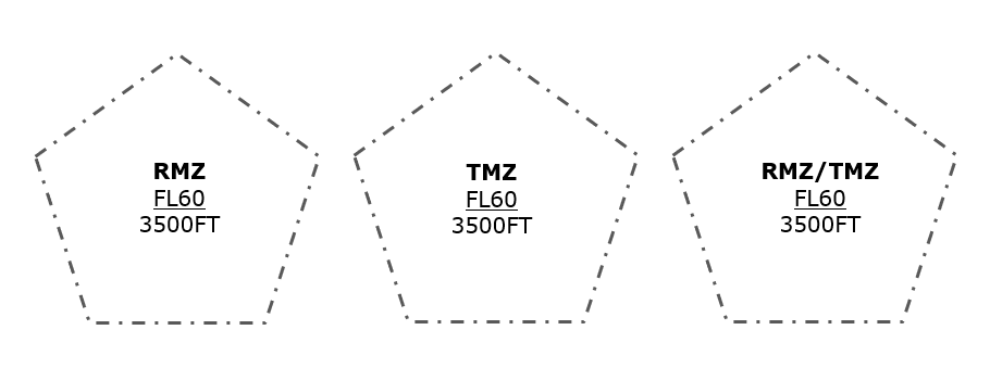
[applicable from 1 May 2025 - ED Decision 2024/006/R]
AIS.OR.330 NOTAM
Commission Implementing Regulation (EU) 2020/469
An AIS provider shall:
(a)promptly issue a NOTAM whenever the information to be distributed is of a temporary nature and of short duration or when operationally significant permanent changes, or temporary changes of long duration, are made at short notice, except for extensive text and/or graphics; and
(b)issue, as a NOTAM, information on the establishment, condition, or change of any aeronautical facility, service, procedure or hazard, the timely knowledge of which is essential to personnel involved with flight operations;
Compliance with point AIS.OR.200 shall not inhibit the urgent distribution of aeronautical information necessary to ensure the safety of flight.
GM1 AIS.OR.330(a) NOTAM
ED Decision 2020/008/R
SHORT DURATION / SHORT NOTICE
(a)The term ‘short duration’ should, in general, be understood as being less than 3 months.
(b)The term ‘short notice’ should be understood as insufficient time for the AIS provider to distribute an AIP supplement or amendment.
GM1 AIS.OR.330(b) NOTAM
ED Decision 2020/008/R
TIMELY KNOWLEDGE
It may be considered that the knowledge of the information is ‘timely’ if it reaches the personnel involved with flight operations in time to ensure the safety, regularity and efficiency of flight operations.
GM2 AIS.OR.330(b) NOTAM
ED Decision 2020/008/R
EXCEPTIONAL SITUATIONS
(a)It is recognised that, in the cases of NOTAM or digital NOTAM that are crucial to ensure the safety of flight, it is not always possible to comply with all the relevant provisions of the Regulation. However, it is also not possible to determine a priori all cases where this consideration may apply; this is dependent on a case-by-case individual assessment made by competent AIS staff.
(b)If it is determined that it is not possible to comply with all the relevant provisions of the Regulation, the NOTAM office ensures, at the minimum, that:
(1)the party originating the aeronautical data is authorised and/or an eligible/reasonable source;
(2)the content is plausible; and
(3)the DQRs are validated post publication, as soon as practicable.
Chapter 2 — Digital data sets
AIS.OR.335 General – Digital data sets
Commission Implementing Regulation (EU) 2020/469
If available, an AIS provider shall ensure that digital data is in the form of the following data sets:
(1)AIP data set;
(2)terrain data set;
(3)obstacle data sets;
(4)aerodrome mapping data sets; and
(5)instrument flight procedure data sets.
When made available, terrain data shall be provided in the form of terrain data sets. A checklist of valid data sets shall be regularly provided.
GM1 AIS.OR.335(a) General — Digital data sets
ED Decision 2020/008/R
DATA SETS
Data items may appear in multiple data sets.
AIS.OR.340 Metadata requirements
Commission Implementing Regulation (EU) 2020/469
Each data set shall include a minimum set of metadata to be provided to the next user.
AIS.OR.345 AIP data set
Commission Implementing Regulation (EU) 2020/469
An AIS provider shall ensure that the AIP data set, if available, contains the digital representation of aeronautical information of lasting character, including permanent information and long-duration temporary changes.
GM1 AIS.OR.345 AIP data set
ED Decision 2020/008/R
GENERAL
The purpose of the AIP data set is to support the initial transition of the ATM domain towards the use of digital data sets instead of paper products. Therefore, its scope is defined considering the likelihood that the data contained in this set is actually being used in digital format by service providers, air traffic control and instrument flight rules/visual flight rules airspace users.
AIS.OR.350 Terrain and obstacle data – General requirements
Commission Implementing Regulation (EU) 2020/469
An AIS provider shall ensure that terrain and obstacle data, if available, are provided in accordance with point AIS.TR.350.
GM1 AIS.OR.350 Terrain and obstacle data – General requirements
ED Decision 2020/008/R
GENERAL
(a)Useful information for those organisations involved in the origination, processing and provision of digital terrain and obstacle data, from the point at which the need for origination is identified through to the point when the Member State makes it available in accordance with the requirements of ICAO Annex 15, can be found in the EUROCONTROL ‘Terrain and Obstacle Data (TOD) Manual’ (edition 2.2, dated 28 November 2019).
(b)In addition, EUROCAE ED-98C ‘User Requirements For Terrain And Obstacle Data’ (October 2015) provides guidance for data gathering by data originators, for data processing by data integrators, for implementation by application integrators, and for end use by the aviation community (e.g. air carriers, air traffic services, procedure designers).
GM2 AIS.OR.350 Terrain and obstacle data – General requirements
ED Decision 2020/008/R
NAVIGATION APPLICATIONS
(a)Terrain and obstacle data are intended to be used in air navigation applications such as:
(1)ground proximity warning system with forward-looking terrain avoidance function and minimum safe altitude warning (MSAW) system;
(2)determination of contingency procedures for use in the event of an emergency during a missed approach or take-off;
(3)aircraft operating limitations analysis;
(4)instrument procedure design (including circling procedure);
(5)determination of en-route ‘drift-down’ procedure and en-route emergency landing location;
(6)advanced surface movement guidance and control system (A-SMGCS); and
(7)aeronautical chart production and on-board databases.
Additional information on the use of terrain and obstacle data can be found in Appendix C to EUROCAE ED-98C.
(b)The data may also be used in other applications such as flight simulator and synthetic vision systems, and may assist in determining the height restriction or removal of obstacles that pose a hazard to air navigation.
AIS.OR.355 Terrain data sets
Commission Implementing Regulation (EU) 2020/469
An AIS provider shall ensure that terrain data, if available, is provided:
(a)for Area 1, as laid down in point AIS.TR.350; and
(b)for aerodromes to cover:
(1)Area 2a or parts thereof, as laid down in point AIS.TR.350(b)(1);
(2)Areas 2b, 2c and 2d or parts thereof, as laid down in points AIS.TR.350(b)(2), (3) and (4), for terrain:
(i)within 10 km from the aerodrome reference point (ARP); and
(ii)beyond 10 km from the ARP if the terrain penetrates the horizontal plane 120 m above the lowest runway elevation;
(3)the take-off flight path area or parts thereof;
(4)an area, or parts thereof, bounded by the lateral extent of the aerodrome obstacle limitation surfaces;
(5)Area 3 or parts thereof, as laid down in point AIS.TR.350(c), for terrain that extends 0.5 m above the horizontal plane, passing through the nearest point on the aerodrome movement area; and
(6)Area 4 or parts thereof, as laid down in point AIS.TR.350(d), for all runways where precision approach Category II or III operations have been established and where detailed terrain information is required by operators to enable them to assess the effect of terrain on decision height determination by use of radio altimeters.
GM1 AIS.OR.355 Terrain data sets
ED Decision 2020/008/R
ADDITIONAL TERRAIN DATA
Where additional terrain data is collected to meet other aeronautical requirements, the terrain data sets may be expanded to include this additional data.
GM1 AIS.OR.355(b)(3) Terrain data sets
ED Decision 2020/008/R
TAKE-OFF FLIGHT PATH AREA
‘Take-off flight path area’ is defined in 3.8.2 of ICAO Annex 4.
GM1 AIS.OR.355(b)(4) Terrain data sets
ED Decision 2020/008/R
AERODROME OBSTACLE LIMITATION SURFACES
‘Aerodrome obstacle limitation surfaces’ are defined in Chapter H – Obstacle Limitation Surfaces of Regulation (EU) No 139/2014.
AIS.OR.360 Obstacle data sets
Commission Implementing Regulation (EU) 2020/469
An AIS provider shall ensure that obstacle data, if available, is provided:
(a)for obstacles in Area 1 whose height is 100 m or higher above ground;
(b)for aerodromes, for all obstacles within Area 2 that are assessed as being a hazard to air navigation; and
(c)for aerodromes, to cover:
(1)Area 2a or parts thereof, for those obstacles that penetrate the relevant obstacle data collection surface;
(2)objects in the take-off flight path area or parts thereof, which project above a plane surface having a 1,2 % slope and having a common origin with the take-off flight path area;
(3)penetrations of the aerodrome obstacle limitation surfaces or parts thereof;
(4)Areas 2b, 2c and 2d, for obstacles that penetrate the relevant obstacle data collection surfaces;
(5)Area 3 or parts thereof, for obstacles that penetrate the relevant obstacle data collection surface; and
(6)Area 4 or parts thereof, for all runways where precision approach Category II or III operations have been established.
GM1 AIS.OR.360 Obstacle data sets
ED Decision 2020/008/R
ADDITIONAL OBSTACLE DATA
Where additional obstacle data is collected to meet other aeronautical requirements, the obstacle data sets may be expanded to include this additional data.
AIS.OR.365 Aerodrome mapping data sets
Commission Implementing Regulation (EU) 2020/469
An AIS provider shall ensure that aerodrome mapping data sets, if available, are provided in accordance with point AIS.TR.365.
AIS.OR.370 Instrument flight procedure data sets
Commission Implementing Regulation (EU) 2020/469
An AIS provider shall ensure that instrument flight procedure data sets, if available, are provided in accordance with point AIS.TR.370.
SECTION 4 — DISTRIBUTION AND PRE-FLIGHT INFORMATION SERVICES
AIS.OR.400 Distribution services
Commission Implementing Regulation (EU) 2020/469
An AIS provider shall:
(a)distribute available aeronautical information products to those users who request them;
(b)make available the AIP, AIP amendments, AIP supplements, NOTAM and AIC by the most expeditious means;
(c)ensure that NOTAM are distributed through the aeronautical fixed service (AFS), whenever practicable;
(d)ensure that international exchange of NOTAM takes place only as mutually agreed between the international NOTAM offices and multinational NOTAM processing units concerned; and
(e)arrange, as necessary, the issuance and receipt of NOTAM distributed by telecommunication to satisfy operational requirements.
GM1 AIS.OR.400(a) Distribution services
ED Decision 2020/008/R
DELIVERY METHOD
(a)The distribution of available aeronautical information products to the intended users differs in the delivery method applied which may either be:
(1)physical distribution — the means by which aeronautical data and aeronautical information distribution is achieved through the delivery of a physical package, such as postal services; or
(2)direct electronic distribution — the means by which aeronautical data and aeronautical information distribution is achieved automatically through the use of a direct electronic connection between the AIS provider and the intended user.
(b)Different delivery methods and data media may require different procedures to ensure the required data quality.
(c)Further guidance on digital dataset distribution can be found in ICAO Doc 10039 ‘Manual on System Wide Information Management (SWIM) Concept’.
(d)Global communication networks and web services may be employed for the provision of aeronautical information products.
(e)Guidance to assist the AIS providers in developing and adapting their systems for the distribution of the State AIP on the internet as an official and authoritative source of information may be found in the EUROCONTROL ‘Guidelines for Aeronautical Information Publication (AIP) distribution on the Internet’ (edition 1.0, dated October 2017).
AIS.OR.405 Pre-flight information services
Commission Implementing Regulation (EU) 2020/469
An AIS provider shall ensure that:
(a)for any aerodrome/heliport, aeronautical information relative to the route stages originating at the aerodrome/heliport is made available to flight operations personnel, including flight crew and services responsible for pre-flight information; and
(b)aeronautical information provided for pre-flight planning purposes includes information of operational significance from the elements of the aeronautical information products.
GM1 AIS.OR.405(a) Pre-flight information services
ED Decision 2020/008/R
COMMUNICATION
Pre-flight information may be provided as a verbal briefing or a self-briefing.
GM1 AIS.OR.405(b) Pre-flight information services
ED Decision 2020/008/R
OPERATIONAL SIGNIFICANCE
(a)Geographic coverage for pre-flight information services should be determined and periodically reviewed. In general, the coverage zone should be limited to the flight information region (FIR) within which the aerodrome/heliport is located, the FIR(s) adjacent thereto, and all air route or portion of route flown without an intermediate landing, originating at the aerodrome/heliport and extending beyond the FIR(s) mentioned.
(b)The elements of the aeronautical information products may be limited to national publications and when practicable, those of immediately adjacent States, provided that a complete library of aeronautical information is available at a central location and means of direct communications with that library are available.
(c)A recapitulation of valid NOTAM of operational significance and other information of urgent character can be made available to flight crews in the form of plain-language pre-flight information bulletins (PIBs).
(d)Guidance on the preparation of pre-flight information services and PIBs may be found in Chapter 8 of ICAO Doc 8126 ‘Aeronautical Information Services Manual’ and in Chapter 7 of the EUROCONTROL ‘Guidelines — Operating Procedures for AIS Dynamic Data (OPADD)’ (edition:4.0, dated 17 April 2015).
SECTION 5 — AERONAUTICAL INFORMATION PRODUCTS UPDATES
AIS.OR.500 General – Aeronautical information products updates
Commission Implementing Regulation (EU) 2020/469
An AIS provider shall ensure that aeronautical data and aeronautical information are amended or reissued to keep them up to date.
AIS.OR.505 Aeronautical information regulation and control (AIRAC)
Commission Implementing Regulation (EU) 2020/469
An AIS provider shall ensure that information concerning the circumstances listed in point AIS.TR.505(a) is distributed under the AIRAC system.
An AIS provider shall ensure that:
(1)the information notified under the AIRAC system is not changed further for at least another 28 days after the AIRAC effective date unless the circumstance notified is of a temporary nature and would not persist for the full period;
(2)the information provided under the AIRAC system is distributed/made available so as to reach recipients at least 28 days in advance of the AIRAC effective date; and
(3)implementation dates other than the AIRAC effective dates are not used for pre-planned operationally significant changes requiring cartographic work and/or for updating of navigation databases.
GM1 AIS.OR.505 Aeronautical information regulation and control (AIRAC)
ED Decision 2020/008/R
AIRAC SYSTEM
Further explanations with regard to the application of the AIRAC system can be found in the EUROCONTROL ‘Procedure for the Assessment of Information for Notification by AIRAC’ (SDP/8), (edition 2.0, dated 17 July 2009). Additional details can be found in SDP/9, 10 and 13 for specific products.
AMC1 AIS.OR.505(2) Aeronautical information regulation and control (AIRAC)
ED Decision 2020/008/R
DISTRIBUTION
AIRAC information, distributed as a physical medium, should be sent at least 42 days in advance of the AIRAC effective dates with the objective of reaching recipients at least 28 days in advance of the effective date.
AIS.OR.510 NOTAM
Commission Implementing Regulation (EU) 2020/469
An AIS provider shall:
(a)ensure that NOTAM are provided in accordance with point AIS.TR.510; and
(b)provide a ‘trigger NOTAM’, as laid down in point AIS.TR.510(f), when an AIP amendment or an AIP supplement is published in accordance with AIRAC procedures.
AIS.OR.515 Data set updates
Commission Implementing Regulation (EU) 2020/469
An AIS provider shall:
(a)amend or reissue data sets at such regular intervals as may be necessary to keep them up to date; and
(b)issue permanent changes and temporary changes of long duration – three months or longer – made available as digital data in the form of a complete data set and/or a subset that includes only the differences from the previously issued complete data set.
AMC1 AIS.OR.515 Data set updates
ED Decision 2020/008/R
GENERAL
(a)When made available as a completely re-issued data set, the differences from the previously issued complete data set should be indicated.
(b)When temporary changes of short duration are made available as digital data, they should use the same information model as the complete data set.
SECTION 6 — PERSONNEL REQUIREMENTS
AIS.OR.600 General requirements
Commission Implementing Regulation (EU) 2020/469
In addition to point ATM/ANS.OR.B.005(a)(6) of Annex III, the AIS provider shall ensure that personnel responsible for the provision of aeronautical data and aeronautical information is:
(a)made aware of and applies the following:
(1)the requirements on aeronautical information products and services, as specified in Sections 2 to 5;
(2)the update cycles applicable to the issuing of AIP amendments and AIP supplements for the areas for which they provide aeronautical data or aeronautical information;
(b)adequately trained, competent and authorised for the job they are required to do.
GM1 AIS.OR.600(b) General requirements
ED Decision 2020/008/R
COMPETENCE
‘Competence’ is understood as a situation where the personnel responsible for originating aeronautical data and aeronautical information possess the required level of knowledge, technical and behavioural skills and experience, and language proficiency when required, in order to be authorised to perform their duties.
AUTHORISATION
The authorisation of personnel is usually granted by the AIS provider, but it might be granted by another entity depending on the national arrangements for managing the competence and performance of AIS personnel.
SUBPART B — TECHNICAL REQUIREMENTS FOR PROVIDERS OF AERONAUTICAL INFORMATION SERVICES (AIS.TR)
SECTION 2 — DATA QUALITY MANAGEMENT
AIS.TR.200 General
Commission Implementing Regulation (EU) 2020/469
(a)The accuracy of aeronautical data shall be as specified in the aeronautical data catalogue (‘data catalogue’), specified in Appendix 1 to Annex III (Part-ATM/ANS.OR).
(b)The resolution of aeronautical data shall be commensurate with the actual data accuracy.
(c)The integrity of aeronautical data shall be maintained. Based on the integrity classification specified in the data catalogue, procedures shall be put in place so that:
(1)for routine data, corruption is avoided throughout the processing of the data;
(2)for essential data, corruption does not occur at any stage of the entire process and additional processes are included, as needed, to address potential risks in the overall system architecture to further assure data integrity at this level;
(3)for critical data, corruption does not occur at any stage of the entire process and additional integrity assurance processes are included to fully mitigate the effects of faults identified by thorough analysis of the overall system architecture as potential data integrity risks.
(d)The traceability of aeronautical data shall be ensured.
(e)The timeliness of the aeronautical data shall be ensured, including any limits on the effective period of the data.
(f)The completeness of the aeronautical data shall be ensured.
(g)The format of delivered data shall be adequate to ensure that the data is interpreted in a manner that is consistent with its intended use.
GM1 AIS.TR.200(b) General
ED Decision 2020/008/R
ACCURACY — RESOLUTION
(a)The resolution of the data contained in the database may be the same or finer than the publication resolution.
(b)Stating that resolution needs to be commensurate with the accuracy means that digital data needs to have sufficient resolution to maintain accuracy. Typically, if an accuracy of .1 units is needed, then a resolution of 0.01 or .001 units would enable a data chain to preserve the accuracy without problems. A finer resolution could be misleading as one could assume that it supports a finer accuracy. This factor range of 10 to 100 between accuracy and resolution is applicable regardless of the units of measurements used.
AMC1 AIS.TR.200(d) General
ED Decision 2020/008/R
TRACEABILITY
Aeronautical data and associated metadata should be kept for a minimum period of 5 years beyond the validity period of the associated aeronautical information.
AIS.TR.210 Exchange of aeronautical data and aeronautical information
Commission Implementing Regulation (EU) 2020/469
Except for terrain data, the exchange format of aeronautical data shall:
(a)enable the exchange of data for both individual features and feature collections;
(b)enable the exchange of baseline information as a result of permanent changes;
(c)be structured in accordance with the subjects and properties of the aeronautical data catalogue, and be documented through a mapping between the exchange format and the aeronautical data catalogue.
AMC1 AIS.TR.210 Exchange of aeronautical data and aeronautical information
ED Decision 2020/008/R
EXCHANGE MODELS
(a)The exchange model used should encompass the aeronautical data and aeronautical information to be exchanged.
(b)The exchange model used should:
(1)use the unified modelling language (UML) to describe the aeronautical information features and their properties, associations and data types;
(2)include data value constraints and data verification rules;
(3)include provisions for metadata;
(4)include a temporality model to enable capturing the evolution of the properties of an aeronautical information feature during its life cycle;
(5)apply a commonly used data encoding format;
(6)cover all the features, attributes, data types and associations of the aeronautical information model; and
(7)provide an extension mechanism by which groups of users can extend the properties of existing features and add new features which do not adversely affect global standardisation.
GM1 to AMC1 AIS.TR.210 Exchange of aeronautical data and aeronautical information
ED Decision 2020/008/R
ENABLING EXCHANGE
(a)The intent of using a commonly used data encoding format is to ensure interoperability of aeronautical data exchange between agencies and organisations involved in the data processing chain.
(b)Examples of commonly used data encoding formats include extensible markup language (XML), geography markup language (GML), and JavaScript object notation (JSON).
AIS.TR.220 Verification
Commission Implementing Regulation (EU) 2020/469
(a)The verification shall ensure that:
(1)the aeronautical data was received without corruption;
(2)the aeronautical data process does not introduce corruption.
(b)Aeronautical data and aeronautical information entered manually shall be subject to independent verification to identify any errors that may have been introduced.
AIS.TR.225 Metadata
Commission Implementing Regulation (EU) 2020/469
The metadata to be collected shall include, as a minimum:
(a)the identification of the organisations or entities performing any action of originating, transmitting or manipulating the aeronautical data;
(b)the action performed;
(c)the date and time the action was performed.
AMC1 AIS.TR.225(a) Metadata
ED Decision 2020/008/R
IDENTIFICATION
The metadata collected should clearly identify the organisation or entity originating the data, as well as any organisation or entity introducing amendments to the data.
AMC1 AIS.TR.225(b) Metadata
ED Decision 2020/008/R
ACTION PERFORMED
The metadata reflecting each action performed involving origination or manipulation of the data should reflect any potential impact on the compliance with the applicable DQRs.
GM1 AIS.TR.225 Metadata
ED Decision 2020/008/R
GENERAL
Further explanation on the schema required for describing geographic information and services by means of metadata may be found in the:
(a)International Organization for Standardization, ISO 19115 — Geographic information — Metadata, Part I; and
(b)EUROCONTROL ‘Guidelines for the provision of Metadata to support the Exchange of Aeronautical Data’ (edition 1.0, dated 28 November 2019)
AIS.TR.235 Error reporting, error measurement and corrective actions
Commission Implementing Regulation (EU) 2020/469
The error reporting, error measurement and corrective mechanisms shall ensure that:
(a)problems identified during origination, production, storage, handling and processing, or those reported by users after publication, are recorded;
(b)all problems reported in relation to the aeronautical data and aeronautical information are analysed by the AIS provider and the necessary corrective actions are performed;
(c)priority is given to resolution of all errors, inconsistencies and anomalies detected in critical and essential aeronautical data;
(d)affected users are warned of errors by the most effective means, taking into account the integrity level of the aeronautical data and aeronautical information;
(e)error feedback is facilitated and encouraged.
AIS.TR.240 Data limitations
Commission Implementing Regulation (EU) 2020/469
The identification of data not meeting the DQRs shall be made with an annotation or by explicitly providing the quality value.
GM1 AIS.TR.240 Data limitations
ED Decision 2020/008/R
ANNOTATION
(a)The objective of such an annotation is to notify the users of the AIS products including their aeronautical data that specific quality requirements are not met and may, therefore, compel limitations in the operational use of the relevant aeronautical data.
(b)The following principles apply:
(1)the solution applies for both the eAIP and paper AIP;
(2)the use of the ‘asterisk’ is undesirable because it is already used for WGS-84 issues;
(3)the non-compliance covers all parts of the AIP, i.e. textual aeronautical data and charts; and
(4)non-compliant aeronautical data items shall be individually and explicitly identified and the use of any general statement with the intention of covering a range of data items shall be avoided.
(c)The AIP section GEN 1.7 is used to identify non-compliant aeronautical data items. A new sub-header should be introduced at the end of the current section named ‘Data non-compliant with European Commission Regulation (EU) 2017/373’.
(d)Within AIP GEN 1.7, the following two alternatives are proposed. The choice of which depends on national practicalities being based either on the amount of annotations to be published or on individual existing operational or technical constraints.
(1)Annotation alternative 1
Alternative 1 is recommended if the number of identified non-compliances covers no more than two AIP pages.
The relevant non-compliant data items shall be listed in a table, including as a minimum:
—specific data item;
—AIP section(s) concerned;
—reason for non-compliance;
—Notes/remarks.
Proposed table format:
Data Item | AIP section | Reason for non-compliance | Notes/remarks |
(2)Annotation alternative 2
Alternative 2 is recommended if the number of non-compliances extends more than two AIP pages. It should then contain a general (global) statement to indicate ‘Several data items are not compliant with the given regulation – details can be found online via <link>’. The link shall direct the user to a list on the website which must support compliance with minimum requirements: the list must be accessible online.
Note: The indication of ‘available on request’, or similar, is clearly insufficient. The list must be kept up to date and fully synchronised (consistent) with the AIP update cycles, as relevant. This list should be in the form of a table as indicated under alternative 1 noting that it will be made available to users as an extra element outside the AIP.
SECTION 3 — AERONAUTICAL INFORMATION PRODUCTS
AIS.TR.300 General – Aeronautical information products
Commission Implementing Regulation (EU) 2020/469
(a)Aeronautical information products intended for distribution shall include English text for those parts expressed in plain language, except those products intended to be distributed solely within a Member State.
(b)Place names shall be spelt in conformity with local usage and transliterated, when necessary, into the International Organization for Standardization (ISO) basic Latin alphabet.
(c)International Civil Aviation Organization (ICAO) abbreviations shall be used in the aeronautical information products whenever they are appropriate.
GM1 AIS.TR.300(b) General — Aeronautical information products
ED Decision 2020/008/R
PLACE NAMES
The phrase ‘when necessary’ means ‘for interoperability purposes’ e.g. in aeronautical information products that are intended to be processed by automated systems (NOTAM, data sets, etc.).
Chapter 1 – Aeronautical information in a standardised presentation
AIS.TR.305 Aeronautical information publication (AIP)
Commission Implementing Regulation (EU) 2020/469
(a)The AIP, AIP amendments and AIP supplements shall be provided as an ‘electronic AIP’ (eAIP). The eAIP shall allow for displaying on computer screen and printing on paper. In addition, the AIP, AIP amendments and AIP supplements may also be provided on paper.
(b)The AIP shall include:
(1)a statement of the competent authority responsible for the air navigation facilities, services or procedures covered by the AIP;
(2)the general conditions under which the services or facilities are available for use;
(3)a list of significant differences between the regulations and practices of the Member State and the related ICAO Standards and Recommended Practices (SAPRs) and Procedures;
(4)the choice made by a Member State in each significant case where an alternative course of action is provided for in the ICAO SARPs and procedures.
(c)The AIP shall contain information related to, and arranged under, the subject headings listed in Appendix 1.
(d)The issuing Member State and AIS provider shall be clearly indicated.
(e)When two or more Member States jointly provide an AIP, they shall be clearly indicated.
(f)Each AIP shall be self-contained and include a table of contents.
(g)An AIP shall be organised in three parts (GEN, ENR and AD), sections and subsections, except when the AIP, or a volume of the AIP, is designed to facilitate operational use in- flight, in which case the precise format and arrangement may be left to the discretion of the Member State provided that an adequate table of contents is included.
(h)Each AIP shall be dated.
(i)The date, consisting of the day, month (by name), and year, shall be the publication date and/or the effective date (AIRAC) of the information.
(j)When describing periods of activity, availability or operation, the applicable days and times shall be specified.
(k)Each AIP issued as a printed volume and each page of an AIP issued in a loose-leaf form shall be annotated to clearly indicate:
(1)the identity of the AIP;
(2)the territory covered and its subdivisions, when necessary;
(3)the identification of the issuing Member State and producing organisation (authority); and
(4)page numbers/chart titles.
(l)Any amendment to the printed volume of the AIP shall be made using replacement sheets.
AMC1 AIS.TR.305(a) Aeronautical information publication (AIP)
ED Decision 2020/008/R
ELECTRONIC FORM
The eAIP, eAIP amendments and eAIP supplements should be provided according to the EUROCONTROL ‘Specification for the Electronic Aeronautical Information Publication (eAIP)’ (edition 2.1, dated 6 October 2015).
AMC2 AIS.TR.305(a) Aeronautical information publication (AIP)
ED Decision 2020/008/R
ELECTRONIC AIP
When provided, the eAIP should be available on a physical distribution medium (CD, DVD, etc.) and/or online on the internet.
GM1 AIS.TR.305(a) Aeronautical information publication (AIP)
ED Decision 2020/008/R
PRINTED AIP
(a)A system of page numbering adaptable to the addition or deletion of sheets should be adopted. The page number should include:
(1)an identification of the part of the AIP;
(2)the section; and
(3)subsection, as applicable,
thus creating a separate set of numbers for each subject (e.g. GEN 2.1-3, ENR 4.1-1 or AD 2.2-3).
(b)If it is necessary by reason of bulk or for convenience, to publish an AIP in two or more parts or volumes, each of them will indicate that the remainder of the information is to be found in the other part(s) or volume(s).
(c)When the AIP is provided in more than one volume, each volume should include:
(1)a preface;
(2)a record of AIP amendments;
(3)a record of AIP supplements;
(4)a checklist of AIP pages; and
(5)a list of current hand amendments.
(d)When the AIP is published as one volume, the above-mentioned subsections should appear only in Part 1 — GEN and the annotation ‘not applicable’ should be entered against each of these subsections in Parts 2 and 3.
(e)The AIP should be published in loose-leaf form unless the complete publication is reissued at frequent intervals.
(f)Further guidelines for a harmonised AIP publication may be found in the EUROCONTROL ‘Guidelines for harmonised AIP publication and data set provision’ (edition 2.0, dated 23 May 2019).
AMC1 AIS.TR.305(c) Aeronautical information publication (AIP)
ED Decision 2022/015/R
INFORMATION PUBLISHED UNDER ‘AD 1.2.2 RUNWAY SURFACE CONDITION ASSESSMENT AND REPORTING, AND SNOW PLAN’
The following information, originated by the competent authority, should be published under AD 1.2.2 for all aerodromes open to public use in the State:
1.Organisation of the runway surface condition reporting and the winter service
An indication of the:
—organisation responsible for snow clearance and for assessing, improving and reporting runway surface conditions;
—general policy concerning operational priorities established for the clearance of movement areas;
—general policy concerning trend monitoring of surface friction characteristics, and what constitutes a complete survey.
2.Surveillance of movement areas
Indication of how surveillance of the movement areas is organised.
3.Surface condition assessment methods used; operations on specially prepared winter runways
Assessment methods and measurements taken. Reference should be made to the use of the runway condition assessment matrix, including the case of specially prepared winter runways, in the case the use of such runways has been approved.
4.Actions taken to maintain the usability of movement areas
A brief description of the methods used for clearing snow, slush, ice and standing water, e.g. plowing, sweeping or blowing, and details of any chemical methods employed for clearing movement areas. Information concerning when and how surface friction characteristics will be improved. General policy concerning coordination between aerodrome operators, air traffic services providers and the competent authorities to ensure compatibility between efficient snow clearance procedures and maximum utilisation of the aerodrome.
5.System and means of reporting
Reference should be made to the runway condition report.
6.The cases of runway closure
Indication of the general policy on closure of a runway.
7.Distribution of information about runway surface conditions
A short description of the system for distribution of information (NOTAM) for runways reaching the minimum friction value (slippery wet runways). Reference should be made to when NOTAMs for slippery wet runways are issued and updated.
A short description of the system for distribution of information about runway surface conditions (SNOWTAM, automatic terminal information service (ATIS) updating). Reference should be made to when SNOWTAMs are issued and updated. Furthermore, a description should be provided of how the upgraded/downgraded information is included in the SNOWTAM. In addition, a statement should be included when the information is disseminated with ATIS only.
AMC2 AIS.TR.305(c) Aeronautical information publication (AIP)
ED Decision 2022/015/R
INFORMATION PUBLISHED UNDER ‘AD 2.7 RUNWAY SURFACE CONDITION ASSESSMENT AND REPORTING AND SNOW PLAN’
The following information, originated by the respective aerodrome operator, should be published under AD 2.7.
(a)A reference to the content of AD.1.2.2 should be made for the runway surface condition assessment and reporting. Additional, aerodrome-specific information on runway surface condition assessment and reporting, complementing the information contained in AD 1.2.2 should be included.
(b)A detailed description of the equipment and operational priorities established for the clearance of aerodrome movement areas should be given, including:
1.Type(s) of clearing equipment
Indication as to whether the aerodrome is serviceable during all seasons of the year and, if not, the periods (months of the year) during which it may be unserviceable or must be used with caution, indicating the likely cause of unserviceability and the precautions to be taken. Information relating to snow removal should include:
(i)where no snow removal equipment is required, ‘Not applicable’ should be indicated;
(ii)where snow conditions exist, the types of equipment used should be indicated.
2.Clearance priorities
Indication of the priorities with regard to clearing of runway(s), taxiway(s) and apron(s).
3.Use of material for movement area surface treatment
Indication of the type of material used for movement area surface treatment, using the abbreviation/text or the material.
Where no material is used, ‘Not applicable’ should be indicated.
4.Specially prepared winter runways
Indication if specially prepared winter runways have been approved, including runway designators.
Where the use of specially prepared winter runways has not been approved, ‘Not applicable’ should be indicated.
5.Remarks
Any other relevant information not covered under this subsection.
AMC3 AIS.TR.305(c) Aeronautical information publication (AIP)
ED Decision 2022/015/R
INFORMATION FOR LED LIGHTS PUBLISHED UNDER ‘AD 2.14 APPROACH AND RUNWAY LIGHTING’
If the aerodrome operator provides information that light emitting diode (LED) lights are used as part of the approach and runway lighting system of the aerodrome, such information should be published in the ‘Remarks’. In such case, the information published should make clear, for each part of the lighting system, whether:
—LED lights are exclusively used for that part of the lighting system; or
—LED lights are used in combination with incandescent lights.
AMC4 AIS.TR.305(c) Aeronautical information publication (AIP)
ED Decision 2022/015/R
INFORMATION FOR VISUAL SEGMENT SURFACE (VSS) PENETRATION, PUBLISHED UNDER ‘AD 2.25’
If the VSS is penetrated, the information to be published under this section should clearly indicate the name of the affected procedure and the procedure minima affected.
The published information should be grouped per runway end.
In the case of no penetration, ‘Not applicable’ should be indicated.
GM1 AIS.TR.305(c) Aeronautical information publication (AIP)
ED Decision 2020/008/R
INFORMATION RELATED TO LOCATIONS
When listing locations, the city or town should be given in capital letters followed, where the facility is an aerodrome/heliport or is located at an aerodrome/heliport, by an oblique stroke and the name of the aerodrome/heliport in smaller capital letters or lower-case letters. Unless otherwise indicated, the list should be in alphabetical order.
GM2 AIS.TR.305(c) Aeronautical information publication (AIP)
ED Decision 2020/008/R
INFORMATION RELATED TO CHARTS, MAPS OR DIAGRAMS
(a)Charts, maps or diagrams should be used, when appropriate, to complement the AIP or serve as a substitute for the tabulations or text of the AIP.
(b)Where appropriate, charts produced in conformity with AIS.OR.325 may be used to fulfil this requirement.
GM3 AIS.TR.305(c) Aeronautical information publication (AIP)
ED Decision 2022/015/R
INFORMATION RELATED TO THE AIP DATA SET
When the AIP data set is provided, the following sections of the AIP may be left blank and a reference to the data set availability should be provided:
(a)ENR 2.1 FIR, UIR, TMA and CTA;
(b)ENR 3.1 Conventional navigation routes;
(c)ENR 3.2 Area navigation routes;
(d)ENR 3.3 Other routes;
(e)ENR 3.4 En route holding;
(f)ENR 4.1 Radio navigation aids — en route;
(g)ENR 4.4 Name-code designators for significant points;
(h)ENR 4.5 Aeronautical ground lights — en route;
(i)ENR 5.1 Prohibited, restricted and danger areas;
(j)ENR 5.2 Military exercise and training areas and air defence identification zone (ADIZ);
(k)ENR 5.3.1 Other activities of a dangerous nature;
(l)ENR 5.5 Aerial sporting and recreational activities;
(m)AD 2.17 Air traffic services airspace;
(n)AD 2.19 Radio navigation and landing aids;
(o)AD 3.16 Air traffic services airspace; and
(p)AD 3.18 Radio navigation and landing aids.
GM4 AIS.TR.305(c) Aeronautical information publication (AIP)
ED Decision 2020/008/R
INFORMATION RELATED TO THE OBSTACLE DATA SET
When the obstacle data set is provided, the following sections of the AIP may be left blank and a reference to the data set availability should be provided:
(a)ENR 5.4 Air navigation obstacles;
(b)AD 2.10 Aerodrome obstacles; and
(c)AD 3.10 Heliport obstacles.
GM5 AIS.TR.305(c) Aeronautical information publication (AIP)
ED Decision 2022/015/R
INFORMATION PUBLISHED REGARDING USE OF MATERIAL FOR MOVEMENT AREA SURFACE TREATMENT UNDER ‘AD 2.7 RUNWAY SURFACE CONDITION ASSESSMENT AND REPORTING AND SNOW PLAN’
The following list contains the abbreviations/words that may be published in the relevant section of the AIP regarding the use of material for movement area surface treatment, according to the information originated by the aerodrome operator:
(a)KAC, for potassium acetate fluids;
(b)KFOR, for potassium formate fluids;
(c)GAC, for glycerine acetate fluids;
(d)NAFO, for sodium formate solids;
(e)NAAC, for sodium acetate solids;
(f)EG, for ethylene glycol fluids;
(g)PG, for propylene glycol fluids;
(h)UREA; and
(i)SAND.
GM6 AIS.TR.305(c) Aeronautical information publication (AIP)
ED Decision 2022/015/R
INFORMATION FOR LED LIGHTS PUBLISHED UNDER ‘AD 2.14 APPROACH AND RUWNAY LIGHTING’
Examples of information published in the ‘Remarks’ indicating that light emitting diode (LED) lights are used as part of the approach and runway lighting system of the aerodrome, are shown below:
—‘RWY 05, LED and incandescent lights used as part of the RWY edge lights on both sides of RWY’;
—‘RWY 05, LED lights used for the centreline lighting system in the first 600 m; remaining length incandescent lights are used’;
—‘RWY 05, LED lights used in the full length of the approach lighting system’.
GM7 AIS.TR.305(c) Aeronautical information publication (AIP)
ED Decision 2022/015/R
INFORMATION FOR VISUAL SEGMENT SURFACE (VSS) PENETRATION, PUBLISHED UNDER ‘AD 2.25’
In case of VSS penetration, the information published under AD 2.25 is limited to the name of the affected procedure and procedure minima affected; information about the obstacles themselves penetrating the VSS is not published under ‘AD 2.25’, as such information is meant to be published under ‘AD 2.10 Aerodrome obstacles’.
GM8 AIS.TR.305(c) Aeronautical information publication (AIP)
ED Decision 2024/006/R
PUBLICATION OF RADIO MANDATORY ZONES (RMZs) AND TRANSPONDER MANDATORY ZONES (TMZs)
(a)The requirement to include a detailed description of RMZs and TMZs in the AIP, including in the relevant charts, should be met in a clear and unambiguous manner.
(b)The following illustrates the appropriate AIP sections where RMZ and TMZ information should be included:
(1)Section GEN 1.5 should contain any relevant information regarding aircraft equipment required for operations in RMZs and TMZs.
(2)Section ENR 2 should contain the information on RMZs and TMZs in the air traffic services airspace and other regulated airspace.
(3)Section ENR 6 should contain an en-route chart illustrating the RMZs and TMZs.
(4)Section AD 2 should contain the aerodrome-specific information, including the visual approach and area charts with the information on RMZs and TMZs.
[applicable from 1 May 2025 - ED Decision 2024/006/R]
AIS.TR.310 AIP amendments
Commission Implementing Regulation (EU) 2020/469
(a)Any operationally significant changes to the AIP, in accordance with point AIS.OR.505, shall be issued under AIRAC and clearly identified as such.
(b)Each AIP amendment shall be allocated a serial number, which shall be consecutive.
(c)When an AIP amendment is issued, it shall include references to the serial number of the NOTAM which have been incorporated into the amendment.
(d)The most current update cycles applicable to AIP amendments shall be made publicly available.
(e)Recourse to hand amendments/annotations shall be kept to a minimum; the normal method of amendment shall be by reissuing or by replacement of pages.
(f)Each AIP amendment shall:
(1)include a checklist with the current dates and numbers of each loose-leaf page in the AIP; and
(2)provide a recapitulation of any outstanding hand amendments.
(g)New or revised information shall be identified by an annotation against it in the margin.
(h)Each AIP amendment page, including the cover sheet, shall contain a publication date and, when applicable, an effective date.
(i)The regular intervals between the AIP amendments shall be specified in Part 1 – General (GEN) of the AIP.
AMC1 AIS.TR.310(g) AIP amendments
ED Decision 2020/008/R
ANNOTATION
(a)The annotation in the margin should be done by a thick black vertical line or, where the change incorporated covers one line only or a part of a line, a thick black horizontal arrow.
(b)For aeronautical charts, the annotation should be made as a marginal note.
GM1 AIS.TR.310(h) AIP amendments
ED Decision 2020/008/R
EFFECTIVE TIME
When an effective time other than 00.00 UTC is used, the effective time should also be indicated.
AIS.TR.315 AIP supplements
Commission Implementing Regulation (EU) 2020/469
(a)The AIP supplement issued in printed form shall be provided by means of distinctive pages.
(b)The most current update cycles applicable to AIP supplements shall be made publicly available.
(c)Each AIP supplement shall be allocated a serial number which shall be consecutive and based on the calendar year.
(d)Whenever an AIP supplement is issued as a replacement of a NOTAM, a reference to the series and number of the NOTAM shall be included.
(e)A checklist of valid AIP supplements shall be issued at intervals of not more than one month, as part of the checklist of NOTAM and also with distribution as for the AIP supplements.
(f)Each AIP supplement page shall have a publication date. Each AIRAC AIP supplement page shall have both a publication and an effective date.
GM1 AIS.TR.315 AIP supplements
ED Decision 2020/008/R
ISSUE OF NOTAM
When there is not sufficient time for the distribution of an AIP supplement, a NOTAM may be issued.
AIS.TR.320 Aeronautical information circular (AIC)
Commission Implementing Regulation (EU) 2020/469
(a)The AIC shall be provided as an electronic document.
(b)The AIC shall be provided whenever it is desirable to promulgate:
(1)forecasts of important changes in the air navigation procedures, services and facilities;
(2)forecasts of implementation of new navigational systems;
(3)significant information derived from aircraft accident/incident investigation which has a bearing on flight safety;
(4)information on regulations related to the safeguarding of civil aviation against acts of unlawful interference that jeopardise the security of civil aviation;
(5)advice on medical matters of special interest to pilots;
(6)warnings to pilots concerning the avoidance of physical hazards;
(7)information on the effect of certain weather phenomena on aircraft operations;
(8)information on new hazards affecting aircraft handling techniques;
(9)information on regulations related to the carriage of restricted articles by air;
(10)references to the requirements of national and EU legislation and to the publication of changes therein;
(11)information on aircrew licensing arrangements;
(12)information on training of aviation personnel;
(13)information on the implementation of, or exemption from, requirements in national and EU legislation;
(14)advice on the use and maintenance of specific types of equipment;
(15)the actual or planned availability of new or revised editions of aeronautical charts;
(16)information on the carriage of communication equipment;
(17)explanatory information related to noise abatement;
(18)selected airworthiness directives;
(19)information on changes in NOTAM series or distribution, new editions of AIP or major changes in their content, coverage or format;
(20)advance information on the snow plan; and
(21)other information of a similar nature.
(c)The AIC shall not be used for information that qualifies for inclusion in AIP or NOTAM.
(d)The snow plan issued in accordance with point AD 1.2.2 of the AIP shall be supplemented by seasonal information to be issued as an AIC well in advance of the beginning of each winter – not less than one month before the normal onset of winter conditions.
(e)When the AIC is selected by the originating Member State for distribution beyond its territory, it shall have the same distribution as the AIP.
(f)Each AIC shall be allocated a serial number which shall be consecutive and based on the calendar year.
(g)In the event that an AIC is provided in more than one series, each series shall be separately identified by a letter.
(h)A checklist of AIC currently in force shall be issued at least once a year, with distribution as for the AIC.
(i)A checklist of AIC provided beyond the territory of a Member State shall be included in the NOTAM checklist.
AMC1 AIS.TR.320(a) Aeronautical information circular (AIC)
ED Decision 2020/008/R
ELECTRONIC FORM
When AICs are provided as part of the ‘electronic AIP’, they should comply with the EUROCONTROL ‘Specification for the Electronic Aeronautical Information Publication (eAIP)’ (edition 2.1, dated 6 October 2015).
GM1 AIS.TR.320(a) Aeronautical information circular (AIC)
ED Decision 2020/008/R
PRINTED FORM
Differentiation and identification of AIC topics according to subjects using colour coding should be practised where the numbers of AICs in force are sufficient to make identification in this form necessary. For example:
(a)white — administrative;
(b)yellow — ATC;
(c)pink — safety;
(d)mauve — danger area map; and
(e)green — maps/charts.
GM1 AIS.TR.320(c) Aeronautical information circular (AIC)
ED Decision 2020/008/R
GENERAL
(a)AICs are not used to promulgate aeronautical data and aeronautical information that qualify for inclusion in AIP (including amendments and supplements) or in NOTAM. Nevertheless, AICs can be used to provide detailed information and/or interpretation about data contained in those aeronautical information products.
(b)Consequently:
(1)an AIC is not used to promulgate aeronautical data that is part of the data catalogue; and
(2)the content of an AIC is not subject to the application of the DQRs.
(c)AICs can be made available with the electronic AIP for distribution purpose, as long as it is understood that they remain separate aeronautical information products.
GM1 AIS.TR.320(d) Aeronautical information circular (AIC)
ED Decision 2020/008/R
SNOW PLAN INFORMATION
The seasonal AIC on the snow plan may contain information such as that listed below:
(a)a list of aerodromes/heliports where during the coming winter the following are expected to be performed:
(1)snow clearance in accordance with the runway and taxiway systems; or
(2)planned snow clearing, deviating from the runway system (length, width and number of runways, affected taxiways and aprons or portions thereof);
(b)information concerning any centre designated to coordinate information on the current state of progress of clearance and on the current state of runways, taxiways and aprons;
(c)a division of the aerodromes/heliports into SNOWTAM distribution lists in order to avoid excessive NOTAM distribution;
(d)an indication, as necessary, of minor changes to the standing snow plan;
(e)a descriptive list of clearance equipment; and
(f)a listing of what will be considered as the minimum critical snow bank to be reported at each aerodrome/heliport at which reporting will commence.
AIS.TR.330 NOTAM
Regulation (EU) 2024/403
(a)A NOTAM shall be issued when it is necessary to provide the following information:
(1)establishment of, closure of, or significant changes in the operation of aerodromes or heliports or runways;
(2)establishment of, withdrawal of, and significant changes in, the operation of aeronautical services;
(3)establishment of, withdrawal of, and significant changes in, the operational capability of radio navigation and air-ground communication services;
(4)unavailability of backup and secondary systems, having a direct operational impact;
(5)establishment of, withdrawal of, or significant changes to, visual aids;
(6)interruption of, or return to operation of, major components of aerodrome lighting systems;
(7)establishment of, withdrawal of, or significant changes to, procedures for air navigation services;
(8)occurrence or correction of major defects or impediments in the manoeuvring area;
(9)changes to, and limitations on, the availability of fuel, oil and oxygen;
(10)major changes to search and rescue (SAR) facilities and services available;
(11)establishment of, withdrawal of, or return to, operation of hazard beacons marking obstacles to air navigation;
(12)changes in regulations applicable in the Member State(s) concerned that require immediate action from an operational perspective;
(13)operational directives requiring immediate action or changes thereto;
(14)presence of hazards that affect air navigation;
(15)planned laser emissions, laser displays and search lights if pilots’ night vision is likely to be impaired;
(16)erecting or removal of, or changes to, obstacles to air navigation in the take-off/climb, missed approach, approach areas as well as on the runway strip;
(17)establishment or discontinuance of, including activation or deactivation, as applicable, or changes in, the status of prohibited, restricted or danger areas;
(18)establishment or discontinuance of areas or routes, or portions thereof, where the possibility of interception exists and where the maintenance of guard on the very high frequency (VHF) emergency frequency 121.500 MHz is required;
(19)allocation, cancellation or change of location indicators;
(20)changes in aerodrome/heliport rescue and firefighting (RFF) category;
(21)presence of, removal of, or significant changes in, hazardous conditions due to snow, slush, ice, radioactive material, toxic chemicals, volcanic ash deposition or water on the movement area;
(22)outbreaks of epidemics necessitating changes in notified requirements for inoculations and quarantine measures;
(23)forecasts of solar cosmic radiation, where provided;
(24)an operationally significant change in volcanic activity, the location, date and time of volcanic eruptions and/or the horizontal and vertical extent of a volcanic ash cloud, including direction of movement, flight levels and routes or portions of routes that could be affected;
(25)(release into the atmosphere of radioactive materials or toxic chemicals following a nuclear or chemical incident, the location, date and time of the incident, the flight levels and routes, or portions thereof, that could be affected, as well as the direction of movement;
(26)establishment of operations of humanitarian relief missions, together with procedures and/or limitations that affect air navigation;
(27)implementation of short-term contingency measures in cases of disruption, or partial disruption, of ATS and related supporting services;
(28)specific loss of integrity of satellite-based navigation systems.
(29)unavailability of a runway due to runway marking works or, if the equipment used for those works can be removed, a time lag required for making the runway available.’
(b)A NOTAM shall not be issued to provide any of the following information:
(1)routine maintenance work on aprons and taxiways that does not affect the safe movement of aircraft;
(2)temporary obstructions in the vicinity of aerodromes/heliports that do not affect the safe operation of aircraft;
(3)partial failure of aerodrome/heliport lighting facilities where such failure does not directly affect aircraft operations;
(4)partial temporary failure of air-ground communications when suitable alternative frequencies are available and are operative;
(5)lack of apron marshalling services, road traffic closures, limitations and control;
(6)the unserviceability of location, destination or other instruction signs on the aerodrome movement area;
(7)parachuting when in uncontrolled airspace under visual flight rules (VFR), or when in controlled airspace at promulgated sites or within danger or prohibited areas;
(8)training activities performed by ground units;
(9)unavailability of backup and secondary systems if these do not have an operational impact;
(10)limitations to airport facilities or general services, with no operational impact;
(11)national regulations not affecting general aviation;
(12)announcements or warnings about possible/potential limitations, with no operational impact;
(13)general reminders on already published information;
(14)availability of equipment for ground units, without information on the operational impact on airspace and facility users;
(15)information about laser emissions with no operational impact and about fireworks below the minimum flying heights;
(16)closure of parts of the movement area in connection with locally coordinated, planned work of duration of less than one hour;
(17)closure, changes, unavailability in the operation of aerodrome(s)/heliport(s) other than in the aerodrome(s)/ heliport(s) operation hours; and
(18)other non-operational information of a similar temporary nature.
(c)Except as provided for in points AIS.TR.330(f) and AIS.TR.330(g), each NOTAM shall contain the information in the order shown in the NOTAM format of Appendix 2.
(d)NOTAM text shall be composed of the significations/uniform abbreviated phraseology assigned to the ICAO NOTAM Code, complemented by ICAO abbreviations, indicators, identifiers, designators, call signs, frequencies, figures and plain language.
(e)All NOTAM shall be issued in English language. If necessary for domestic users, NOTAM may additionally be issued in national language.
(f)Information concerning snow, slush, ice, frost, standing water or water associated with snow, slush, ice or frost on the movement area shall be disseminated by means of SNOWTAM and shall contain the information in the order shown in the SNOWTAM format of Appendix 3a.
[applicable until 30 April 2025 - Regulation (EU) 2020/469]
(f)Information concerning snow, slush, ice, frost, standing water or water associated with snow, slush, ice or frost on the movement area shall be disseminated by means of SNOWTAM and shall contain the information in the order shown in the SNOWTAM format of Appendix 3.
[applicable from 1 May 2025 - Regulation (EU) 2024/403]
(g)Information concerning an operationally significant change to volcanic activity, volcanic eruption and/or volcanic ash cloud shall, when reported by means of an ASHTAM, contain the information in the order shown in the ASHTAM format of Appendix 4.
(h)When errors occur in a NOTAM, a NOTAM with a new number shall be issued to replace the erroneous NOTAM or the erroneous NOTAM shall be cancelled and a new NOTAM shall be issued.
(i)When a NOTAM is issued that cancels or replaces a previous NOTAM:
(1)the series and number/year of the previous NOTAM shall be indicated;
(2)the series, location indicator and subject of both NOTAM shall be the same.
(j)Only one NOTAM shall be cancelled or replaced by a NOTAM.
(k)Each NOTAM shall deal with only one subject and one condition of the subject.
(l)Each NOTAM shall be as brief as possible and compiled so that its meaning is clear without the need to refer to another document.
(m)A NOTAM containing permanent or temporary information of long duration shall include appropriate references to the AIP or AIP supplement.
(n)Location indicators included in the text of a NOTAM shall be those contained in ICAO Doc 7910 ‘Location Indicators’. A curtailed form of such indicators shall not be used. Where no ICAO location indicator is assigned to the location, its place name shall be entered in plain language.
(o)A series identified by a letter and a four-digit number followed by a stroke and a two-digit number for the year shall be allocated to each NOTAM. The four-digit number shall be consecutive and based on the calendar year.
(p)All NOTAM shall be divided in series based on subject, traffic or location or a combination thereof, depending on end-user needs. NOTAM for aerodromes allowing international air traffic shall be issued in international NOTAM series.
(q)If NOTAM are issued in both English and national language, the NOTAM series shall be organised so that the national language series are equivalent to the English language series in terms of content and numbering.
(r)The content and geographical coverage of each NOTAM series shall be stated in detail in the AIP, in point GEN 3.
(s)A checklist of valid NOTAM shall be regularly provided.
(t)One checklist NOTAM shall be issued for each series.
(u)A checklist NOTAM shall also refer to the latest AIP amendments, AIP supplements, data sets and, at least, to distributed AIC.
(v)A checklist NOTAM shall have the same distribution as the actual message series to which it refers and shall be clearly identified as a checklist.
(w)Series allocation shall be monitored and, if required, appropriate measures shall be taken to assure that no series reaches the maximum possible number of issued NOTAM before the end of a calendar year.
AMC1 AIS.TR.330 NOTAM
ED Decision 2020/008/R
USE OF OPADD
The origination and issuing of NOTAM should be in accordance with the EUROCONTROL ‘Guidelines — Operating Procedures for AIS Dynamic Data (OPADD)’ (edition 4.0, dated 17 April 2015).
GM1 AIS.TR.330(d) NOTAM
ED Decision 2020/008/R
NOTAM CODE
The ICAO NOTAM Code together with significations/uniform abbreviated phraseology, and ICAO Abbreviations are those contained in ICAO Doc 8400 ‘Procedures for Air Navigation Services — ICAO Abbreviations and Codes (PANS-ABC)’.
GM1 AIS.TR.330(u) NOTAM
ED Decision 2020/008/R
CHECKLIST
The checklist NOTAM may include the checklist of AIP Supplement (SUP).
Chapter 2 — Digital data sets
AIS.TR.335 General— Digital data sets
Commission Implementing Regulation (EU) 2020/469
(a)A standard for geographic information shall be used as a reference framework.
(b)A description of each available data set shall be provided in the form of a data product specification.
(c)A checklist of the available data sets, including their effective and publication dates, shall be made available to users to ensure that current data is being used.
(d)The checklist of data sets shall be made available through the same distribution mechanism as the one used for the data sets.
GM1 AIS.TR.335(a) General — Digital data sets
ED Decision 2020/008/R
STANDARD FOR GEOGRAPHIC INFORMATION
The ISO 19100 series of standards for geographic information may be used as a reference framework.
GM1 AIS.TR.335(b) General — Digital data sets
ED Decision 2020/008/R
DATA PRODUCT SPECIFICATION
(a)ISO Standard 19131 specifies the requirements and outline of data product specifications for geographic information. This is intended to facilitate and support the use and exchange of digital data sets between data providers and data users.
(b)The data product specification enables air navigation users to evaluate the products and determine whether they fulfil the requirements for their intended use (application).
(c)This may include an overview, specification scope, data product identification, data content and structure, reference system, data quality, data capture, data maintenance, data portrayal, data product delivery, additional information, and metadata.
AIS.TR.340 Metadata requirements
Commission Implementing Regulation (EU) 2020/469
The minimum metadata for each data set shall include:
(a)the name of the organisations or entities providing the data set;
(b)the date and time when the data set was provided;
(c)the validity of the data set; and
(d)any limitations on the use of the data set.
AIS.TR.345 AIP data set
Commission Implementing Regulation (EU) 2020/469
(a)The AIP data set shall include data about the following subjects, including the properties indicated, if applicable:
Data subjects | Associated properties as a minimum |
ATS airspace | Type, name, lateral limits, vertical limits, class of airspace |
Special activity airspace | Type, name, lateral limits, vertical limits, restriction, activation |
Route | Identifier prefix, flight rules, designator |
Route segment | Navigation specification, start point, end point, track, distance, upper limit, lower limit, minimum en-route altitude (MEA), minimum obstacle clearance altitude (MOCA), direction of cruising level, reverse direction of cruising level, required navigation performance |
Waypoint – en-route | Reporting requirement, identification, location, formation |
Aerodrome/heliport | Location indicator, name, International Air Transport Association (IATA) designator, served city, certification date, certification expiration date, if applicable, control type, field elevation, reference temperature, magnetic variation, airport reference point |
Runway | Designator, nominal length, nominal width, surface type, strength |
Runway direction | Designator, true bearing, threshold, take-off run available (TORA), take-off distance available (TODA), accelerate-stop distance available (ASDA), landing distance available (LDA), rejected TODA (for helicopters) |
Final approach and take-off area (FATO) | Designation, length, width, threshold point |
Touchdown and lift-off area (TLOF) | Designator, centre point, length, width, surface type |
Radio navigation aid | Type identification, name, aerodrome served, hours of operation, magnetic variation, frequency/channel, position, elevation, magnetic bearing, true bearing, zero bearing direction |
(b)When a property is not defined for a particular occurrence of the subjects listed in (a), the AIP data subset shall include an explicit indication: ‘not applicable’.
GM1 AIS.TR.345(b) AIP data set
ED Decision 2020/008/R
PROPERTY
There may also be other reasons why a property is not provided, e.g. missing, unknown, withheld, etc.
AIS.TR.350 Terrain and obstacle data – General requirements
Commission Implementing Regulation (EU) 2020/469
The coverage areas for sets of terrain and obstacle data shall be specified as:
(a)Area 1: the entire territory of a Member State;
(b)Area 2: within the vicinity of an aerodrome, subdivided as follows:
(1)Area 2a: a rectangular area around a runway which comprises the runway strip plus any clearway that exists;
(2)Area 2b: an area extending from the ends of Area 2a in the direction of departure, with a length of 10 km and a splay of 15 % to each side;
(3)Area 2c: an area extending outside Areas 2a and 2b at a distance of not more than 10 km from the boundary of Area 2a; and
(4)Area 2d: an area outside Areas 2a, 2b and 2c up to a distance of 45 km from the aerodrome reference point, or to an existing terminal manoeuvring area (TMA) boundary, whichever is nearer;
(c)Area 3: the area bordering an aerodrome movement area which extends horizontally from the edge of a runway to 90 m from the runway centre line and 50 m from the edge of all other parts of the aerodrome movement area; and
(d)Area 4: the area extending 900 m prior to the runway threshold and 60 m to each side of the extended runway centre line in the direction of the approach on a precision approach runway, Category II or III.
GM1 AIS.TR.350(d) Terrain and obstacle data — General requirements
ED Decision 2020/008/R
AREA 4
Where the terrain at a distance greater than 900 m (3 000 ft) from the runway threshold is mountainous or otherwise significant, the length of Area 4 should be extended to a distance not exceeding 2 000 m (6 500 ft) from the runway threshold.
AIS.TR.355 Terrain data sets
Commission Implementing Regulation (EU) 2020/469
When terrain data sets are provided in accordance with point AIS.OR.355:
(a)terrain data sets shall contain the digital representation of the terrain surface in the form of continuous elevation values at all intersections of a defined grid, referenced to a common datum;
(b)a terrain grid shall be angular or linear and shall be of a regular or irregular shape;
(c)terrain data sets shall include spatial (position and elevation), thematic, and temporal aspects of the surface of the Earth, containing naturally occurring features, excluding obstacles;
(d)only one feature type, i.e. terrain, shall be provided;
(e)the following terrain feature attributes shall be recorded in the terrain data set:
(1)area of coverage;
(2)identification of the data originator er;
(3)data source identifier;
(4)acquisition method;
(5)post spacing;
(6)horizontal reference system;
(7)horizontal resolution;
(8)horizontal accuracy;
(9)horizontal confidence level;
(10)horizontal position;
(11)elevation;
(12)elevation reference;
(13)vertical reference system;
(14)vertical resolution;
(15)vertical accuracy;
(16)vertical confidence level;
(17)recorded surface;
(18)integrity;
(19)date and time stamp; and
(20)unit of measurement used;
(f)Within the area covered by a 10-km radius from the ARP, terrain data shall comply with the Area 2 numerical requirements;
(g)in the area between 10 km and the TMA boundary or a 45-km radius, whichever is smaller, data on terrain that penetrates the horizontal plane 120 m above the lowest runway elevation shall comply with the Area-2 numerical requirements;
(h)in the area between 10 km and the TMA boundary or a 45-km radius, whichever is smaller, data on terrain that does not penetrate the horizontal plane 120 m above the lowest runway elevation shall comply with the Area-1 numerical requirements; and
(i)in those portions of Area 2 where flight operations are prohibited due to very high terrain or other local restrictions and/or regulations, terrain data shall comply with the Area-1 numerical requirements.
Terrain data collection surfaces – Area 1 and Area 2
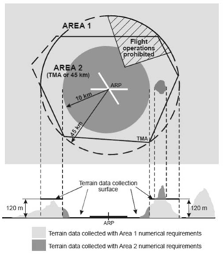
GM1 AIS.TR.355(e) Terrain data sets
ED Decision 2020/008/R
ATTRIBUTES
The following additional terrain feature attributes may be recorded in the terrain data set:
(a)surface type;
(b)penetration level; and
(c)known variations.
AIS.TR.360 Obstacle data sets
Commission Implementing Regulation (EU) 2020/469
When obstacle data sets are provided in accordance with point :
(a)obstacle data items are features that shall be represented in the data sets by points, lines or polygons;
(b)all defined obstacle feature types shall be provided and each of them shall be described according to the following list of attributes:
(1)area of coverage;
(2)identification of the data originator;
(3)data source identifier;
(4)obstacle identifier;
(5)horizontal accuracy;
(6)horizontal confidence level;
(7)horizontal position;
(8)horizontal resolution;
(9)horizontal extent;
(10)horizontal reference system;
(11)elevation;
(12)vertical accuracy;
(13)vertical confidence level;
(14)vertical resolution;
(15)vertical reference system;
(16)obstacle type;
(17)geometry type;
(18)integrity;
(19)date and time stamp;
(20)unit of measurement used;
(21)lighting; and
(22)marking;
(c)obstacle data for Areas 2 and 3 shall be collected in accordance with the following obstacle collection surfaces:
(1)the Area 2a obstacle collection surface has a height of 3 m above the nearest runway elevation measured along the runway centre line, and for those portions related to a clearway, if one exists, at the elevation of the nearest runway end;
(2)the Area 2b obstacle collection surface has a 1,2 % slope extending from the ends of Area 2a at the elevation of the runway end in the direction of departure, with a length of 10 km and a splay of 15 % to each side; obstacles less than 3 m in height above the ground need not be collected;
(3)the Area 2c obstacle collection surface has a 1,2 % slope extending outside Areas 2a and 2b at a distance of not more than 10 km from the boundary of Area 2a; the initial elevation of Area 2c shall be the elevation of the point of Area 2a at which it commences; obstacles less than 15 m in height above the ground need not be collected;
(4)the Area 2d obstacle collection surface has a height of 100 m above the ground; and
(5)the Area 3 obstacle collection surface extends 0.5 m above the horizontal plane passing through the nearest point on the aerodrome movement area;
(d)in those portions of Area 2 where flight operations are prohibited due to very high terrain or other local restrictions and/or regulations, obstacle data shall be collected and recorded in accordance with the Area 1 numerical requirements;
(e)the obstacle data product specification, supported by geographical coordinates for each aerodrome included within the dataset, shall describe the following areas:
(1)Areas 2a, 2b, 2c and 2d;
(2)the take-off flight path area; and
(3)the obstacle limitation surfaces;
(f)obstacle data sets shall contain the digital representation of the vertical and horizontal extent of the obstacles; and
(g)obstacles shall not be included in terrain data sets.
Obstacle data collection surfaces – Area 1 and Area 2
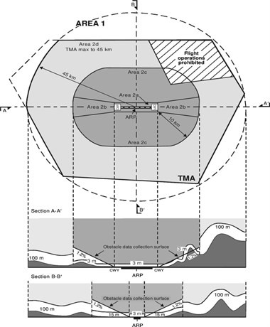
GM1 AIS.TR.360(b) Obstacle data sets
ED Decision 2020/008/R
ATTRIBUTES
The following additional obstacle feature attributes may be recorded in the obstacle data set:
(a)height;
(b)operations; and
(c)effectiveness.
AIS.TR.365 Aerodrome mapping data sets
Commission Implementing Regulation (EU) 2020/469
(a)Aerodrome mapping data sets shall contain the digital representation of aerodrome features.
(b)ISO standards for geographic information shall be used as a reference framework.
(c)Aerodrome mapping data products shall be described following the relevant data product specification standard.
(d)The content and structure of aerodrome mapping data sets shall be defined in terms of an application schema and a feature catalogue
GM1 AIS.TR.365 Aerodrome mapping data sets
ED Decision 2020/008/R
ADDITIONAL GUIDANCE
Further information concerning minimum requirements and reference material applicable to the content, origination, publication, and updating of aerodrome mapping information may be found in EUROCAE ED-99D ‘User Requirement for Aerodrome Mapping Information’, October 2015, and EUROCAE ED-119C ‘Interchange Standards for Terrain, Obstacle and Aerodrome Mapping Data’, October 2015.
GM1 AIS.TR.365(a) Aerodrome mapping data sets
ED Decision 2020/008/R
AERODROME FEATURES
Aerodrome features consist of attributes and geometries, which are characterised as points, lines or polygons. Examples include runway thresholds, taxiway guidance lines and parking stand areas.
GM2 AIS.TR.365(a) Aerodrome mapping data sets
ED Decision 2020/008/R
ADDITIONAL DATA
Aerodrome mapping data may be supported by electronic terrain and obstacle data for Area 3 in order to ensure consistency and quality of all geographical data related to the aerodrome.
GM3 AIS.TR.365(a) Aerodrome mapping data sets
ED Decision 2020/008/R
COMMON ACQUISITION TECHNIQUES
Electronic terrain and obstacle data pertaining to Area 3 as well as aerodrome mapping data may be originated using common acquisition techniques and managed within a single geographic information system (GIS).
GM1 AIS.TR.365(b) Aerodrome mapping data sets
ED Decision 2020/008/R
GENERAL
ISO Standard 19100 series on geographic information can be used as a reference framework.
GM1 AIS.TR.365(c) Aerodrome mapping data sets
ED Decision 2020/008/R
GENERAL
ISO Standard 19131 contains standards for data product specification.
GM1 AIS.TR.365(d) Aerodrome mapping data sets
ED Decision 2020/008/R
GENERAL
ISO Standard 19109 contains standards for application schemas, while ISO Standard 19110 describes the feature cataloguing methodology for geographic information.
AIS.TR.370 Instrument flight procedure data sets
Commission Implementing Regulation (EU) 2020/469
(a)Instrument flight procedure data sets shall contain the digital representation of instrument flight procedures.
(b)The instrument flight procedure data sets shall include data about the following subjects, including all of their properties:
(1)procedure;
(2)procedure segment;
(3)final approach segment;
(4)procedure fix;
(5)procedure holding;
(6)helicopter procedure specifics.
GM1 AIS.TR.370 Instrument flight procedure data sets
ED Decision 2020/008/R
GENERAL
Guidance on the instrument flight procedure data sets can be found in PANS-OPS, ICAO Doc 8168, Volume II – Part III, Section 2, Chapter 5.
SECTION 4 — DISTRIBUTION SERVICES
AIS.TR.400 Distribution services
Commission Implementing Regulation (EU) 2020/469
(a)A predetermined distribution system for NOTAM transmitted on the AFS shall be used whenever possible.
(b)Distribution of NOTAM series other than those distributed internationally shall be granted upon request.
(c)NOTAM shall be prepared in conformity with ICAO communication procedures laid down in ICAO Annex 10, Volume II.
(d)Each NOTAM shall be transmitted as a single telecommunication message.
(e)The exchange of ASHTAM beyond the territory of a Member State, and NOTAM where Member States use NOTAM for distribution of information on volcanic activity, shall include volcanic ash advisory centres and the world area forecast centres, and take account of the requirements of long-range operations.
GM1 AIS.TR.400(a) Distribution services
ED Decision 2020/008/R
NOTAM
(a)The predetermined distribution system provides for incoming NOTAM (including SNOWTAM and ASHTAM) to be channelled through the aeronautical fixed service (AFS) directly to designated addressees predetermined by the receiving country concerned while concurrently being routed to the international NOTAM office for checking and control purposes.
(b)The addressee indicators for those designated addressees are constituted as follows:
(1)First and second letters
The first two letters of the location indicator for the AFS communication centre associated with the relevant international NOTAM office of the receiving country.
(2)Third and fourth letters
The letters ‘ZZ’ indicating a requirement for special distribution.
(3)Fifth letter
The fifth letter differentiating between NOTAM (letter ‘N’), SNOWTAM (letter ‘S’), and ASHTAM (letter ‘V’).
(4)Sixth and seventh letters
The sixth and seventh letters, each taken from the series A to Z, denoting the national and/or international distribution list(s) to be used by the receiving AFS centre.
The fifth, sixth and seventh letters replace the three-letter designator YNY which, in the normal distribution system, denotes an international NOTAM office.
(5)Eighth letter
The eighth position letter shall be the filler letter ‘X’ to complete the eight-letter addressee indicator.
(c)Member States are to inform the States from which they receive NOTAM of the sixth and seventh letters to be used under different circumstances to ensure proper routing.
AIS.TR.405 Pre-flight information services
Commission Implementing Regulation (EU) 2020/469
(a)Automated pre-flight information systems shall be used to make aeronautical data and aeronautical information available to operations personnel, including flight crew members, for self-briefing, flight planning and flight information service purposes.
(b)The human machine interface of the pre-flight information services facilities shall ensure easy access to all relevant information/data in a guided manner.
(c)Self-briefing facilities of an automated pre-flight information system shall provide access, as necessary, to the aeronautical information service for consultation by telephone or other suitable telecommunication means.
(d)Automated pre-flight information systems for the supply of aeronautical data and aeronautical information for self-briefing, flight planning and flight information service shall:
(1)provide for continuous and timely updating of the system database and monitoring of the validity and quality of the aeronautical data stored;
(2)permit access to the system by operations personnel, including flight crew members, aeronautical personnel concerned and other aeronautical users, through suitable telecommunications means;
(3)ensure the provision of the aeronautical data and aeronautical information accessed, in paper form, as required;
(4)use access and interrogation procedures based on abbreviated plain language and ICAO location indicators laid down in ICAO Doc 7910, as appropriate, or based on a menu-driven user interface or other appropriate mechanism;
(5)provide a timely response to a user request for information.
(e)All NOTAM shall be made available for briefing by default, and content reduction shall be at user’s discretion.
GM1 AIS.TR.405(a) Pre-flight information services
ED Decision 2020/008/R
AUTOMATION
(a)Automated pre-flight information systems that provide a harmonised, common point of access by operations personnel, including flight crew members and other aeronautical personnel concerned, to aeronautical information and meteorological information should be established by an agreement between the AIS provider and the meteorological services provider.
(b)Where automated pre-flight information systems are used to provide the harmonised, common point of access by operations personnel, including flight crew members and other aeronautical personnel concerned, to aeronautical data, aeronautical information and meteorological information, the AIS provider remains responsible for the quality and timeliness of the aeronautical data and aeronautical information provided by means of such a system.
(c)The meteorological services provider concerned remains responsible for the quality of the meteorological information provided by means of such a system in accordance with Annex V to Regulation (EU) 2017/373.
GM1 AIS.TR.405(e) Pre-flight information services
ED Decision 2020/008/R
NOTAM
Although NOTAM with purpose ‘M’ are regarded not subject for a briefing but available on request, all NOTAM are to be provided for briefing by default, and content reduction should be at user’s discretion.
SECTION 5 — AERONAUTICAL INFORMATION PRODUCTS UPDATES
AIS.TR.500 General – Aeronautical information products updates
Commission Implementing Regulation (EU) 2020/469
The same AIRAC cycle update shall be applied to the AIP amendments, AIP supplements, AIP data set and the instrument flight procedure data sets in order to ensure consistency of the data items that appear in multiple aeronautical information products.