

Filters
AMC1 MET.TR.235 Aerodrome warnings and wind shear warnings and alerts
ED Decision 2022/004/R
AERODROME WARNINGS — TEMPLATE FOR AERODROME WARNINGS
(a)Aerodrome warnings should be issued in accordance with the template below or in another format where required by operators or aerodrome meteorological offices.
Template for aerodrome warnings Key: M=inclusion mandatory; C=inclusion conditional, included whenever applicable. Note 1: The ranges and resolutions for the numerical elements included in aerodrome warnings are provided in GM1 MET.TR.235. Note 2: The row numbers in the ‘Ref.’ column are included only for clarity and ease of reference, and are not part of the aerodrome warning. | |||
Ref. | Element | Detailed content | Templates |
1 | Location indicator of the aerodrome (M) | Location indicator of the aerodrome | nnnn |
2 | Identification of the type of message (M) | Type of message and sequence number | AD WRNG [n]n |
3 | Validity period (M) | Day and time of validity period in UTC | VALID nnnnnn/nnnnnn |
4 | IF THE AERODROME WARNING IS TO BE CANCELLED, SEE DETAILS AT THE END OF THE TEMPLATE. | ||
5 | Phenomenon (M) | Description of the phenomenon causing the issuance of the aerodrome warning | TC nnnnnnnnnn or [HVY] TS or GR or [HVY] SN [nnCM] or [HVY] FZRA or [HVY] FZDZ or RIME or [HVY] SS or [HVY] DS or SA or DU or SFC WSPD nn[n]KT MAX nn[n] or SFC WIND nnn/nn[n]KT MAX nn[n] or SQ or FROST or TSUNAMI or VA[DEPO] or TOX CHEM or Free text up to 32 characters |
6 | Observed or forecast phenomenon (M) | Indication whether the information is observed and expected to continue, or forecast | OBS [AT nnnnZ] or FCST |
7 | Changes in intensity (C) | Expected changes in intensity | INTSF or WKN or NC |
OR | |||
8 | Cancellation of the aerodrome warning | Cancellation of the aerodrome warning referring to its identification | CNL AD WRNG [n]n nnnnnn/nnnnnn |
(b)When the above template is used, the sequence number referred to in the template should correspond to the number of aerodrome warnings issued for the aerodrome since 00.01 UTC on the day concerned.
GM1 MET.TR.235 Aerodrome warnings and wind shear warnings and alerts
ED Decision 2022/004/R
RANGES AND RESOLUTIONS — AERODROME WARNINGS
(a)The ranges and resolutions for the numerical elements included in aerodrome warnings are shown below:
Ranges and resolutions for the numerical elements included in volcanic ash and tropical cyclone advisories, SIGMET, AIRMET, aerodrome and wind shear warnings Note: The row numbers in the ‘Ref.’ column are included only for clarity and ease of reference, and are not part of the template. | |||
Ref. | Elements | Range | Resolution |
1 | Summit elevation:FT | 000–27 000 | 1 |
M | 000–8 100 | 1 | |
2 | Advisory number:for VA (index)* | 000–2 000 | 1 |
for TC (index)* | 00–99 | 1 | |
3 | Maximum surface wind: KT | 00–199 | 1 |
4 | Central pressure:hPa | 850–1 050 | 1 |
5 | Surface wind speed:KT | 30–99 | 1 |
6 | Surface visibility:M | 0000–0750 | 50 |
M | 0800–5 000 | 100 | |
7 | Cloud: height of base:FT | 000–1 000 | 100 |
8 | Cloud: height of top: FT | 000–9 900 | 100 |
FT | 10 000–60 000 | 1 000 | |
9 | Latitudes:° (degrees) | 00–90 | 1 |
(minutes) | 00–60 | 1 | |
10 | Longitudes:° (degrees) | 000–180 | 1 |
(minutes) | 00–60 | 1 | |
11 | Flight levels: | 000–650 | 10 |
12 | Movement:KT | 0–150 | 5 |
KMH | 0–300 | 10 | |
* Non-dimensional | |||
(b)The explanations for the abbreviations can be found in ICAO Doc 8400 'Procedures for Air Navigation Services — ICAO Abbreviations and Codes (PANS-ABC)'.
GM2 MET.TR.235 Aerodrome warnings and wind shear warnings and alerts
ED Decision 2022/004/R
AERODROME WARNINGS — EXAMPLES OF ELEMENTS
Non-exhaustive examples of the different elements used in the formulation of aerodrome warnings are provided below.
Aerodrome warning — examples of elements Note 1: Consult the ‘aerodrome warning’ template in AMC1 MET.TR.235 to identify the mandatory (M), the conditional (C) or the optional (O) elements. Note 2: The ranges and resolutions for the numerical elements included in aerodrome warnings are provided in GM1 MET.TR.235. Note 3: The row numbers in the ‘Ref.’ column are included only for clarity and ease of reference, and are not part of the aerodrome warning. They do not correlate with the ‘Ref.’ column in | ||
Ref. | Element | Examples |
1 | Location indicator of the aerodrome | YUCC |
2 | Identification of the type of message | AD WRNG 2 |
3 | Validity period | VALID 211230/211530 |
4 | IF THE AERODROME WARNING IS TO BE CANCELLED, SEE DETAILS AT THE END OF THE TEMPLATE. | |
5 | Phenomenon | TC ANDREW HVY SN 25CM SFC WSPD 40KT MAX 60 SFC WIND 230/40KT VA TSUNAMI |
6 | Observed or forecast phenomenon | OBS AT 1200Z OBS |
7 | Changes in intensity | WKN |
OR | ||
8 | Cancellation of the aerodrome warning | CNL AD WRNG 2 211230/211530 |
GM3 MET.TR.235 Aerodrome warnings and wind shear warnings and alerts
ED Decision 2022/004/R
Phenomenon (M) — TOX CHEM
When issuing an aerodrome warning due to information related to toxic chemical affecting an aerodrome and or volcanic ash deposition, the warning should be filed by means of the use of free text up to 32 characters, e.g. TOX CHEM FCST XXXX AIRPORT NEARBY WKN. (XXXX = ICAO Location Indicator)
AMC1 MET.TR.235(a) Aerodrome warnings and wind shear warnings and alerts
ED Decision 2020/008/R
AERODROME WARNINGS — FORMAT
(a)The additional text should be prepared in abbreviated plain language using approved ICAO abbreviations and numerical values. If no ICAO-approved abbreviations are available, English plain language text should be used.
(b)When quantitative criteria are necessary for the issuance of aerodrome warnings, the criteria used should be as agreed between the aerodrome meteorological office and the users concerned.
AMC1 MET.TR.235(c) Aerodrome warnings and wind shear warnings and alerts
ED Decision 2022/004/R
WIND SHEAR WARNINGS - FORMAT
(a)The use of text in addition to the abbreviations listed in the template in Appendix 4 should be kept to a minimum. The additional text should be prepared in abbreviated plain language using ICAO-approved abbreviations and numerical values.
(b)When an aircraft report is used to prepare a wind shear warning or to confirm a warning previously issued, the corresponding aircraft report, including the aircraft type, should be disseminated unchanged in accordance with the local arrangements to those concerned.
GM1 MET.TR.235(a) Aerodrome warnings and wind shear warnings and alerts
ED Decision 2020/008/R
WIND SHEAR TYPES
Following reported encounters by both arriving and departing aircraft, two different wind shear warnings may exist: one for arriving aircraft and one for departing aircraft.
GM2 MET.TR.235(a) Aerodrome warnings and wind shear warnings and alerts
ED Decision 2020/008/R
REPORTING THE INTENSITY OF WIND SHEAR
Specifications for reporting the intensity of wind shear are still under development. It is recognised, however, that pilots, when reporting wind shear, may use the qualifying terms ‘moderate’, ‘strong’ or ‘severe’, based to a large extent on their subjective assessment of the intensity of the wind shear encountered.
GM1 MET.TR.235(c) Aerodrome warnings and wind shear warnings and alerts
ED Decision 2020/008/R
DETECTION OF WIND SHEAR
Wind shear conditions are normally associated with the following phenomena:
(a)thunderstorms, microbursts, funnel cloud, tornado or waterspout, and gust fronts;
(b)frontal surfaces;
(c)strong surface winds coupled with local topography;
(d)sea breeze fronts;
(e)mountain waves, including low-level rotors in the terminal area;
(f)low-level temperature inversions.
GM1 MET.TR.235(d) Aerodrome warnings and wind shear warnings and alerts
ED Decision 2017/001/R
DISSEMINATION OF WIND SHEAR ALERTS
The wind shear alerts are disseminated from automated, ground-based, wind shear remote-sensing or detection equipment in accordance with local arrangements to those concerned.
Chapter 3 — Technical requirements for meteorological watch offices
MET.TR.250 SIGMET
Regulation (EU) 2021/1338
(a)SIGMET shall be issued in accordance with the template shown in Appendix 5.
(b)SIGMET shall consist of three types:
(1)SIGMET for en-route weather phenomena other than volcanic ash or tropical cyclones;
(2)SIGMET for volcanic ash;
(3)SIGMET for tropical cyclones.
(c)The sequence number of SIGMET shall consist of three characters comprising one letter and two numbers.
(d)Only one of the phenomena listed in Appendix 5 shall be included in a SIGMET, using the appropriate abbreviations and the following threshold value of surface wind speed of 34 kt or more for tropical cyclones.
(e)SIGMET concerning thunderstorms or a tropical cyclone shall not include references to associated turbulence and icing.
AMC1 MET.TR.250(a) SIGMET
ED Decision 2020/008/R
AIRSPACE
In cases where the airspace is divided into a flight information region (FIR) and an upper-flight information region (UIR), the SIGMET should be identified by the location indicator of the ATS unit serving the FIR.
AMC2 MET.TR.250(a) SIGMET
ED Decision 2022/004/R
SIGMET — CODE FORM
SIGMET, and cancellations thereof, should be encoded using:
(a)the IWXXM GML form as specified in point (a) of AMC1 MET.TR.115(a);
(b)abbreviated plain language as specified in point (c) of AMC1 MET.TR.115(a).
AMC3 MET.TR.250(a) SIGMET
ED Decision 2022/004/R
FORMAT
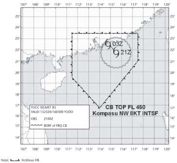
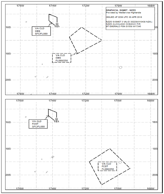
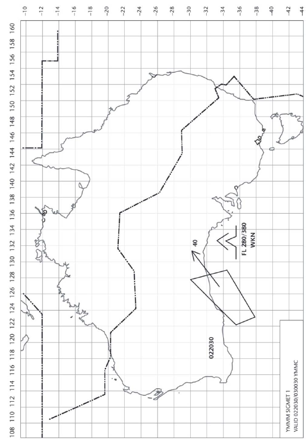
SIGMET, when issued in graphical format, should be as specified below:
(a)SIGMET FOR TROPICAL CYCLONE — MODEL STC
(b)SIGMET FOR VOLCANIC ASH — MODEL SVA, MERCATOR PROJECTION
(c)SIGMET FOR VOLCANIC ASH — MODEL SVA, POLAR STEREOGRAPHIC PROJECTION

(d)SIGMET FOR PHENOMENA OTHER THAN TROPICAL CYCLONES AND VOLCANIC ASH — MODEL SGE
AMC4 MET.TR.250(a) SIGMET
ED Decision 2022/004/R
COORDINATION WITH NEIGHBOURING METEOROLOGICAL WATCH OFFICES (MWOs)
An MWO should coordinate SIGMET with neighbouring MWO(s), especially when the en-route weather phenomenon extends or is expected to extend beyond the MWO’s specified area of responsibility, to ensure harmonised SIGMET provision.
GM1 MET.TR.250(a) SIGMET
ED Decision 2020/008/R
FLIGHT INFORMATION REGION
The SIGMET applies to the whole airspace within the lateral limits of the FIR, i.e. to the FIR and to the UIR. The particular areas and/or flight levels affected by the meteorological phenomena causing the issuance of the SIGMET are given in the text of the message.
GM2 MET.TR.250(a) SIGMET
ED Decision 2020/008/R
EXAMPLE OF SIGMET, AND THE CORRESPONDING CANCELLATIONS
SIGMET YUDD SIGMET T02 VALID 101200/101600 YUSO– YUDD SHANLON FIR/UIR OBSC TS FCST S OF N54 AND E OF W012 TOP FL390 MOV E 20 KT WKN |
Cancellation of SIGMET YUDD SIGMET T03 VALID 101345/101600 YUSO– YUDD SHANLON FIR/UIR CNL SIGMET T02 101200/101600 |
GM3 MET.TR.250(a) SIGMET
ED Decision 2020/008/R
EXAMPLE OF SIGMET FOR TROPICAL CYCLONE
YUCC SIGMET CO3 VALID 251600/252200 YUDO — YUCC AMSWELL FIR TC GLORIA PSN N2706 W07306 CB OBS AT 1600Z WI 250NM OF TC CENTRE TOP FL500 NC FCST AT 2200Z TC CENTRE PSN N2740 W07345 Meaning: The third tropical cyclone SIGMET issued for the AMSWELL* flight information region (identified by YUCC Amswell area control centre) by the Donlon/International* meteorological watch office (YUDO) since 0001 UTC; the SIGMET is valid from 16.00 UTC to 22.00 UTC on the 25th of the month; tropical cyclone Gloria at 27 degrees 6 minutes north and 73 degrees 6 minutes west; cumulonimbus was observed at 16.00 UTC within 250 nautical miles of the centre of the tropical cyclone with top at flight level 500; no changes in intensity are expected; at 22.00 UTC, the centre of the tropical cyclone is forecast to be located at 27 degrees 40 minutes north and 73 degrees 45 minutes west * Fictitious locations |
GM4 MET.TR.250(a) SIGMET
ED Decision 2020/008/R
EXAMPLE OF SIGMET FOR VOLCANIC ASH
YUDD SIGMET AO2 VALID 101200/101800 YUSO– YUDD SHANLON FIR VA ERUPTION MT ASHVAL PSN N4315 E02115 VA CLD OBS AT 1200Z WI N4315 E02115 - N4345 E02145 – N4330 E02215 – N4245 E02230 - N4230 E02145 - N4315 E02115 FL250/370 WKN FCST AT 1800Z NO VA EXP= Meaning: The second volcanic ash SIGMET issued for the SHANLON* flight information region (identified by YUDD Shanlon area control centre/upper flight information region) by the Shanlon/International* meteorological watch office (YUSO) since 00.01 UTC; the SIGMET is valid from 12.00 UTC to 18.00 UTC on the 10th of the month; volcanic ash eruption of Mount Ashval* located at 43 degrees 15 minutes north and 21 degrees 15 minutes east; volcanic ash cloud observed at 12.00 UTC within an area bounded by 43 degrees 15 minutes north and 21 degrees 15 minutes east to 43 degrees 30 minutes north and 22 degrees 15 minutes east to 42 degrees 45 minutes north and 22 degrees 30 minutes east to 42 degrees 30 minutes north and 21 degrees 45 minutes east to 43 degrees 15 minutes north and 21 degrees 15 minutes east between flight levels 250 and 370, weakening, and forecast at 18.00 UTC to have dissipated with no volcanic ash expected. * Fictitious locations |
GM5 MET.TR.250(a) SIGMET
ED Decision 2022/004/R
EXAMPLE OF SIGMET FOR RADIOACTIVE CLOUD
YUCC SIGMET RO2 VALID 201200/201600 YUDO — YUCC AMSWELL FIR RDOACT CLD OBS AT 1155Z WI 30KM OF N6030 E02550 SFC/FL550 STNR Meaning: The second radioactive cloud SIGMET issued for the AMSWELL* flight information region (identified by YUCC Amswell area control centre) by the Donlon/International* meteorological watch office (YUDO) since 0001 UTC; the SIGMET is valid from 12.00 UTC to 16.00 UTC on the 20th of the month; radioactive cloud was observed at 1155 UTC within 30 kilometres of 60 degrees 30 minutes north 25 degrees 50 minutes east between the surface and flight level 550. The radioactive cloud is stationary. * Fictitious locations |
GM6 MET.TR.250(a) SIGMET
ED Decision 2020/008/R
EXAMPLE OF SIGMET FOR SEVERE TURBULENCE
YUCC SIGMET U05 VALID 221215/221600 YUDO— YUCC AMSWELL FIR SEV TURB OBS AT 1210Z N2020 W07005 FL250 MOV E 20KT WKN FCST 1600Z S OF N2020 E OF W06950 Meaning: The fifth severe turbulence SIGMET issued for the AMSWELL* flight information region (identified by YUCC Amswell area control centre) by the Donlon/International* meteorological watch office (YUDO) since 0001 UTC; the SIGMET is valid from 12.15 UTC to 16.00 UTC on the 22nd of the month; severe turbulence was observed at 1210 UTC 20 degrees 20 minutes north and 70 degrees 5 minutes west at flight level 250; the turbulence is expected to move eastwards at 20 knots and to strengthen in intensity; at 16.00 UTC, the severe turbulence is forecast to be located south of 20 degrees 20 minutes north and east of 69 degrees 50 minutes west. * Fictitious locations |
GM7 MET.TR.250(a) SIGMET
ED Decision 2022/004/R
COORDINATION WITH NEIGHBOURING METEOROLOGICAL WATCH OFFICES (MWOs)
Guidance on the bilateral or multilateral coordination between MWOs of neighbouring States for the provision of SIGMET can be found in ICAO EUR Doc 014 ‘EUR SIGMET and AIRMET Guide’.
AMC1 MET.TR.250(c) SIGMET
ED Decision 2022/004/R
SEQUENCE NUMBER
(a)The three-character sequence number should be constructed using a single letter identifying the phenomenon, followed by two numeric characters corresponding to the number of SIGMET issued for that phenomenon for the specified flight information region since 00.01 UTC on the day concerned.
(b)The letters to be used as the first character for the SIGMET sequence number to indicate the specified en-route weather and other phenomena for which the SIGMET has been issued should be:
SIGMET Type | Specified en-route phenomena | Letter to be used in the sequence number for specified en-route phenomena |
WC | Tropical cyclone | C |
For WC exchange test purposes | X | |
WV | Volcanic ash | A |
For WV exchange test purposes | Y | |
WS | Thunderstorm | T |
Turbulence | U | |
Icing | I | |
Freezing rain | F | |
Mountain wave | M | |
Dust storm | D | |
Sandstorm | S | |
Radioactive cloud | R | |
For WS exchange test purposes | Z |
(c)When SIGMET is issued for test purposes (‘TEST’ status indicator used in the SIGMET), then the appropriate letter for exchange test purposes should be used, i.e. ‘Y’ for a TEST volcanic ash SIGMET. When SIGMET is issued for exercise purposes (‘EXER’ status indicator used in the SIGMET), then the letter chosen should correspond to that used under normal circumstances, i.e. ‘A’ for a SIGMET issued during a volcanic ash exercise.
AMC1 MET.TR.250(d) SIGMET
ED Decision 2020/008/R
CRITERIA RELATED TO PHENOMENA
Sandstorm/dust storm should be considered:
(a)heavy whenever the visibility is below 200 m and the sky is obscured; and
(b)moderate whenever the visibility is:
(1)below 200 m and the sky is not obscured; or
(2)between 200 and 600 m.
GM1 MET.TR.250(d) SIGMET
ED Decision 2022/004/R
CRITERIA RELATED TO PHENOMENA
(a)An area of thunderstorms and cumulonimbus clouds is considered:
(1)obscured (OBSC) if it is obscured by haze or smoke or cannot be readily seen due to darkness;
(2)embedded (EMBD) if it is embedded within cloud layers and cannot be readily recognised;
(3)isolated (ISOL) if it consists of individual features which affect, or are forecast to affect, an area with a maximum spatial coverage less than 50 % of the area concerned (at a fixed time or during the period of validity); and
(4)occasional (OCNL) if it consists of well-separated features which affect, or are forecast to affect, an area with a maximum spatial coverage between 50 and 75 % of the area concerned (at a fixed time or during the period of validity).
(b)An area of thunderstorms is considered frequent (FRQ) if within that area there is little or no separation between adjacent thunderstorms with a maximum spatial coverage greater than 75 % of the area affected, or forecast to be affected, by the phenomenon (at a fixed time or during the period of validity).
(c)Squall line (SQL) indicates a thunderstorm along a line with little or no space between individual clouds.
(d)Hail (GR) is used as a further description of the thunderstorm, as necessary.
(e)Severe and moderate turbulence (TURB) refers only to: low-level turbulence associated with strong surface winds; rotor streaming; or turbulence whether in cloud or not (CAT). Turbulence is not used in connection with convective clouds.
(f)Turbulence is considered:
(1)severe whenever the peak value of the EDR equals or exceeds 0.45; and
(2)moderate whenever the peak value of the EDR is equal to or above 0.20 and below 0.45.
(g)Severe and moderate icing (ICE) refers to icing in other than convective clouds. Freezing rain (FZRA) should refer to severe icing conditions caused by freezing rain.
(h)A mountain wave (MTW) is considered:
(1)severe whenever an accompanying downdraft of 600 ft/min (3.0 m/s) or more and/or severe turbulence is observed or forecast; and
(2)moderate whenever an accompanying downdraft of 350–600 ft/min (1.75–3.0 m/s) and/or moderate turbulence is observed or forecast.
MET.TR.255 AIRMET
Regulation (EU) 2021/1338
(a)AIRMET shall be issued in accordance with the template shown in Appendix 5.
(b)The sequence number referred to in the template in Appendix 5 shall correspond to the number of AIRMET issued for the flight information region since 00.01 UTC on the day concerned.
(c)Only one of the phenomena in Appendix 5 shall be included in an AIRMET, using the appropriate abbreviations and the following threshold values, when the phenomenon is below flight level 100, or below flight level 150 in mountainous areas, or higher, where necessary:
(1)widespread surface wind speed above 30 kt with relevant direction and units;
(2)widespread areas affected by reduction of visibility to less than 5 000 m, including the weather phenomenon causing the reduction of visibility;
(3)widespread areas of broken or overcast cloud with height of base less than 1 000 ft above ground level’.
(d)AIRMET concerning thunderstorms or cumulonimbus clouds shall not include references to associated turbulence and icing.
AMC1 MET.TR.255(a) AIRMET
ED Decision 2022/004/R
AIRMET — CODE FORM
AIRMET, and cancellations thereof, should be encoded using:
(a)the IWXXM GML form as specified in point (a) of AMC1 MET.TR.115(a);
(b)abbreviated plain language as specified in point (c) of AMC1 MET.TR.115(a).
GM1 MET.TR.255(a) AIRMET
ED Decision 2020/008/R
EXAMPLE OF AIRMET FOR MODERATE MOUNTAIN WAVE
YUCC AIRMET 2 VALID 221215/221600 YUDO — YUCC AMSWELL FIR MOD MTW OBS AT 1205Z N48 E010 FL080 STNR NC Meaning: The second AIRMET issued for the AMSWELL* flight information region (identified by YUCC Amswell area control centre) by the Donlon/International* meteorological watch office (YUDO) since 00.01 UTC; the AIRMET is valid from 12.15 UTC to 16.00 UTC on the 22nd of the month; moderate mountain wave was observed at 1205 UTC at 48 degrees north and 10 degrees east at flight level 080; the mountain wave is expected to remain stationary and not to undergo any changes in intensity. * Fictitious locations |
GM2 MET.TR.255(a) AIRMET
ED Decision 2020/008/R
EXAMPLE OF AIRMET, AND THE CORRESPONDING CANCELLATIONS
AIRMET YUDD AIRMET 1 VALID 151520/151800 YUSO– YUDD SHANLON FIR ISOL TS OBS N OF S50 TOP ABV FL100 STNR WKN |
Cancellation of AIRMET YUDD AIRMET 2 VALID 151650/151800 YUSO– YUDD SHANLON FIR CNL AIRMET 1 151520/151800 |
GM1 MET.TR.255(b) AIRMET
ED Decision 2020/008/R
FIR
The flight information region may be divided in sub-areas.
GM1 MET.TR.255(c) AIRMET
ED Decision 2020/008/R
CRITERIA RELATED TO PHENOMENA
In reference to the criteria related to phenomena, please refer to GM1 MET.TR.250(d).
AMC1 MET.TR.255(d) AIRMET
ED Decision 2020/008/R
CRITERIA RELATED TO PHENOMENA
In reference to sandstorm/dust storm, please refer to AMC1 MET.TR.250(d).
MET.TR.260 Area forecasts for low-level flights
Regulation (EU) 2021/1338
(a)When chart form is used for area forecasts for low-level flights, the forecast of upper wind and upper-air temperature shall be issued for points separated by no more than 300 NM and for, as a minimum, the following altitudes: 2 000, 5 000 and 10 000 ft (600, 1 500 and 3 000 m) and 15 000 ft (4 500 m) in mountainous areas. The issuance of forecasts of upper wind and upper-air temperature at an altitude of 2 000 ft (600 m) may be subject to local orographic considerations as determined by the competent authority.
(b)When chart form is used for area forecasts for low-level flights, the forecast of SIGWX phenomena shall be issued as low-level SIGWX forecast for flight levels up to 100, or up to flight level 150 in mountainous areas, or higher, where necessary. Low-level SIGWX forecasts shall include:
(1)the following phenomena warranting the issuance of a SIGMET: severe icing, severe turbulence, cumulonimbus clouds and thunderstorms that are obscured, frequent, embedded or occurring at a squall line, sandstorms/dust storms and volcanic eruptions or a release of radioactive materials into the atmosphere, and which are expected to affect low-level flights;
(2)the following elements in area forecasts for low-level flights: surface wind, surface visibility, significant weather phenomena, mountain obscuration, cloud, icing, turbulence, mountain wave and height of zero-degree isotherm.
(c)When the competent authority has determined that the density of traffic operating below flight level 100, or up to flight level 150 in mountainous areas, or higher, where necessary, warrants the issuance of an AIRMET in combination with area forecasts for low-level flights, the area forecasts shall be issued to cover the layer between the ground and flight level 100, or up to flight level 150 in mountainous areas, or higher, where necessary, and shall contain information on en-route weather phenomena hazardous to low-level flights.
AMC1 MET.TR.260 Area forecasts for low-level flights
ED Decision 2022/004/R
AMENDMENT OF AREA FORECASTS FOR LOW-LEVEL FLIGHTS
(a)In case that an area forecast for low-level flights is not issued in combination with AIRMET, the criteria for amendments to the area forecast for low-level flights should as a minimum include the weather phenomena hazardous to low-level flights, which would otherwise constitute the criteria for the issuance of AIRMET.
(b)When low-level forecast is issued as a SIGWX chart or as a wind and temperature (W+T) chart, it should, as appropriate, include the cloud/visibility information in the form of visibility/cloud base category which should be provided for well-defined sub-areas and/or route segments. For each sub-area and/or route segment, the reference height to which the cloud base information refers should be specified.
(c)The graphical part of a SIGWX chart should depict the weather situation at the beginning of the validity period. Significant changes of initial weather parameters should be depicted together with time intervals determining the duration of expected changes.
Chapter 4 — Technical requirements for volcanic ash advisory centres (VAACs)
MET.TR.265 Volcanic ash advisory centre responsibilities
Regulation (EU) 2021/1338
The advisory information on volcanic ash shall be issued in accordance with the template shown in Appendix 6. When no abbreviations are available, English plain language text, to be kept to a minimum, shall be used.
AMC1 MET.TR.265 Volcanic ash advisory centre responsibilities
ED Decision 2022/004/R
VOLCANIC ASH ADVISORY — CODE FORM
Volcanic ash advisory should be disseminated using:
(a)the IWXXM GML form as specified in point (a) of AMC1 MET.TR.115(a);
(b)abbreviated plain language as specified in point (c) of AMC1 MET.TR.115(a).
AMC2 MET.TR.265 Volcanic ash advisory centre responsibilities
ED Decision 2022/004/R
VOLCANIC ASH ADVISORY INFORMATION — GRAPHICAL FORMAT
The volcanic ash advisory information listed in Appendix 6 to Annex V (Part-MET) to Regulation (EU) 2017/373, when prepared in graphical format, should be as specified below and issued using the portable network graphics (PNG) format as specified in point (f) of
AMC1 MET.TR.115(a):
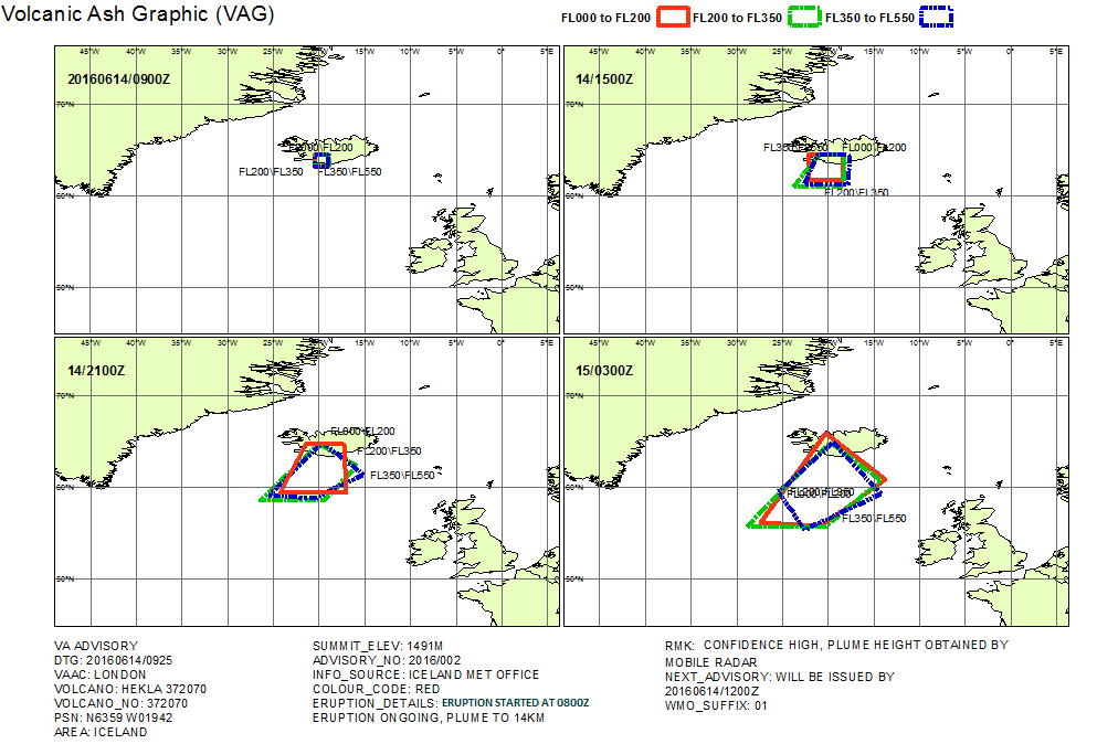
Example of volcanic ash advisory in graphical format from the London VAAC. Mercator projection.
Note: The example above is fictitious.
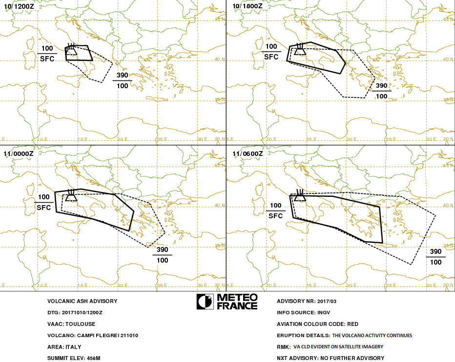
Example of volcanic ash advisory in graphical format from the Toulouse VAAC. Mercator projection.
Note: The example above is fictitious.
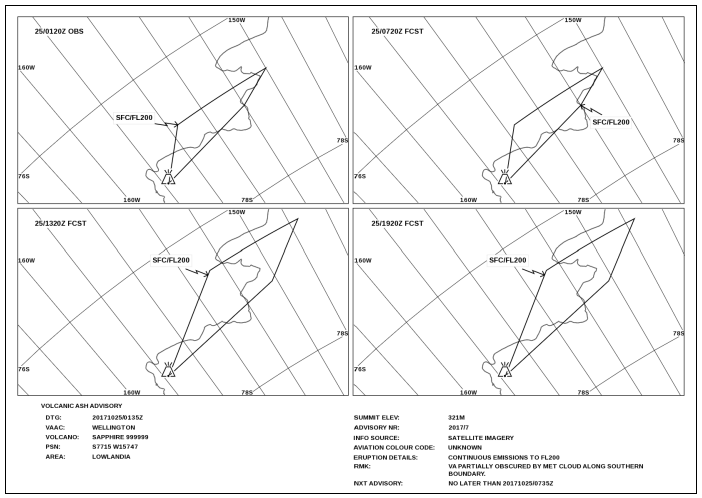
Example of volcanic ash advisory in graphical format from the Wellington VAAC. Polar stereographic projection.
Note: The example above is fictitious.
GM1 MET.TR.265 Volcanic ash advisory centre responsibilities
ED Decision 2022/004/R
EXAMPLES OF ADVISORY FOR VOLCANIC ASH
VA ADVISORY DTG: 20160614/0925Z VAAC: LONDON VOLCANO: HEKLA 372070 PSN: N6359 W01942 AREA: ICELAND SUMMIT ELEV: 1491M ADVISORY NR: 2016/002 INFO SOURCE: ICELAND MET OFFICE AVIATION COLOUR CODE: RED ERUPTION DETAILS: ERUPTION STARTED AT 0600Z ONGOING, PLUME TO 14KM OBS VA DTG: 14/0900Z OBS VA CLD: SFC/FL200 N6421 W02030 - N6421 W01900 - N6315 W01856 - N6303 W02025 - N6421 W02030 FL200/350 N6423 7W02021 - N6423 W01854 - N6309 W01856 - N6309 W02022 - N6423 W02021 FL350/550 N6422 W02023 - N6422 W01856 - N6304 W01854 - N6306 W02023 - N6422 W02023 FCST VA CLD +6HR: 14/1500Z SFC/FL200 N6423 W01822 - N6138 W01826 - N6135 W02205 - N6423 W02213 - N6423 W01822 FL200/350 N6425 W01814 - N6051 W01825 - N6050 W02348 - N6424 W02055 - N6425 W01814 FL350/550 N6419 W01737 - N6109 W01753 - N6116 W02234 - N6423 W02108 - N6419 W01737 FCST VA CLD +12HR: 14/2100Z SFC/FL200 N6449 W02121 - N6441 W01717 - N5921 W01659 - N5922 W02419 - N6449 W02121 FL200/350 N6441 W02002 - N6227 W01556 - N5831 W01927 - N5833 W02629 - N6441 W02002 FL350/550 N6448 W01941 - N6117 W01507 - N5846 W02024 - N5910 W02520 - N6448 W01941 FCST VA CLD +18HR: 15/0300Z SFC/FL200 N6554 W02018 - N6053 W01348 - N5542 W02046 - N5606 W02724 - N6554 W02018 FL200/350 N6446 W01949 - N6039 W01415 - N5535 W02019 - N5538 W02851 - N6446 W01949 FL350/550 N6500 W01928 - N5918 W01407 - N5516 W02235 - N5927 W02532 - N6500 W01928 RMK: T+0 CONFIDENCE HIGH, PLUME HEIGHT OBTAINED BY MOBILE RADAR NXT ADVISORY: WILL BE ISSUED BY 20160614/1200Z |
VA ADVISORY VA ADVISORY DTG: 20171010/1200Z VAAC: TOULOUSE VOLCANO: CAMPI FLEGREI 211010 PSN: N4049 E01408 AREA: ITALY SUMMIT ELEV: 458M ADVISORY NR: 2017/03 INFO SOURCE: INGV AVIATION COLOUR CODE: RED ERUPTION DETAILS: THE VOLCANO ACTIVITY CONTINUES OBS VA DTG: 10/0600Z OBS VA CLD: SFC/FL100 N4135 E01325 - N4155 E01410 - N4155 E01610 - N4000 E01655 - N4005 E01335 - N4135 E01325 FL100/390 N4130 E01335 - N4150 E01410 - N4115 E01645 - N3940 E01925 - N3715 E01800 - N3745 E01630 - N3910 E01500 - N4000 E01335 - N4130 E01335 MOV SE 20KT FCST VA CLD +6HR: 10/1800Z SFC/FL100 N4150 E01255 - N4220 E01535 - N4115 E01845 - N3940 E01955 - N3820 E01915 - N4000 E01235 - N4150 E01255 FL100/390 N4135 E01310 - N4120 E02050 - N3750 E02335 - N3520 E02215 - N3525 E01935 - N3840 E01640 - N3945 E01255 - N4135 E01310 FCST VA CLD +12HR: 11/0000Z SFC/FL100 N4150 E01210 - N4215 E01530 - N4130 E01935 - N3925 E02200 - N3700 E02125 - N3830 E01650 - N3920 E01220 - N4150 E01210 FL100/390 N4130 E01310 - N4140 E02020 - N4030 E02400 - N3645 E02555 - N3455 E02350 - N3810 E01820 - N3935 E01255 - N4130 E01310 FCST VA CLD +18HR: 11/0600Z SFC/FL100 N4125 E01255 - N4120 E01820 - N4000 E02405 - N3530 E02430 - N3540 E02220 - N3725 E01845 - N3840 E01320 - N4115 E01255 - N4125 E01255 FL100/390 N4135 E01300 - N4145 E02010 - N4115 E02650 - N3900 E03105 - N3250 E02805 - N3720 E01830 - N3845 E01340 - N4135 E01300 RMK: VA CLD EVIDENT ON SATELLITE IMAGERY NXT ADVISORY: NO FURTHER ADVISORY |
Chapter 5 — Technical requirements for tropical cyclone advisory centres (TCACs)
MET.TR.270 Tropical cyclone advisory centre responsibilities
Regulation (EU) 2021/1338
The advisory information on tropical cyclones shall be issued in accordance with the template shown in Appendix 7 for tropical cyclones when the maximum of the 10-minute mean surface wind speed is expected to reach or exceed 34 kt during the period covered by the advisory.
AMC1 MET.TR.270 Tropical cyclone advisory centre responsibilities
ED Decision 2022/004/R
TROPICAL CYCLONE ADVISORY — CODE FORM
Tropical cyclone advisory should be disseminated using:
(a)the IWXXM GML form as specified in point (a) of AMC1 MET.TR.115(a);
(b)abbreviated plain language as specified in point (c) of AMC1 MET.TR.115(a).
AMC2 MET.TR.270 Tropical cyclone advisory centre responsibilities
ED Decision 2022/004/R
TROPICAL CYCLONE ADVISORY — GRAPHICAL FORMAT
The tropical cyclone advisory information listed in Appendix 7 to Annex V (Part-MET) to Regulation (EU) 2017/373, when prepared in graphical format, should be as specified below and issued using the portable network graphics (PNG) format as specified in point (f) of
AMC1 MET.TR.115(a):
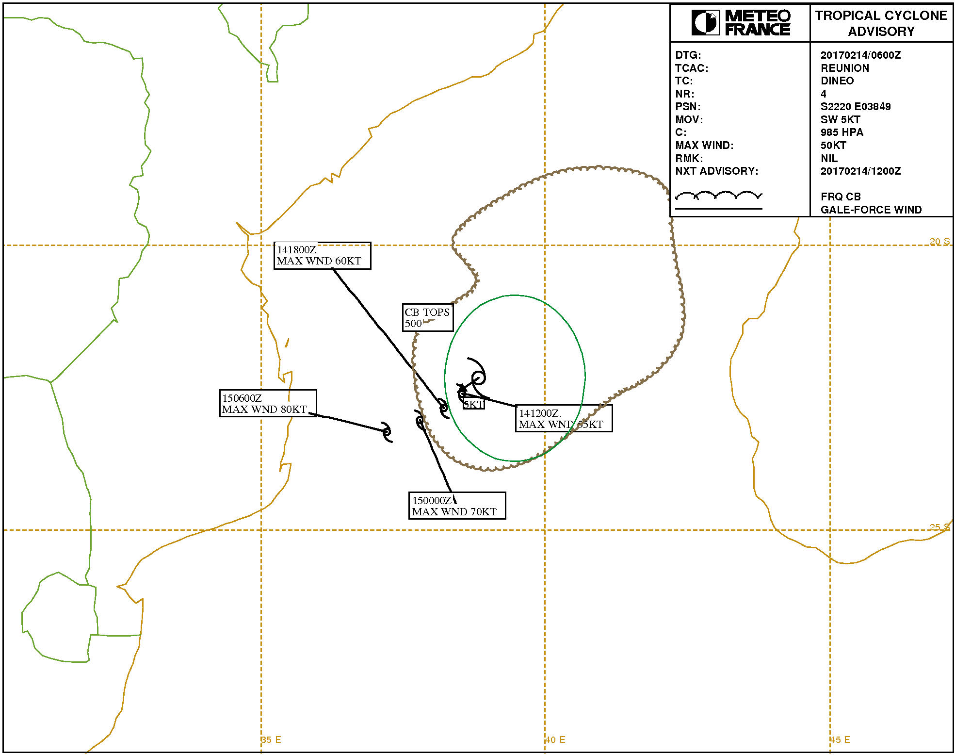
Example of tropical cyclone advisory in graphical format from the La Réunion TCAC.
Note: The example above is based on a real event.
GM1 MET.TR.270 Tropical cyclone advisory centre responsibilities
ED Decision 2022/004/R
ADVISORY FOR TROPICAL CYCLONES — EXAMPLE
TC ADVISORY DTG: 20170214/0600z TCAC: REUNION TC: DINEO ADVISORY NR: 2004/4 OBS PSN: 14/0600Z S2220 E03849 CB: WI 300NM OF TC CENTRE TOP FL500 MOV: SW 05KT INTST CHANGE: INTSF C:985HPA MAX WIND:50KT FCST PSN +06HR:14/1200Z S2236 E03831 FCST MAX WIND +06HR:55KT FCST PSN +12HR:14/1800Z S2251 E03812 FCST MAX WIND +12HR:60KT FCST PSN +18HR:15/0000Z S2304 E03748 FCST MAX WIND +18HR:70KT FCST PSN +24HR:15/0600Z S2316 E03712 FCST MAX WIND +24HR:80KT RMK:NIL NXT MSG:20170214/1200Z |
Chapter 6 — Technical requirements for world area forecast centres (WAFCs)
MET.TR.275 World area forecast centre responsibilities
Regulation (EU) 2021/1338
(a)WAFCs shall use processed meteorological data in the form of grid point values for the supply of gridded global forecasts and forecasts of significant weather phenomena.
(b)For global gridded forecasts, WAFCs shall:
(1)prepare forecasts of:
(i)upper wind;
(ii)upper-air temperature;
(iii)humidity;
(iv)direction, speed and flight level of maximum wind;
(v)flight level and temperature of tropopause;
(vi)areas of cumulonimbus clouds;
(vii)icing;
(viii)turbulence;
(ix)geopotential altitude of flight levels;
four times a day and be valid for fixed valid times at 6, 9, 12, 15, 18, 21, 24, 27, 30, 33 and 36 hours after the time (00.00, 06.00, 12.00 and 18.00 UTC) of the synoptic data on which the forecasts were based;
(2)issue forecasts referred to in point (1) and complete their dissemination as soon as technically feasible, but not later than 5 hours after standard time of observation;
(3)provide grid point forecasts in a regular grid comprising:
(i)wind data for flight levels 50 (850 hPa), 80 (750 hPa), 100 (700 hPa), 140 (600 hPa), 180 (500 hPa), 210 (450 hPa), 240 (400 hPa), 270 (350 hPa), 300 (300 hPa), 320 (275 hPa), 340 (250 hPa), 360 (225 hPa), 390 (200 hPa), 410 (175 hPa), 450 (150 hPa), 480 (125 hPa) and 530 (100 hPa) with a horizontal resolution of 1,25° of latitude and longitude;
(ii)temperature data for flight levels 50 (850 hPa), 80 (750 hPa), 100 (700 hPa), 140 (600 hPa), 180 (500 hPa), 210 (450 hPa), 240 (400 hPa), 270 (350 hPa), 300 (300 hPa), 320 (275 hPa), 340 (250 hPa), 360 (225 hPa), 390 (200 hPa), 410 (175 hPa), 450 (150 hPa), 480 (125 hPa) and 530 (100 hPa) with a horizontal resolution of 1,25° of latitude and longitude;
(iii)humidity data for flight levels 50 (850 hPa), 80 (750 hPa), 100 (700 hPa), 140 (600 hPa) and 180 (500 hPa) with a horizontal resolution of 1,25° of latitude and longitude;
(iv)geopotential altitude data for flight levels 50 (850 hPa), 80 (750 hPa), 100 (700 hPa), 140 (600 hPa), 180 (500 hPa), 210 (450 hPa), 240 (400 hPa), 270 (350 hPa), 300 (300 hPa), 320 (275 hPa), 340 (250 hPa), 360 (225 hPa), 390 (200 hPa), 410 (175 hPa), 450 (150 hPa) 480 (125 hPa) and 530 (100 hPa) with a horizontal resolution of 1,25° of latitude and longitude;
(v)direction, speed and flight level of maximum wind with a horizontal resolution of 1,25° of latitude and longitude;
(vi)flight level and temperature of tropopause with a horizontal resolution of 1,25° of latitude and longitude;
(vii)icing for layers centred at flight levels 60 (800 hPa), 100 (700 hPa), 140 (600 hPa), 180 (500 hPa), 240 (400 hPa) and 300 (300 hPa) with a horizontal resolution of 0,25° of latitude and longitude;
(viii)turbulence for layers centred at flight levels 100 (700 hPa), 140 (600 hPa), 180 (500 hPa), 240 (400 hPa), 270 (350 hPa), 300 (300 hPa), 340 (250 hPa), 390 (200 hPa) and 450 (150 hPa) with a horizontal resolution of 0,25° of latitude and longitude;
(ix)horizontal extent and flight levels of base and top of cumulonimbus clouds with a horizontal resolution of 0,25° of latitude and longitude.
(c)For global forecasts of en-route significant weather phenomena, WAFCs shall:
(1)prepare SIGWX forecasts four times a day and shall be valid for fixed valid times at 24 hours after the time (00.00, 06.00, 12.00 and 18.00 UTC) of the synoptic data on which the forecasts were based. The dissemination of each forecast shall be completed as soon as technically feasible, but not later than 7 hours after standard time of observation under normal operations and not later than 9 hours after standard time of observation during backup operations;
(2)issue SIGWX forecasts as high-level SIGWX forecasts for flight levels between 250 and 630;
(3)include in SIGWX forecasts the following items:
(i)tropical cyclone provided that the maximum of the 10-minute mean surface wind speed is expected to reach or exceed 34 kt;
(ii)severe squall lines;
(iii)moderate or severe turbulence (in cloud or clear air);
(iv)moderate or severe icing;
(v)widespread sandstorm/dust storm;
(vi)cumulonimbus clouds associated with thunderstorms and with points (i) to (v);
(vii)non-convective cloud areas associated with in-cloud moderate or severe turbulence and/or moderate or severe icing;
(viii)flight level of tropopause;
(ix)jet streams;
(x)information on the location of volcanic eruptions that are producing ash clouds of significance to aircraft operations, comprising: volcanic eruption symbol at the location of the volcano and, in a separate text box on the chart, the volcanic eruption symbol, the name of the volcano, if known, and the latitude/longitude of the eruption. In addition, the legend of SIGWX charts should indicate ‘CHECK SIGMET, ADVISORIES FOR TC AND VA, AND ASHTAM AND NOTAM FOR VA’;
(xi)information on the location of a release of radioactive materials into the atmosphere of significance to aircraft operations, comprising: the radioactive materials in the atmosphere symbol at the location of the release and, in a separate box on the chart, the radioactive materials in the atmosphere symbol, latitude/longitude of the site of the release and, if known, the name of the site of the radioactive source. In addition, the legend of SIGWX charts on which a release of radiation is indicated should contain ‘CHECK SIGMET AND NOTAM FOR RDOACT CLD’.
(4)The following criteria shall be applied for SIGWX forecasts:
(i)points (i) to (vi) of point (3) shall only be included if expected to occur between the lower and upper levels of the SIGWX forecast;
(ii)the abbreviation ‘CB’ shall only be included when it refers to the occurrence or expected occurrence of cumulonimbus clouds:
(A)affecting an area with a maximum spatial coverage of 50 % or more of the area concerned;
(B)along a line with little or no space between individual clouds; or
(C)embedded in cloud layers or concealed by haze;
(iii)the inclusion of ‘CB’ shall be understood to include all weather phenomena normally associated with cumulonimbus clouds, i.e. thunderstorm, moderate or severe icing, moderate or severe turbulence, and hail;
(iv)where a volcanic eruption or a release of radioactive materials into the atmosphere warrants the inclusion of the volcanic activity symbol or the radioactivity symbol in SIGWX forecasts, the symbols shall be included on SIGWX forecasts irrespective of the height to which the ash column or radioactive material is reported or expected to reach;
(v)in the case of coincident or the partial overlapping of points (i), (x) and (xi) of point (3), the highest priority shall be given to point (x), followed by points (xi) and (i). The point with the highest priority shall be placed at the location of the event, and an arrow shall be used to link the location of the other point(s) to its (their) associated symbol(s) or text box(es).
(d)Medium-level SIGWX forecasts for flight levels between 100 and 450 for limited geographical areas shall be issued.
AMC1 MET.TR.275(a) World area forecast centres (WAFCs) responsibilities
ED Decision 2017/001/R
GRIDDED GLOBAL FORECASTS
The telecommunications facilities used for the supply of world area forecast system products should:
(a)be the aeronautical fixed service or the public Internet;
(b)be continuous; and
(c)not have interruptions exceeding 10 minutes during any period of 6 hours.
AMC2 MET.TR.275(a) World area forecast centre responsibilities
ED Decision 2022/004/R
WORLD AREA FORECAST CENTRE GLOBAL GRIDDED FORECASTS — CODE FORM
World area forecast centre global gridded forecasts should be encoded using the GRIB code form as specified in point (d) of AMC1 MET.TR.115(a).
GM1 MET.TR.275(b)(3) World area forecast centre responsibilities
ED Decision 2022/004/R
GRID POINT FORECASTS
(a)Layers centred at a flight level referred to in MET.TR.275(b)(3)(vii) have a depth of 100 hPa.
(b)Layers centred at a flight level referred to in MET.TR.275(b)(3)(viii) have a depth of 100 hPa for flight levels below 240, then 50 hPa for flight levels 240 and above.
GM2 MET.TR.275(b)(3) World area forecast centre responsibilities
ED Decision 2022/004/R
GRID POINT FORECASTS
The turbulence referred to in MET.TR.275(b)(3)(viii) encompasses all types of turbulence, including clear-air turbulence and in-cloud turbulence.
GM3 MET.TR.275(b)(3) World area forecast centre responsibilities
ED Decision 2022/004/R
GRID POINT FORECASTS
The exact pressure levels (hPa) for MET.TR.275(b)(3) (i), (ii), (iii), (iv), (vii), and (viii) are provided in ICAO Doc 8896 ‘Manual of Aeronautical Meteorological Practice’.
AMC1 MET.TR.275(c) World area forecast centre responsibilities
ED Decision 2022/004/R
WORLD AREA FORECAST CENTRE (WAFC) GLOBAL FORECASTS OF SIGNIFICANT WEATHER — CODE FORM
World area forecast centre (WAFC) global forecasts of significant weather should be disseminated using:
(a)the IWXXM GML form as specified in point (a) of AMC1 MET.TR.115(a);
(b)the BUFR code form as specified in point (e) of AMC1 MET.TR.115(a).
AMC1 MET.TR.275(d) World area forecast centre responsibilities
ED Decision 2022/004/R
MEDIUM-LEVEL SIGWX FORECASTS
The medium-level SIGWX forecasts provided for flight levels between 100 and 450 for limited geographical areas should cover the areas as shown in Appendix 2.
APPENDICES TO ANNEX V
Appendix 1
Regulation (EU) 2021/1338
Template for METAR and SPECI Key: M=inclusion mandatory; C=inclusion conditional, dependent on meteorological conditions or method of observation; O=inclusion optional. Note 1: The ranges and resolutions for the numerical elements included in METAR and SPECI are provided in a separate table below this template. Note 2: The explanations for the abbreviations can be found in ICAO Document 8400 Procedures for Air Navigation Services — Abbreviations and Codes (PANS-ABC). Note 3: Row numbers in the ‘Ref.’ column are included only for clarity and ease of reference, and are not part of the METAR and SPECI. | ||||||||
Ref. | Element | Detailed content | Template(s) | |||||
1 | Identification of the type of report (M) | Type of report (M) | METAR, METAR COR, SPECI or SPECI COR | |||||
2 | Location indicator (M) | ICAO location indicator (M) | nnnn | |||||
3 | Time of the observation (M) | Day and actual time of the observation in UTC (M) | nnnnnnZ | |||||
4 | Identification of an automated or missing report (C) | Automated or missing report identifier (C) | AUTO or NIL | |||||
5 | END OF METAR IF THE REPORT IS MISSING. | |||||||
6 | Surface wind (M) | Wind direction (M) | nnn or /// (41) | VRB | ||||
Wind speed (M) | [P]nn[n] or // (42) | |||||||
Significant speed variations (C) | G[P]nn[n] | |||||||
Units of measurement (M) | KT | |||||||
Significant directional variations (C) | nnnVnnn | — | ||||||
7 | Visibility (M) | Prevailing or minimum visibility (M) | nnnn or //// (43) | C A V O K | ||||
Minimum visibility and direction of the minimum visibility (C) | nnnn[N] or nnnn[NE] or nnnn[E] or nnnn[SE] or nnnn[S] or nnnn[SW] or nnnn[W] or nnnn[NW] | |||||||
8 | Runway visual range (C) (44) | Name of the element (M) | R | |||||
Runway (M) | nn[L]/or nn[C]/or nn[R]/ | |||||||
Runway visual range (M) | [P or M]nnnn or //// (451) | |||||||
Runway visual range past tendency (C) | U, D or N | |||||||
9 | Present weather (C) | Intensity or proximity of present weather (C) | – or + | — | VC | |||
Characteristics and type of present weather (M) | DZ or RA or SN or SG or PL or DS or SS or FZDZ or FZRA or FZUP (46) or FC (47) or SHGR or SHGS or SHRA or SHSN or SHUP (48) or TSGR or TSGS or TSRA or TSSN or TSUP (49) or UP (50) | FG or BR or SA or DU or HZ or FU or VA or SQ or PO or TS or BCFG or BLDU or BLSA or BLSN or DRDU or DRSA or DRSN or FZFG or MIFG or PRFG or // (51) | FG or PO or FC or DS or SS or TS or SH or BLSN or BLSA or BLDU or VA | |||||
10 | Cloud (M) | Cloud amount and height of cloud base or vertical visibility (M) | FEWnnn or SCTnnn or BKNnnn or OVCnnn or FEW/// (52) or SCT/// (53) or BKN/// (54) or OVC/// (55) or ///nnn (56) or ////// (57) | VVnnn or VV/// (58) | NSC or NCD (59) | |||
Cloud type (C) | CB or TCU or /// (60),(61) | — | ||||||
11 | Air and dew-point temperature (M) | Air and dew-point temperature (M) | [M]nn/[M]nn or ///[M]nn (62) or [M]nn/// (63) or ///// (64) | |||||
12 | Pressure values (M) | Name of the element (M) | Q | |||||
QNH (M) | nnnn or //// (65) | |||||||
13 | Supplementary information (C) | Recent weather (C) | RERASN or REFZDZ or REFZRA or REDZ or RE[SH]RA or RE[SH]SN or RESG or RESHGR or RESHGS or REBLSN or RESS or REDS or RETSRA or RETSSN or RETSGR or RETSGS or RETS or REFC or REVA or REPL or REUP (66) or REFZUP (67) or RETSUP (68) or RESHUP (69) or RE// (70) | |||||
Wind shear (C) | WS Rnn[L] or WS Rnn[C] or WS Rnn[R] or WS ALL RWY | |||||||
Sea-surface temperature and state of the sea or significant wave height (C) | W[M]nn/Sn or W///Sn (71) or W[M]nn/S/ (72) or W[M]nn/Hn[n][n] or W///Hn[n][n] (73) or W[M]nn/H/// (74) | |||||||
14 | Trend forecast (O) | Change indicator (M) | NOSIG | BECMG or TEMPO | ||||
Period of change (C) | FMnnnn and/or TLnnnn or ATnnnn | |||||||
Wind (C) | nnn[P]nn[G[P]nn]KT | |||||||
Prevailing visibility (C) | nnnn | C A V O K | ||||||
Weather phenomenon: intensity (C) | – or + | — | N S W | |||||
Weather phenomenon: characteristics and type (C) | DZ or RA or SN or SG or PL or DS or SS or FZDZ or FZRA or SHGR or SHGS or SHRA or SHSN or TSGR or TSGS or TSRA or TSSN | FG or BR or SA or DU or HZ or FU or VA or SQ or PO or FC or TS or BCFG or BLDU or BLSA or BLSN or DRDU or DRSA or DRSN or FZFG or MIFG or PRFG | ||||||
Cloud amount and height of cloud base or vertical visibility (C) | FEWnnn or SCTnnn or BKNnnn or OVCnnn | VVnnn or VV/// | N S C | |||||
Cloud type (C) | CB or TCU | — | ||||||
Ranges and resolutions for the numerical elements included in METAR and SPECI | |||||
Ref. | Elements | Range | Resolution | ||
1 | Runway: | (no units) | 01–36 | 1 | |
2 | Wind direction: | °true | 000–360 | 10 | |
3 | Wind speed: | KT | 00–99 P99 | 1 N/A (100 or greater) | |
4 | Visibility: | M | 0000–0750 | 50 | |
M | 0800–4 900 | 100 | |||
M | 5 000–9 000 | 1 000 | |||
M | 10 000 or greater | 0 (fixed value: 9 999) | |||
5 | Runway visual range: | M | 0000–0375 | 25 | |
M | 0400–0750 | 50 | |||
M | 0800–2 000 | 100 | |||
6 | Vertical visibility: | 100’s FT | 000–020 | 1 | |
7 | Clouds: height of cloud base: | 100’s FT | 000–099 100-200 | 1 10 | |
8 | Air temperature: Dew-point temperature: | °C | –80 – +60 | 1 | |
9 | QNH: | hPa | 0850–1 100 | 1 | |
10 | Sea-surface temperature: | °C | –10 – +40 | 1 | |
11 | State of the sea: | (no units) | 0–9 | 1 | |
12 | Significant wave height: | M | 0–999 | 0,1 | |