Update on 22 October 2025 to take into account an update to the EASA SIB with changes to the recommendations to ANSPs and some small ones to the recommendations for operators.
Update on 30 August 2023 with a poster and safety information leaflet from DGAC France - access the original leaflet here.
Updated on 18 August 2023 with the latest ICAO EUR OPS Bulletin 2023_001 on risks related to altimeter setting errors during APV Baro-VNAV and non-precision approach operations <Download at the bottom of the page>.
Issue awareness and continuous improvement are key to safe operations. Following recent serious incidents on the effects of incorrect barometric altimeter settings, particularly, when operating below the transition altitude, back in 2023 EASA issued SIB 2023-03.
The SIB was developed in consultation with several subject matter experts. This article provides the chance to explain the wider context of the SIB and cover some of the wider topics associated with this safety risk.
Understanding more about the risk
In aviation, vertical navigation based on barometric altimetry and vertical references on navigation charts traditionally rely on the use of local barometric pressure, i.e., QNH (or QFE); hence, operating with an incorrect altimeter setting could lead to flying closer to terrain or obstacles than expected. It may also lead to a loss of separation with other aircraft. In the worst-case scenario, having an incorrect barometric altimeter setting could lead to a loss of adequate terrain clearance and in the worse case, a CFIT.
An incorrect barometric altimeter setting is a known vulnerability that, in some cases, has proved to degrade pilots’ situational awareness. An incorrect QNH/QFE below the transition level/altitude could result in minimum safe altitudes being infringed, including minimum vectoring altitudes, published decision altitudes, step-down altitudes, etc.
In particular, an incorrect barometric altimeter setting could affect the safety margins that protect a variety of approach procedures that rely on barometric altimetry for vertical navigation (e.g., RNP APCH down to LNAV/VNAV minima, RNP AR APCH) or that are flown using the CDFA technique that rely on a BARO-VNAV equipment onboard to compute the vertical profile and to provide vertical guidance along the descent (e.g., NDB, VOR, LOC, RNP APCH down to LNAV).
It is particularly worth highlighting that when using barometric altimetry for vertical navigation, altitude/distance cross checks in the standard operating procedures do not detect an incorrect barometric altimetry setting.
On the other hand, vertical guidance provided by ILS, SBAS or GBAS is not vulnerable to an incorrect barometric setting and, contrary to vertical guidance based on barometric altimetry (e.g., supported BARO-VNAV equipment), errors in barometric altimeter settings can be detected through altitude (glide path) checks.
In particular, when vertical navigation relies on barometric altimetry, a precise barometric altimeter setting is paramount; otherwise, an incorrect vertical profile will be flown, i.e., either lower or higher than desired, depending on whether the incorrect QNH (or QFE) is, respectively, greater or lower than the actual QNH (or QFE).
The diagram below helps to highlight what the situation might look like from a practical perspective.
<photo credit Airbus>
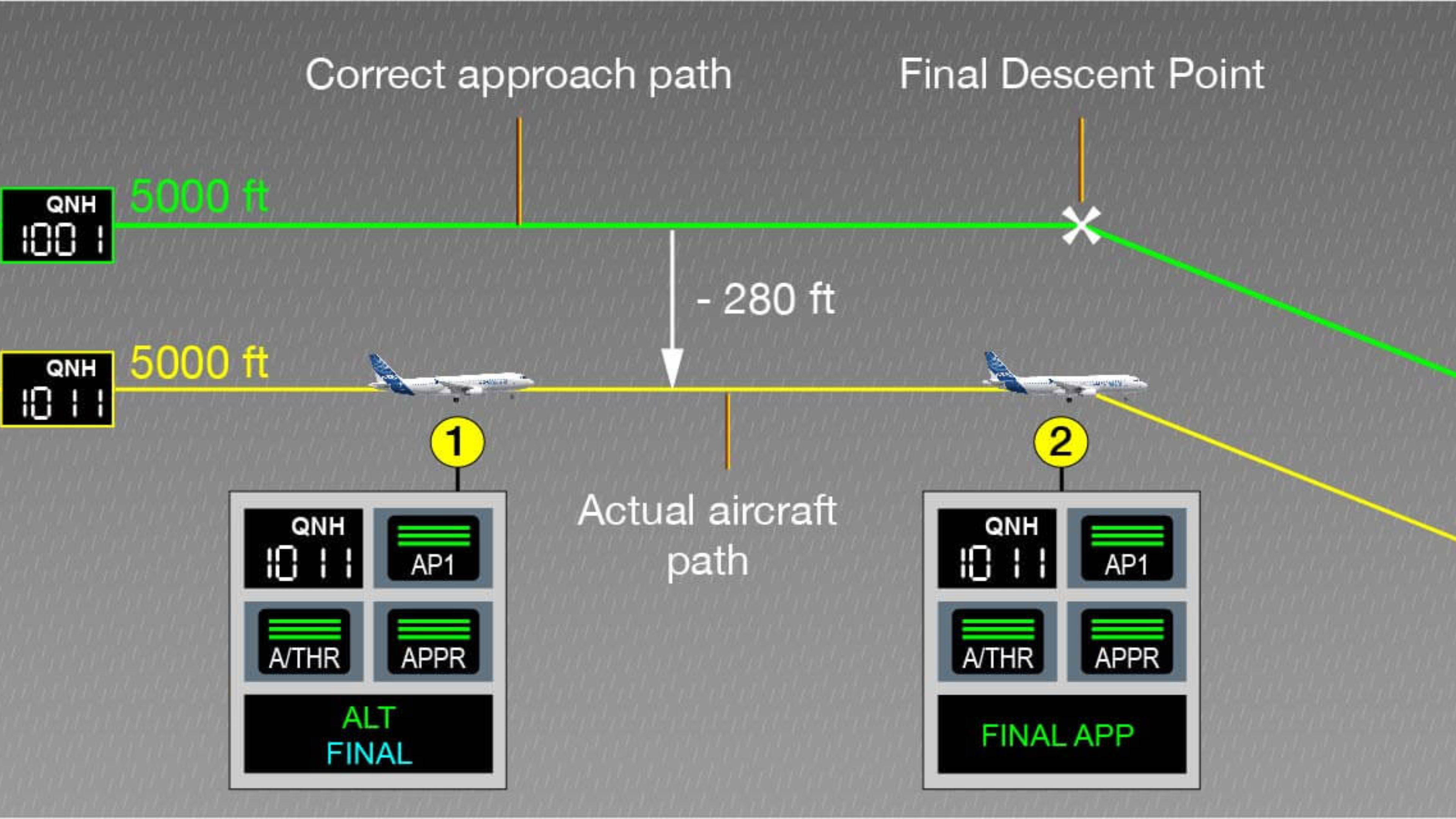
On the above figure, a 10 hPa error in altimeter setting translates into 280 ft altitude error. This means that the altitude displayed may differ significantly from the actual altitude.
It is worth noting that the effects of an incorrect barometric altimeter setting are similar to those associated with very low or high temperatures, whose mitigation requires error corrections on barometric altimeters readings (temperature corrections).
The possible errors that could be introduced
Setting the correct barometric values in the cockpit requires a number of different people to do the right things. This is where the possibility for error comes in, these include:
- The provision of the local barometric pressure by the meteorological service provider.
- The broadcasting of the local QNH (or QFE) through ATIS (where available) or the radio transmission of the local QNH (or QFE) by the ATS unit.
- Finally, the altimeter setting by the flight crew.
Prevention and detection mechanisms
There are a number of barriers in the system that help to prevent a barometric setting error, identify one quickly if it happens and then to mitigate the risk of an accident the longer such a situation continues.
Effective communication
Following voice communication procedures is key to preventing or detecting an incorrect barometric altimeter setting. In particular, it is important to do the following:
- Standard Phraseology. Apply standard phraseology at all times so that everyone on frequency knows what is being said and to help errors to be identified.
- Readback/ Hearback: Ensure effective readback and hearback of transmissions that include the QNH (or QFE) for operations below the transition altitude/level.
- Active Listening: Actively listen to voice transmissions to help detect an incorrect barometric altimeter setting, e.g., controllers are expected to listen to the readbacks to ascertain that a clearance that includes the QNH (or QFE) has been correctly acknowledged by the flight crew and correct any discrepancies revealed by the readback, whereas pilots can detect inconsistent QNH (or QFE) being issued to other aircraft on the frequency.
- Use of English: Use English as the common operational language where there is international air traffic to help improve everyone’s situational awareness.
Effective use of ATM systems
Another barrier is the effective use of systems that help ATS units to monitor the progress of approach operations, e.g., the minimum safe altitude warning (MSAW) system or an approach path monitoring (APM) system, which are helpful against the risk of CFIT. When using these systems, there should be local ATS procedures and ATCO training to ensure that controllers understand the functionality in use and can react in different circumstances, including the issuance of clear messages to pilots.
As safety nets are commonly adapted to the ATS unit, this needs to be considered when constructing the procedures and training. Recent incidents have shown that, when safety nets alerts are triggered a prompt and accurate reaction from the controller is essential to enable pilots to take timely corrective action.
Pilot Monitoring of ATS Messages
Pilots must remain attentive to any ATS related messages and react promptly, including the execution of a go-around, when necessary. For example, a low altitude warning transmitted by and ATS unit includes, as part of the standard phraseology, the QNH, together with an instruction to check altitude, which can definitely help to detect an incorrect QNH setting: Low altitude warning ((aircraft call sign) LOW ALTITUDE WARNING, CHECK YOUR ALTITUDE IMMEDIATELY, QNH IS (number)[(units)]. [THE MINIMUM FLIGHT ALTITUDE IS (altitude)])
Use of Approach Lights
Should a barometric pressure error occur, if the pilots have external references they are more likely to identify the situation and take the right action. This is particularly a challenge in poor visibility. This means that the use of aeronautical ground lights can be particularly important to help manage this risk.
The rules in ATS.TR.150 say that all lights should be operated at night and close to sunset, or sunrise or “at any other time when their use, based on meteorological conditions, is considered desirable for the safety of air traffic”. It could help if runways that are in use for landing operations had their runway and approach lights kept on in all meteorological conditions in order to help pilots acquire visual references during the approach.
It is worth reminding that approach lights are meant to be on whenever the runway lights are on.
The recommended actions from the EASA SIB
Since the publication of the original issue of this SIB, additional incidents have been reported in which incorrect altimeter setting has been identified as a contributory or causal factor. Consequently, this SIB is revised to further clarify the recommendations to ANSPs and aircraft operators.
In addition to the barriers in place, to prevent the risk of incorrect barometric setting and mitigate its potential consequences, the following practices are recommended:
To Aircraft operators:
- Develop procedures to support pilots in checking the consistency of the QNH (or QFE) with previous settings and other available sources (e.g. ATIS).
- Assess the effectiveness of those already implemented procedures, and assess new procedures, e.g. pre-select altimeters based on latest information (e.g. ATIS), during the approach briefing. When this is not feasible, consider alternative systems to obtain/record QNH information during the approach briefing phase.
- Ensure that the latest available software version and the latest terrain and obstacle database are loaded in the TAWS.
- Investigate methods to identify incorrect altimeter setting with the FDM Programme.
To Air Traffic Service Providers:
- Ensure that a directed transmission containing QNH has been provided to each arriving aircraft at least once, and a correct readback has been received. In this regard, assess, and document, whether providing aircraft with a further QNH when cleared for approach, or at first contact with the tower, would be an appropriate mitigation to the referenced risk.
- Implement tools, where available within the existing technology and systems, to utilise the downlinked barometric pressure settings from Mode S EHS equipped aircraft to enable timely identification of aircraft operating with incorrect altimeter setting.
Monitoring this safety issue using FDM
Through EASA’s work in the European Operator’s FDM (EOFDM) forum, the group have developed 6 possible methods to help monitoring incorrect altimeter settings using your FDM programme.
- Absence of standard to barometric transition at the transition altitude (according to operator's SOPs): Altimeter barometric correction, pressure altitude, latitude, longitude and gear-compressed parameters have to be recorded. Requires the information of transition altitude for each airport.
- Altimeter barometric correction with different values on each side of the cockpit during the final approach: Altimeter barometric correction parameter on both sides, pressure altitude and gear-compressed parameters have to be recorded.
- Compare the published runway elevation with the corrected pressure altitude parameter after landing or before take-off: Corrected pressure altitude parameter, or alternatively the standard pressure altitude and the altimeter barometric correction parameter, latitude, longitude parameters and runway identification through the FDM software, either by accessing a runway position database, or by embedding the positions of all operated runways.
- Standard pressure altitude measured when the aircraft is on the runway and compared with the published runway elevation, to produce an estimation of QNH: This QNH estimation is compared with the altimeter barometric correction parameter. Standard pressure altitude, Altimeter barometric correction, Latitude, longitude parameters and runway identification through the FDM software, either by accessing a runway position database, or by embedding the positions of all operated runways. QNH-1013.25 hPa = expected baro correction, to be compared with altimeter barometric correction parameter.
- Comparison between altimeter barometric correction parameter and the QNH determined from the METARs at the time of the touch-down or lift-off: Altimeter barometric correction, latitude, longitude and gear-compressed parameters have to be recorded. QNH value is determined from external source (METAR from a weather data source). QNH-1013.25 hPa= expected baro correction, to be compared with altimeter barometric correction parameter.
- Analyse a sequence of take-offs or landings close in time, in the same day for a specific runway. Look for values of altimeter barometric correction parameter or corrected pressure altitude that are outliers: Corrected pressure altitude parameter or altimeter barometric correction parameter, latitude, longitude and gear-compressed parameters have to be recorded.
Some other considerations – Reporting is very important
While the SIB specifically covers operational aspects related to incorrect barometric pressure settings, there are some other areas that deserve consideration, in particular:
- Keep Reporting: To help your organisation and also the wider aviation system have the best picture of safety risks, it’s important to keep reporting occurrences and hazards, when they are identified. There is an article on that as well earlier in the magazine.
- Investigate and decide on any necessary mitigations: safety management systems include procedures to systematically investigate safety occurrences. This permits the continuous improvement of safety and the introduction of modifications to systems, procedures and personnel’s training to prevent hazards or mitigate their effects, if necessary. In order cases, the dissemination of lessons learnt from the investigation plays a paramount role to ensure that operational staff are aware.
Amazing subject and article. As a mitigation, we are simulating similar scenarios on SIM lessons in order to illustrate the causes and corrections, preferably on the LOFT lessons.
Excellent article. I will add this problem to our educational program for ATC and pilots students in Aviation Meteorology subject. I will suggest to my colegues in the ATC/Pilots Simulation Center to add the procedure of the QNH check.
Well, the provision of barometric pressure by the local meteorological service to ATC is automated, so the human mistake is eliminated. The problem can occur in case of a bad setting of the altitude of the pressure sensor (or technical failure). We've had this problem in the past at the airport. The problem was solved after high-precision measurement of the position and altitude of the new meteorological garden by the National Geographic Institute experts.
I have a question:
Is there a significant error in the altimeter setting that can result in the incident?
Please log in or sign up to comment.