PDF Download of the article available at the bottom of the page.
Extra-tropical and Tropical–like cyclones (Medicanes) in the Mediterranean
This summer has seen some weather-related challenges in Southern Europe involving a phenomena called ‘Medicanes’. If you operate in this part of the world, this article will help you learn more about them and the risks they bring to aviation.
Understanding Medicanes
There are a range of weather-induced hazards in the Mediterranean that involve short-lived depressions (Mediterranean lows or Mediterranean depressions). The most intense of these are called Mediterranean cyclones or ‘Medicanes’. Medicanes are tropical – like cyclones that occur over the Mediterranean Sea; although their structure and behaviour resemble the features of a hurricane, Medicanes are weaker in intensity, affect less area, have shorter lifetime and they are triggered by the strong temperature gradient of a cold pool in the higher atmosphere rather than the instability created by high sea surface temperatures.
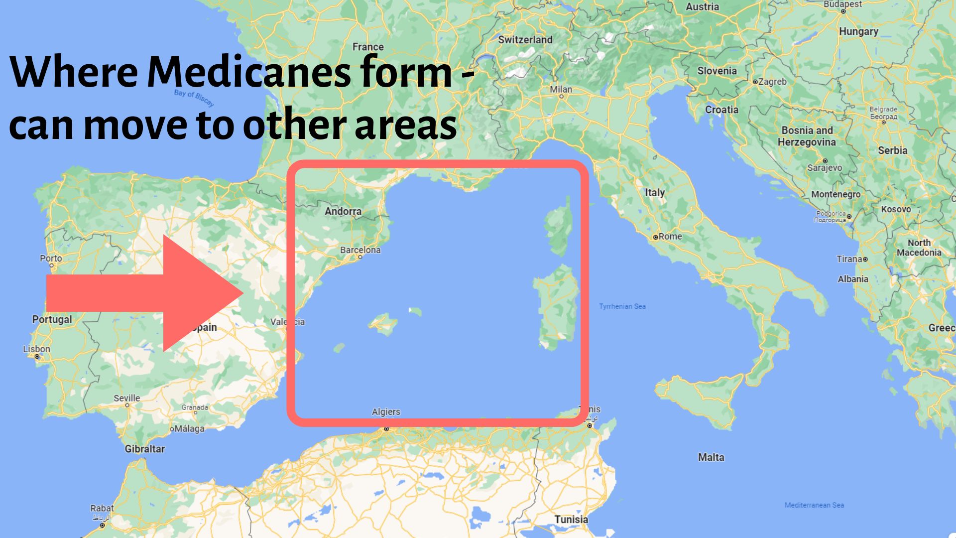
Most of the Medicanes on record have formed in the area bounded to the west by the coasts of Spain, to the north by the coast of France, to the east by the island of Corsica and to the south by the shores of Algeria. A secondary region of Medicane formation is the area between the gulf of Sidra up to Ionian Sea.
How is a Medicane characterized as a Medicane?
Cyclogenesis happens very often in the Mediterranean. On rare occasions, the development of these depressions is so rapid that they are characterized as “Meteorological Bombs”. In these occasions, the pressure in the centre of the cyclone drops by 24hpa in 24 hours or at a rate of 1hpa per hour. Obviously, Medicanes are almost always meteorological bombs. But most Meteorological bombs do not develop Medicane characteristics. Systems that obtain strength significant enough to be called Medicanes appear on average 1-2 times per year.
There is not yet a universally recognised scientific definition of what we call a “Medicane”. Some qualitative criteria to identify Medicanes include a continuous cloud cover and symmetric shape around a clearly visible cyclone eye, and sustained wind of 100km/hour or more.
Physical Characteristics of Medicanes
In general, most Medicanes have radius of 70 to 200 km, retain their tropical characteristics for up to 3 days and travel between 1,000 km and 3,000 km. Medicanes often dissipate into barometric lows of less dimension and weaker intensity and continue their trajectory until their rotational characteristics are completely lost, most often after they lose contact with the sea surface that provides them with moisture and energy.
A small proportion of Medicanes achieve sustained winds as strong as a Category 1 hurricane[1] and rarely, even more.
Climatology of Medicanes
Where do they occur?
- Western and central Mediterranean, and to a lesser extent the Levantine;
- More frequent in northern and central part of the Mediterranean basin in winter; and
- More frequent over North Africa in summer.
When are they likely to occur?
- Can occur year-round;
- Activity historically peaks between September and January ;
- June and July are the months with the lowest numbers of appearance.
Medicanes forecast
Forecasting time window
The triggering of these intense weather phenomena can be forecasted up to a week before. A significant uncertainty in the forecast lies within the intensity and the trajectory of the system which can be attributed to the small number of actual weather observations over the areas of formation.
Severe weather forecasts
Since Mediterranean is a closed sea that consists of many countries, each of them forecasts for its own area. Within the Network of European Meteorological Services (EUMETNET), there are alliances that forecast all severe weather events and issue a common naming for such events. This name is kept for all the areas that the severe weather event will affect, and it is communicated uniformly to public.
The warnings for each weather event and the areas affected are provided in the METEOALARM website. METEOALARM provides relevant information necessary to prepare for severe weather event, expected to occur somewhere over Europe. It alerts users to the possible occurrence of severe weather, such as heavy rain with risk of flooding, severe thunderstorms, gale-force winds, heat waves, etc. METEOALARM is developed for EUMETNET and the information it contains is provided by national weather services.
Europe | Meteoalarm – Alerting Europe for Extreme Weather
What can you do as an operator, airport or ANSP?
Knowing about Medicanes is a good start but if you are an operator, airport or ANSP you are probably wondering what you can do to mitigate the risk. There are two key challenges:
- The potential disruption to your operations in the Mediterranean when Medicanes occur, especially if it is for a prolonged time.
- The presence of specific hazards in your operational environment.
In terms of actions, you could do the following:
- Raise awareness and knowledge of Medicanes amongst your personnel e.g. airport support staff, controllers (for ATC), dispatchers, flight planners, flight crews, etc.
- Sharing this article might be a good starting point.
- Communicate the time of the year in which Medicanes usually occur: From September to January.
- Include the subject Medicanes into your safety training/briefings. Use case studies to show the impact Medicanes might have on operations.
- Perform a safety risk assessment in order to mitigate the risk coming from Medicanes. Hazards include but are not limited to: Strong winds, flash flooding (including airport infrastructure), wet/contaminated runways, heavy rain, severe turbulence, risk of diversions, altered route planning, fuel planning, disruptions in schedules, risk of foreign objects on the runway, lateral wind exceeding the aircraft crosswind limitations for landing. There is also the chance of strong tailwind at planned arrival airport that might require unexpected diversions given that tailwinds combined with a wet runway could seriously increase the risk of runway excursion.
- Adapt your SMS data collection (e.g. reporting descriptors) to include Medicanes.
- Share your experience in order to develop further mitigation actions for the future.
Future trends regarding Medicanes
In the Mediterranean Sea (especially the Eastern part) the rate of warming supersedes the global average. The change of many environmental parameters due to global warming is expected to change the frequency of appearances of Medicanes, their time and spatial magnitude and their impact, especially over coastlines.
Research work predict an increasing trend of appearances of strongest Medicanes in the short term and fewer appearance of weaker Medicanes (refer to IPCC Assessment Report No 6, Chapter 12).. Medicanes are likely to become more vigorous in autumn relative to spring and winter and to achieve more often hurricane intensity. Their tracks are likely to shift south and east in the Mediterranean, with more common occurrences in the Ionian Sea, a trend that has already been observed in the recent years.
[1] According to Saffir-Simpson hurricane wind scale category 1 means sustained winds with speed of 64 to 82 kt (119-153 km/h) and the following types of damage. ‘Very dangerous winds will produce some damage: Well-constructed frame homes could have damage to roof, shingles, vinyl siding and gutters. Large branches of trees will snap and shallowly rooted trees may be toppled. Extensive damage to power lines and poles likely will result in power outages that could last a few to several days.’
Thank you very much John for this article. Indeed, Medicanes should be a part of the crew weather briefing during the summer seasons. in the middle east and Asia, there is a special briefing to the pilots during the monsoon seasons. A special training is held by the airlines to qualify their pilots for the Monsoon period. Since the last 3 years I noticed the changes of the weather in the Mediterranean Sea and your article is more than welcome.
Please log in or sign up to comment.