Executive summary
Global Navigation Satellite Systems (GNSS) are now fundamental to modern rotorcraft operations. They enable instrument flight procedures that give helicopters safe, predictable access to airports, heliports, hospitals, offshore platforms, and remote or infrastructure‑limited locations – often the very places where public service, medical, and rescue missions matter most. As GNSS interference grows across parts of Europe and beyond, the European rotorcraft community faces a clear safety priority: build operational resilience, ensure robust contingency planning, and elevate pilot awareness and specific training on this area so mission continuity and safety margins can be maintained even when satellite navigation is degraded or provides erroneous data.
Low-Level IFR Routes (LLR), Point-in-Space (PinS) procedures, and Required Navigation Performance Approach (APCH) approach operations to Localiser Performance with Vertical Guidance (LPV), Lateral Navigation/Vertical Navigation (LNAV/VNAV), and Localiser Performance/Lateral Navigation (LP/LNAV) minima are entirely dependent on GNSS integrity. These are framed within ICAO’s performance‑based navigation concept, where Area Navigation (RNAV) provides area navigation capability and Required navigation Performance (RNP) adds onboard performance monitoring and alerting capability assured by the Flight Management System-Required Navigation Performance (FMS-RNP) system. IFR‑capable rotorcraft certificated in CS‑27 and CS‑29 rely extensively on these capabilities and are among the principal beneficiaries of satellite‑enabled procedures. At the same time interference, both jamming and spoofing, has increased in frequency and complexity, with data showing a steep rise in GNSS signal integrity loss events since 2021 and notable regional hotspots. The practical effects for helicopters are most acute when GNSS interference affects PinS approach, PinS departure and Low-Level Route (LLR) operations into uncontrolled airspace, and operations at remote sites in Instrument Meteorological Conditions (IMC). In these conditions, crew workload is critically elevated at the most demanding phase of flight, often in terrain‑constrained environments where the safety margin is already narrow. European and international initiatives now focus on improved reporting, enhanced prevention and resilience, better airspace and infrastructure use, and coordinated preparedness. For rotorcraft, the overarching shift is from reliance on GNSS to resilience in the face of its disruption.
The Annex provides a Rotorcraft Pilot Quick Reference Handbook. It addresses recognition cues (jamming, spoofing, degradation), immediate pilot actions, crew resource management, and after‑landing/post‑event steps. It also delivers a core safety message encouraging pilots to treat every integrity warning as real. Pilots are invited to assess the situation, adapt speed and flight path as necessary, transition to backups or visual navigation, and report promptly.
Note: While this article was being finalised, EASA and EUROCONTROL released, on 26 March 2026, a joint Action Plan to strengthen the safety and resilience of European aviation operations in response to the growing challenge posed by GNSS interference. This Action Plan is not used in this article; readers are therefore encouraged to consult it here.
1. Why GNSS matters for rotorcraft operations
GNSS satellite‑based navigation transformed what helicopters can safely and predictably achieve under IFR. PinS procedures allow instrument access to locations that lack conventional ground‑based aids. LLRs connect critical nodes, such as hospitals, police bases, SAR staging points, at altitudes compatible with rotorcraft performance and mission profiles. RNP APCH procedures enable stabilised, repeatable instrument approaches with scalable minima, including LPV where SBAS is available. Together, these capabilities allow helicopters to operate safely in adverse weather and at night in areas that would otherwise be inaccessible or too demanding and risky to operate in.
This entire set of capabilities sits within the ICAO performance‑based navigation framework. RNAV describes area navigation based on a mix of sensors, including GNSS, while RNP adds onboard performance monitoring and alerting; integrity features that are indispensable during Required Navigation Performance 0.3 for Low‑Level Routes (RNP0.3), RNP terminal procedures and RNP APCH approaches. The operational benefit is particularly high for CS‑27 and CS‑29 rotorcraft used for emergency medical services, search and rescue, public service, and offshore logistics. In these missions, GNSS is not merely a convenience; it often provides the only viable instrument procedure to a destination that lacks conventional aids such as VOR, DME, or ILS. The upshot is a sector‑wide dependence on satellite signals for reliable IFR access where society most needs rotorcraft capability.
GNSS also supports VFR operations by providing pilots with continuous, reliable positional awareness, which enhances navigation accuracy, improves route planning, and contributes to safer decision‑making in all phases of flight.
2. GNSS interference in aeroplane operations
Within the European Plan for Aviation Safety, the safety issue “Impact of GNSS interference on civil aviation operations” (Safety Issue-0034) carries one of the highest Safety Issue Priority Index scores for Commercial Air Transport – Aeroplanes. This reflects aviation’s broad dependence on satellite‑based services and exposure to vulnerabilities that may compromise flight safety when those services are degraded, denied, or manipulated.
This safety issue concerns aviation’s strong dependence on satellite‑based services and the vulnerabilities that may compromise flight safety.
Jamming and spoofing are the two principal mechanisms of concern. Jamming is intentional radio‑frequency interference that prevents receivers from locking onto satellite signals, while spoofing consists of broadcasting counterfeit signals that mislead receivers with incorrect position, navigation, and timing.
Either can corrupt or degrade navigation, surveillance, communication, and timing services. The impacts reach beyond the aircraft to the wider ATM – Air Traffic Management/Air Navigation Services (ATM/ANS) system, affecting procedures, training, and the very structure of published routes. When GNSS equipment fails or becomes unreliable in flight, crews must revert to alternative navigation means or ground‑based aids, with the greatest challenges arising during critical flight phases where workload is already high.
There is an additional human‑factors risk: the normalisation of deviance. If crews are frequently exposed to spurious alerts or transient degradations, they may become desensitised to warnings, delaying or blunting the correct response. The situation worsens when multiple issues occur together, interference coinciding with weather or system failures, raising workload for both pilots and controllers and eroding the capacity to diagnose the event. The ultimate safety implications are serious. Loss, corruption, or falsification of position, navigation, or timing information can culminate in airspace infringement, terrain collision, or mid‑air conflict if not recognised and managed promptly and correctly.
Operational data show a rapid increase in interference. GNSS signal‑loss events have risen sharply since 2021, with widespread occurrences of jamming and spoofing, especially in some parts of Eastern Europe and the Middle East, though it is not confined to those regions. The trend is not only a matter of numbers, but the event complexity has also increased as well. From a risk‑management perspective, this necessitates both prevention and resilience. Preventing exposure where feasible and ensuring operations can continue safely when exposure occurs. Regulators have provided guidance, such as safety information on GNSS outages and alterations leading to CNS degradation, emphasising robust reporting, structured crew responses, and the use of alternate navigation strategies when GNSS integrity cannot be assured.
The safety issue is therefore not abstract. It is systemic, it is growing, and it requires a cross‑cutting response that addresses technology, procedures, training, and airspace management. Although these insights were developed primarily with fixed‑wing CAT operations in mind, their logic applies critically to rotorcraft, where dependencies and constraints are often greater and margins can be thinner.
EASA issued the third revision of the Safety Information Bulletin (SIB) 2022-02R3 on July 5, 2024, addressing the increasing issues related to GNSS outages and alterations. This bulletin, targeted at competent authorities, providers of air traffic management, Air Navigation Service Providers (ANSPs), air operators, and aircraft and equipment manufacturers, highlights the growing severity and sophistication of GNSS jamming and spoofing incidents.
The affected Flight Information Regions (FIRs) are listed on the page Global Navigation Satellite System (GNSS) Outages and Alterations | EASA.
Hostile state activity has been hypothesised as a contributor to GNSS outages and alterations.
3. GNSS interference in rotorcraft operations
The question naturally follows: how does the same safety issue affect rotorcraft?
In practical terms, the overall exposure of the rotorcraft community to GNSS interference is comparatively limited. Although helicopters operate in IFR conditions less frequently than aeroplanes, when they do, it is often for life‑saving missions in conditions where maintaining VMC is not possible. As a result, RNP 0.3 operations, PinS approach and departure procedures, and low‑level IFR corridors form the backbone of instrument helicopter operations, particularly for onshore missions. When GNSS integrity is degraded, these essential procedures may be suspended or interrupted, leaving the crew with no equivalent conventional alternative.
When GNSS integrity is degraded, these procedures may be suspended or interrupted, and the crew may have no equivalent conventional option.
Operational exposure is elevated by the way helicopters fly. Low‑altitude profiles and operations close to built‑up areas or terrain can place rotorcraft nearer to potential interferers. The adverse effects of jamming or spoofing, such as sudden position jumps, undetected slow drift of position, loss of integrity monitoring, or forced downgrading of navigation performance, carry particular risk during RNP0.3 LLR or during PinS departure or final approach segment, as the crew approaches minima and visual contact with the surface has not yet been established.
The loss of approach capability can render a hospital helipad inaccessible in IMC; trigger missed approaches or diversions and increase ATC coordination demands. For Search and Rescue (SAR) and Helicopter Emergency Medical Services (HEMS), even small navigation degradations can influence time‑critical decision‑making and patient outcomes.

ÖAMTC H135 helicopter used in HEMS operations
(Pixabay, photo: Hermann Kollinger).
Offshore operations, particularly in the North see, rely heavily on IFR flying, and GNSS plays a major role in IFR en‑route navigation.

Leonardo Helicopters AW 189 in offshore operation flying to an oil rig
(Photo: Leonardo Helicopters).
GNSS jamming and spoofing has been reported in the North See and is felt regularly in the Persian Gulf and in the Eastern Mediterranean. Jamming and spoofing can cause serious problems in areas where a helicopter is at or beyond the limits of normal or primary ATC radar coverage and where few alternative navigation aids exist. Even if an offshore helicopter can navigate by other means, the degradation in GNSS signal can impact offshore IFR approaches (Approaches to Reference Altitude – ARAs). Offshore PinS approaches to oil and gas installations in proximity to wind farms can also be affected.
The other serious impact is on the validity and reliability of Terrain Awareness Warning System (TAWS) alerts, which may be triggered falsely or not triggered when they should be.
A further vulnerability lies in diminishing redundancy. As ground‑based aids are rationalised and decommissioned, helicopters operating away from major aerodromes have fewer non‑GNSS backups. Guidance on Performance-Based Navigation (PBN) substitution recognises that GNSS has become the default and primary sensor for RNP procedures and that reliance on satellite positioning is now structurally embedded in how rotorcraft IFR is designed and flown. This is not inherently unsafe as GNSS has enabled safer, more repeatable helicopter operations, but it does mean resilience to interference must be addressed head‑on.
4. An operational risk model for GNSS interference
A clear risk model helps translate a broad safety issue into actionable priorities.
Threats. Interference sources include passive interference from reflective environments like parking lots, large, paved areas, or building facades that can distort or bounce signals; unintentional emitters such as malfunctioning or poorly shielded equipment; deliberate jamming and spoofing that may be concentrated in geopolitical hotspots or near conflict zones; and natural drivers like space weather that degrade signal strength or integrity. The threat picture is dynamic and may change day‑to‑day, which places a premium on timely reporting and situational awareness.
Note: Large parking lots may also present active interference risks – for example, GPS jammers sometimes used by truck drivers to conceal the location of GPS‑tracked vehicles during rest periods.
Vulnerabilities. Rotorcraft are dependent on GNSS for PinS, low‑level IFR routes, and RNP APCH; often with no equivalent ground‑based alternative at the destination. Their low‑level profiles make them more susceptible to interference and propagation anomalies, while frequent operations in terrain ‑ constrained environments reduce margins for error. Many hospital and remote pads lack the infrastructure to provide conventional navaids, reinforcing this dependence.
Failure modes. The most operationally relevant modes include total or intermittent loss/degradation of GNSS positioning, spurious or drifting position solutions caused by spoofing, suspension or downgrading of the FMS navigation mode and reversion to dead reckoning, and cascading alerts that increase pilot workload at precisely the moment precision and concentration are required. Any of these can interrupt an ongoing IFR procedure.

View of an Airbus Helicopters H175 cockpit with the Helionix avionics suite
(Photo: Airbus Helicopters).

Synthetic view of an Airbus Helicopters cockpit with Helionix avionics suite, showing
a GPS loss alert message (Photo: Airbus Helicopters).
Consequences. Safety consequences range from the loss of approach capability in IMC to heightened risk of controlled flight into terrain in confined areas, especially where terrain awareness depends on correct positional input. Operational impacts follow quickly: missed approaches, diversions, re-routings, inaccessibility of hospitals or mountain helipads, greater ATC workload, and delayed mission execution. For time‑critical operations, these translate directly into reduced capability to deliver public service outcomes.
Mitigations. Europe’s coordinated actions strengthen the reporting chain, improve NOTAM codification for interference, develop real‑time monitoring, and promote both aircraft‑level and airspace‑level resilience. This systemic approach improves situational awareness and enables better tactical and strategic decisions by crews, operators, Air Navigation Service Providers (ANSP), and regulators. Although initiated with fixed‑wing operations in mind, these measures bring immediate benefits to helicopter operations because they provide earlier warning, clearer guidance, and a more coherent picture of interference in the operating environment.
5. Mitigation, preparedness and resilience
Resilience starts with awareness. Standardised Radiotelephony (R/T) calls, clearer NOTAM coding, and accessible monitoring tools allow crews and dispatchers to anticipate interference before it becomes a cockpit surprise. Operators should ensure their flight planning and briefing processes include a check for known or suspected interference along the intended route and at destination. Where monitoring data are available, dispatch can anticipate hotspots and propose routing or timing alternatives that reduce exposure, particularly for non‑urgent flights.
Technology and architecture matter equally. A multi‑sensor navigation backbone – integrating inertial reference, Distance Measuring Equipment/Distance Measuring Equipment (DME/DME), baro‑VNAV support, radio altimetry, independent timekeeping, and cross‑checking logic in the FMS – can maintain a coherent position solution long enough to execute a safe contingency. The aim is not to pretend GNSS is unnecessary but to ensure the aircraft can continue safely when GNSS is lost or manipulated, either by holding a trustworthy inertial solution for the critical phase or by enabling a managed reversion to a safe segment of flight where the crew can re‑evaluate. However, unlike large transport aircraft, helicopters generally do not have the weight, space, or power capacity to carry redundant inertial systems, so alternative strategies for GNSS contingency management are required.
Where available, avionics that incorporate jamming and/or spoofing detection add another layer of defence by recognising anomalous constellation geometries or signal behaviours.

Leonardo Helicopters AW 139 cockpit with Honeywell avionics suite
(Photo: Leonardo Helicopters).
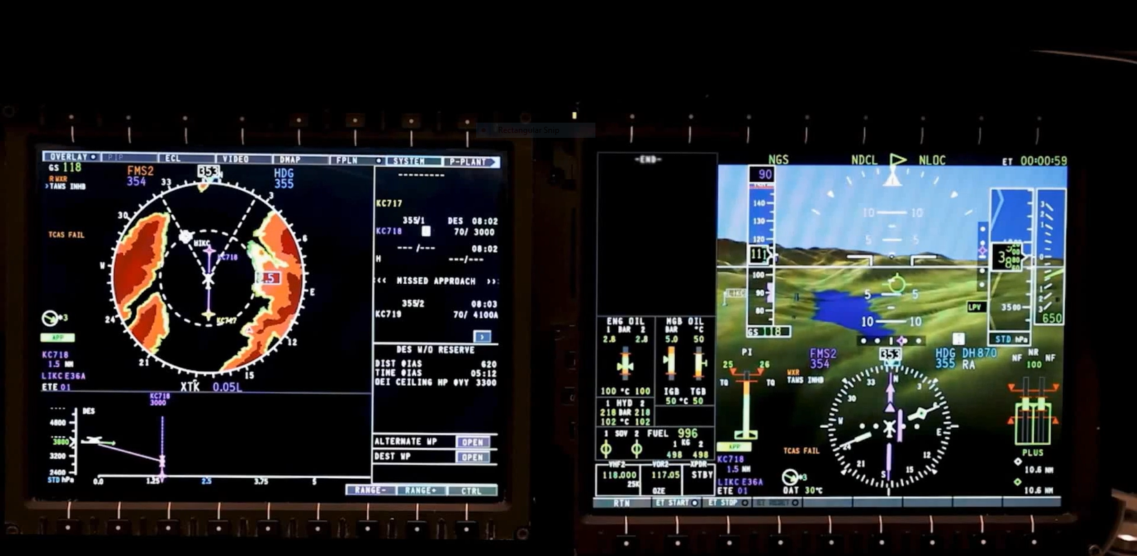
Leonardo Helicopters AW169 cockpit (avionic rig), showing the displayed information before jamming (Photo: Leonardo Helicopters).
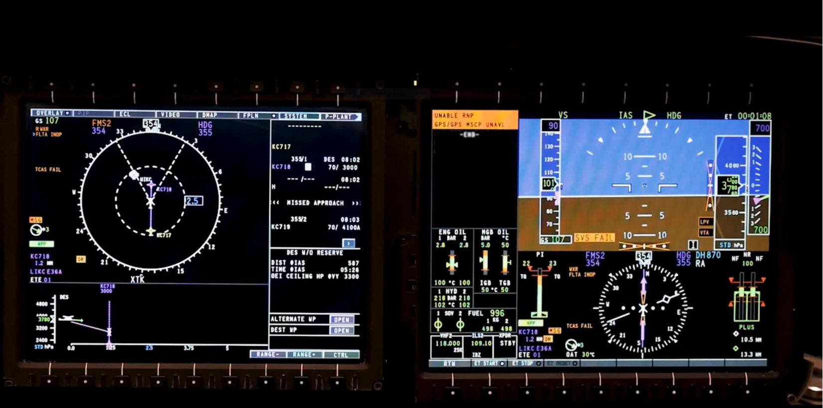
Leonardo Helicopters AW169 cockpit (avionic rig), showing the displayed information
after jamming (Photo: Leonardo Helicopters).
Procedures are the bridge between technology and human performance. Operators should publish clear policies for GNSS‑RFI operations, including decision points for suspending PinS or RNP procedures, guidance on immediate actions when integrity is lost, and criteria for diverting to alternate sites. For locations that are critical to public service (major hospitals, SAR bases, offshore installations) operators and procedure designers should explore whether contingency PinS segments, alternative routing, or hybrid procedures can be established to maintain access during periods of known interference. Even where full alternatives are not feasible, identifying pre‑planned safe holding areas, escape routes, and divert options can reduce cognitive load when anomalies occur.
Training closes the loop. Pilots should routinely practice recognition of jamming and spoofing symptoms, management of spurious alerts, and the disciplined use of fallback navigation, including inertial and barometric cues. Simulator sessions can reproduce similar workload and ambiguity scenarios that characterise real‑world events, anchoring early recognition, standard call‑outs, and crisp decision‑making. Because normalisation of deviance is a human‑factors hazard, training should emphasise that repeated nuisance alerts are not a license to disregard integrity warnings; they are a cue to apply the published response consistently.
Finally, a reporting culture is essential. Quick, high‑quality reports from crews and ANSPs turn isolated experiences into actionable intelligence, sharpening the interference picture and informing both tactical responses and strategic mitigations. Closing the loop with timely feedback – what was learned, what changed – reinforces the value of reporting and helps sustain engagement.
6. Practical recommendations for operators and crews
To keep recommendations to a minimum, the following are presented as short, targeted imperatives. They distil the suggested model above into actions that can be adopted without delay.
- Embed interference awareness into dispatch and briefing. Treat known or suspected GNSS disruption with the same discipline as adverse weather: evaluate routes and alternates, brief the likely effects on procedures, and carry a plan that can be executed without improvisation.
- Strengthen multi‑sensor navigation and integrity cross‑checking. Where possible, pair GNSS with inertial systems, support baro‑VNAV operations, and configure FMS logic to flag inconsistencies early. Evaluate avionics options that detect jamming and/or spoofing signatures or anomalous GNSS signal behaviour.
- Codify degraded‑FMS or standalone GNSS procedures. Define when to suspend an approach or terminate a PinS segment, how to transition to a safe altitude or hold, and how to coordinate with ATC and dispatch. Establish clear lines for diverting to alternates that offer more robust instrument access.
- Rehearse the human response. Use training to normalise the correct behaviours: early recognition, standard call‑outs, cross‑checking with independent sources, and timely go‑around or diversion decisions. Explicitly guard against normalisation of deviance by treating every integrity warning as actionable until proved otherwise.
- Develop fit‑for‑purpose contingencies at critical sites. Where feasible, design backup segments, identify safe escape and holding areas, and agree pre‑planned reroutes with ANSPs for hospitals, SAR bases, and offshore platforms where reliable access is essential.
- Report, share, and learn. Encourage prompt, high‑quality reporting of anomalies; participate in local and regional safety forums; and close the loop by feeding lessons learned back into procedures, training syllabi, and equipment choices.
7. A safety message for the rotorcraft community
GNSS interference is no longer exceptional. It is an operational reality that intersects directly with the public‑service missions helicopters are asked to perform.
The foundational insight is simple: a navigation architecture and operating model built for reliance must evolve toward resilience. That evolution is already underway – in regulatory initiatives, in infrastructure and monitoring, and in the avionics that crews rely on every day.
The task for rotorcraft operators is to bring those elements together in training, procedures, and design choices that preserve access, maintain safety margins, and keep lifesaving missions on track when satellite navigation cannot be taken for granted.
ANNEX. GNSS Interference: Rotorcraft Pilot Quick Reference Handbook
Adapted from the FAA GPS and GNSS Interference Resource Guide, Version 1, 2025.
1 – Recognition Cues (Jamming / Spoofing / Degradation)
Be alert for any of the following indications:
- Loss of GNSS guidance or sudden downgrade of navigation mode, e.g., Required Navigation Performance (RNP) to Dead Reckoning (DR).
- Receiver Autonomous Integrity Monitoring (RAIM[TF3] [MM4] ) / integrity alerts.
Note: RAIM is a GPS integrity function that checks whether satellite geometry and signals are reliable enough to support navigation. If integrity cannot be assured, it generates alerts such as “GPS NAV LOST”, “FMS NAV INVALID”, or Map shift / inconsistent position. - Abrupt position jumps, track deviations, or unstable guidance during departures, arrivals, or approaches.
- Multiple abnormal alerts appearing simultaneously or repeatedly.
These symptoms may appear progressively or abruptly
2 – Immediate Pilot Actions
If GNSS integrity is lost or suspected unreliable:
- Fly the aircraft first – stabilise attitude, altitude/height, and heading, and adapt speed if necessary.
- Cross‑check position using independent references (raw data, INS/IRS, baro‑VNAV cues, radar altimetry, visual cues if available).
- Discontinue the PinS / RNP APCH / LLR procedure if guidance becomes unreliable, and transition to visual or backup navigation as conditions permit.
- Establish a safe altitude or position using published or briefed escape/contingency instructions, or transition to a visual escape manoeuvre if conditions allow.
- Revert to alternate navigation means as per FMS/Operator guidance.
- Inform ATC: “GNSS INTERFERENCE / GNSS DEGRADATION”.
- Consider diverting if approach or route integrity cannot be restored in IMC or terrain‑constrained environments.
3 – Contingency Priorities
- Ensure terrain and obstacle clearance, using Minimum Sector Altitude (MSA) / Lowest Safe Altitude (LSALT) / PinS escape gradients / operator‑defined minima, as applicable.
- Request radar vectors or conventional navigation assistance, if available.
- If IMC and GNSS remains unreliable:
- Do not attempt a second GNSS‑based approach.
- Proceed to a suitable alternate where conventional or visual access is assured.
- If VMC:
- Continue visually only if definite, continuous ground reference is assured.
- Continue visually only if definite, continuous ground reference is assured.

Leonardo Helicopters AW189 Coastguard helicopters operated by Bristow
(Photo: Bristow).
4 – Crew Resource Management
- Pilot Flying (PF): Aircraft control, raw‑data navigation cross‑checks, escape path management.
- Pilot Monitoring (PM): Avionics monitoring, GNSS/RAIM status, ATC coordination, abnormal indication logging.
- Pilots and Air Traffic Controllers: Maintain effective CRM between pilots and ATC during RFI events ensures that both sides preserve a shared understanding of the situation. This common awareness enables a coordinated system response and prevents either party from managing the same hazard in isolation with incomplete information.
- Use clear verbalisation of anomalies to avoid normalisation of deviance.
- Apply standard callouts for integrity alerts and navigation downgrades.
5 – After Landing / Post‑Event
- Record event time, location, symptoms, flight phase, and weather and terrain context.
- Report via operator safety channels and national reporting systems as soon as possible.
- Include:
- Abnormal indications observed
- Procedure or phase of flight affected
- Crew actions taken
- Any visual references or backup navigation used
- Review operator guidance, recent NOTAMs, and interference reports for future missions in the same area.
6 – Core Safety Message
If GNSS doesn’t look right, it isn’t.
Treat every integrity warning as real.
Assess the situation, adapt speed and flight path as necessary, transition to backups or visual navigation, and report promptly.
Acronyms
Navigation and Systems
GNSS – Global Navigation Satellite System
RNP – Required Navigation Performance
DR – Dead Reckoning
RAIM – Receiver Autonomous Integrity Monitoring
GPS – Global Positioning System
FMS – Flight Management System
NAV – Navigation
PBN – Performance-Based Navigation
IRS – Inertial Reference System
INS – Inertial Navigation System
LNAV – Lateral Navigation
VNAV – Vertical Navigation
Baro-VNAV – Barometric Vertical Navigation
RA – Radar Altimeter (Radar Altimetry)
RFI – Radio‑Frequency Interference
SBAS – Satellite (or Space) Based Augmentation System
VOR – VHF Omnidirectional Range
DME – Distance Measuring Equipment
ILS – Instrument Landing System
FMS – Flight Management System
Terrain Awareness Warning System – TAWS
Procedures and Approaches
IMC – Instrument meteorological Conditions
IFR – Instrument Flight Rules
VFR – Visual Flight Rules
PinS – Point‑in‑Space (helicopter IFR approach procedure)
PBN – Performance-Based Navigation
RNAV – Area Navigation
RNP – Required Navigation Performance
RNP APCH – Required Navigation Performance Approach
RNP0.3 LLR – Required Navigation Performance 0.3 for Low‑Level Routes
LPV – Localiser Performance with Vertical Guidance
LLR – Low-Level Route
MSA – Minimum Sector Altitude
LSALT – Lowest Safe Altitude
IMC – Instrument Meteorological Conditions
VMC – Visual Meteorological Conditions
DME/DME – Distance Measuring Equipment/Distance Measuring Equipment
Required Navigation Performance 0.3 for Low‑Level Routes (RNP0.3 LLR)
Operations and Communications
ATC – Air Traffic Control
ATCO – Air Traffic Controller
ATM – Air Traffic Management
ANS – Air Navigation Services
ANSP – Air Navigation Service Providers
CNS – Communication, Navigation, and Surveillance
CAT – Commercial Air Transport
SAR – Search and Rescue
HEMS – Helicopter Emergency Medical Services
CRM – Crew Resource Management
CS – Certification Specifications
IFR – Instrument Flight Rules
PF – Pilot Flying
PM – Pilot Monitoring
NOTAM – Notice to Air Missions (previously Notice to Airmen)
R/T – Radiotelephony
Other
EPAS – European Plan for Aviation Safety
FIR – flight information regions
References
EASA and EUROCONTROL Action Plan to ensure safe operations during GNSS interference events | EASA.
EASA European Plan for Aviation Safety (EPAS) 2026 - 15th edition | EASA, Volume III ‘Safety Risk Portfolio’.
Safety Information Bulletin (SIB) 2022-02R3 Global Navigation Satellite System Outage and Alterations Leading to Communication / Navigation / Surveillance Degradation.
Global Navigation Satellite System (GNSS) Outages and Alterations | EASA
GNSS Jamming and Spoofing | SKYbrary Aviation Safety.
Supporting safe satellite-based rotorcraft operations | EUROCONTROL.
DGAC DSAC ST-GuideO1- PBN-RNAV_GNSS_ ENGv3.
EASA PBN Guide.
UK Ministry of Defence (MOD) and the Military Aviation Authority (MAA) RA 2380 – Performance Based Navigation Operations.
CAP1926 General Requirements and Guidance Material for the use of RNAV Substitution.
FAA GPS and GNSS Interference Resource Guide, Version 1, 2025.
ICAO / UNOOSA – GNSS Jamming & Spoofing Workshop Materials, 2024.
Acknowledgements
Grateful appreciation is extended to Tim Fauchon, BHA, Jim Evans, HeliOffshore, Gabriel Zuber, Airbus Helicopters, Stefano Locatelli and Cristian Durante, Leonardo Helicopters, and Jan Loncke, EASA, for reviewing this article and for their essential contributions.
Appreciation is also extended to Leonardo Helicopters, Airbus Helicopters, and Bristow for providing the pictures.
Further acknowledgement goes to ICAO, EUROCONTROL, the FAA, the DGAC, the UK CAA and the UK MoD for their material and inspiration.
Please log in or sign up to comment.