
AIS.TR.300 General – Aeronautical information products
Commission Implementing Regulation (EU) 2020/469
(a) Aeronautical information products intended for distribution shall include English text for those parts expressed in plain language, except those products intended to be distributed solely within a Member State.
(b) Place names shall be spelt in conformity with local usage and transliterated, when necessary, into the International Organization for Standardization (ISO) basic Latin alphabet.
(c) International Civil Aviation Organization (ICAO) abbreviations shall be used in the aeronautical information products whenever they are appropriate.
GM1 AIS.TR.300(b) General — Aeronautical information products
ED Decision 2020/008/R
PLACE NAMES
The phrase ‘when necessary’ means ‘for interoperability purposes’ e.g. in aeronautical information products that are intended to be processed by automated systems (NOTAM, data sets, etc.).
Chapter 1 – Aeronautical information in a standardised presentation
AIS.TR.305 Aeronautical information publication (AIP)
Commission Implementing Regulation (EU) 2020/469
(a) The AIP, AIP amendments and AIP supplements shall be provided as an ‘electronic AIP’ (eAIP). The eAIP shall allow for displaying on computer screen and printing on paper. In addition, the AIP, AIP amendments and AIP supplements may also be provided on paper.
(b) The AIP shall include:
(1) a statement of the competent authority responsible for the air navigation facilities, services or procedures covered by the AIP;
(2) the general conditions under which the services or facilities are available for use;
(3) a list of significant differences between the regulations and practices of the Member State and the related ICAO Standards and Recommended Practices (SAPRs) and Procedures;
(4) the choice made by a Member State in each significant case where an alternative course of action is provided for in the ICAO SARPs and procedures.
(c) The AIP shall contain information related to, and arranged under, the subject headings listed in Appendix 1.
(d) The issuing Member State and AIS provider shall be clearly indicated.
(e) When two or more Member States jointly provide an AIP, they shall be clearly indicated.
(f) Each AIP shall be self-contained and include a table of contents.
(g) An AIP shall be organised in three parts (GEN, ENR and AD), sections and subsections, except when the AIP, or a volume of the AIP, is designed to facilitate operational use in- flight, in which case the precise format and arrangement may be left to the discretion of the Member State provided that an adequate table of contents is included.
(h) Each AIP shall be dated.
(i) The date, consisting of the day, month (by name), and year, shall be the publication date and/or the effective date (AIRAC) of the information.
(j) When describing periods of activity, availability or operation, the applicable days and times shall be specified.
(k) Each AIP issued as a printed volume and each page of an AIP issued in a loose-leaf form shall be annotated to clearly indicate:
(1) the identity of the AIP;
(2) the territory covered and its subdivisions, when necessary;
(3) the identification of the issuing Member State and producing organisation (authority); and
(4) page numbers/chart titles.
(l) Any amendment to the printed volume of the AIP shall be made using replacement sheets.
AMC1 AIS.TR.305(a) Aeronautical information publication (AIP)
ED Decision 2020/008/R
ELECTRONIC FORM
The eAIP, eAIP amendments and eAIP supplements should be provided according to the EUROCONTROL ‘Specification for the Electronic Aeronautical Information Publication (eAIP)’ (edition 2.1, dated 6 October 2015).
AMC2 AIS.TR.305(a) Aeronautical information publication (AIP)
ED Decision 2020/008/R
ELECTRONIC AIP
When provided, the eAIP should be available on a physical distribution medium (CD, DVD, etc.) and/or online on the internet.
GM1 AIS.TR.305(a) Aeronautical information publication (AIP)
ED Decision 2020/008/R
PRINTED AIP
(a) A system of page numbering adaptable to the addition or deletion of sheets should be adopted. The page number should include:
(1) an identification of the part of the AIP;
(2) the section; and
(3) subsection, as applicable,
thus creating a separate set of numbers for each subject (e.g. GEN 2.1-3, ENR 4.1-1 or AD 2.2-3).
(b) If it is necessary by reason of bulk or for convenience, to publish an AIP in two or more parts or volumes, each of them will indicate that the remainder of the information is to be found in the other part(s) or volume(s).
(c) When the AIP is provided in more than one volume, each volume should include:
(1) a preface;
(2) a record of AIP amendments;
(3) a record of AIP supplements;
(4) a checklist of AIP pages; and
(5) a list of current hand amendments.
(d) When the AIP is published as one volume, the above-mentioned subsections should appear only in Part 1 — GEN and the annotation ‘not applicable’ should be entered against each of these subsections in Parts 2 and 3.
(e) The AIP should be published in loose-leaf form unless the complete publication is reissued at frequent intervals.
(f) Further guidelines for a harmonised AIP publication may be found in the EUROCONTROL ‘Guidelines for harmonised AIP publication and data set provision’ (edition 2.0, dated 23 May 2019).
AMC1 AIS.TR.305(c) Aeronautical information publication (AIP)
ED Decision 2022/015/R
INFORMATION PUBLISHED UNDER ‘AD 1.2.2 RUNWAY SURFACE CONDITION ASSESSMENT AND REPORTING, AND SNOW PLAN’
The following information, originated by the competent authority, should be published under AD 1.2.2 for all aerodromes open to public use in the State:
1. Organisation of the runway surface condition reporting and the winter service
An indication of the:
— organisation responsible for snow clearance and for assessing, improving and reporting runway surface conditions;
— general policy concerning operational priorities established for the clearance of movement areas;
— general policy concerning trend monitoring of surface friction characteristics, and what constitutes a complete survey.
2. Surveillance of movement areas
Indication of how surveillance of the movement areas is organised.
3. Surface condition assessment methods used; operations on specially prepared winter runways
Assessment methods and measurements taken. Reference should be made to the use of the runway condition assessment matrix, including the case of specially prepared winter runways, in the case the use of such runways has been approved.
4. Actions taken to maintain the usability of movement areas
A brief description of the methods used for clearing snow, slush, ice and standing water, e.g. plowing, sweeping or blowing, and details of any chemical methods employed for clearing movement areas. Information concerning when and how surface friction characteristics will be improved. General policy concerning coordination between aerodrome operators, air traffic services providers and the competent authorities to ensure compatibility between efficient snow clearance procedures and maximum utilisation of the aerodrome.
5. System and means of reporting
Reference should be made to the runway condition report.
6. The cases of runway closure
Indication of the general policy on closure of a runway.
7. Distribution of information about runway surface conditions
A short description of the system for distribution of information (NOTAM) for runways reaching the minimum friction value (slippery wet runways). Reference should be made to when NOTAMs for slippery wet runways are issued and updated.
A short description of the system for distribution of information about runway surface conditions (SNOWTAM, automatic terminal information service (ATIS) updating). Reference should be made to when SNOWTAMs are issued and updated. Furthermore, a description should be provided of how the upgraded/downgraded information is included in the SNOWTAM. In addition, a statement should be included when the information is disseminated with ATIS only.
AMC2 AIS.TR.305(c) Aeronautical information publication (AIP)
ED Decision 2022/015/R
INFORMATION PUBLISHED UNDER ‘AD 2.7 RUNWAY SURFACE CONDITION ASSESSMENT AND REPORTING AND SNOW PLAN’
The following information, originated by the respective aerodrome operator, should be published under AD 2.7.
(a) A reference to the content of AD.1.2.2 should be made for the runway surface condition assessment and reporting. Additional, aerodrome-specific information on runway surface condition assessment and reporting, complementing the information contained in AD 1.2.2 should be included.
(b) A detailed description of the equipment and operational priorities established for the clearance of aerodrome movement areas should be given, including:
1. Type(s) of clearing equipment
Indication as to whether the aerodrome is serviceable during all seasons of the year and, if not, the periods (months of the year) during which it may be unserviceable or must be used with caution, indicating the likely cause of unserviceability and the precautions to be taken. Information relating to snow removal should include:
(i) where no snow removal equipment is required, ‘Not applicable’ should be indicated;
(ii) where snow conditions exist, the types of equipment used should be indicated.
2. Clearance priorities
Indication of the priorities with regard to clearing of runway(s), taxiway(s) and apron(s).
3. Use of material for movement area surface treatment
Indication of the type of material used for movement area surface treatment, using the abbreviation/text or the material.
Where no material is used, ‘Not applicable’ should be indicated.
4. Specially prepared winter runways
Indication if specially prepared winter runways have been approved, including runway designators.
Where the use of specially prepared winter runways has not been approved, ‘Not applicable’ should be indicated.
5. Remarks
Any other relevant information not covered under this subsection.
AMC3 AIS.TR.305(c) Aeronautical information publication (AIP)
ED Decision 2022/015/R
INFORMATION FOR LED LIGHTS PUBLISHED UNDER ‘AD 2.14 APPROACH AND RUNWAY LIGHTING’
If the aerodrome operator provides information that light emitting diode (LED) lights are used as part of the approach and runway lighting system of the aerodrome, such information should be published in the ‘Remarks’. In such case, the information published should make clear, for each part of the lighting system, whether:
— LED lights are exclusively used for that part of the lighting system; or
— LED lights are used in combination with incandescent lights.
AMC4 AIS.TR.305(c) Aeronautical information publication (AIP)
ED Decision 2022/015/R
INFORMATION FOR VISUAL SEGMENT SURFACE (VSS) PENETRATION, PUBLISHED UNDER ‘AD 2.25’
If the VSS is penetrated, the information to be published under this section should clearly indicate the name of the affected procedure and the procedure minima affected.
The published information should be grouped per runway end.
In the case of no penetration, ‘Not applicable’ should be indicated.
GM1 AIS.TR.305(c) Aeronautical information publication (AIP)
ED Decision 2020/008/R
INFORMATION RELATED TO LOCATIONS
When listing locations, the city or town should be given in capital letters followed, where the facility is an aerodrome/heliport or is located at an aerodrome/heliport, by an oblique stroke and the name of the aerodrome/heliport in smaller capital letters or lower-case letters. Unless otherwise indicated, the list should be in alphabetical order.
GM2 AIS.TR.305(c) Aeronautical information publication (AIP)
ED Decision 2020/008/R
INFORMATION RELATED TO CHARTS, MAPS OR DIAGRAMS
(a) Charts, maps or diagrams should be used, when appropriate, to complement the AIP or serve as a substitute for the tabulations or text of the AIP.
(b) Where appropriate, charts produced in conformity with AIS.OR.325 may be used to fulfil this requirement.
GM3 AIS.TR.305(c) Aeronautical information publication (AIP)
ED Decision 2022/015/R
INFORMATION RELATED TO THE AIP DATA SET
When the AIP data set is provided, the following sections of the AIP may be left blank and a reference to the data set availability should be provided:
(a) ENR 2.1 FIR, UIR, TMA and CTA;
(b) ENR 3.1 Conventional navigation routes;
(c) ENR 3.2 Area navigation routes;
(d) ENR 3.3 Other routes;
(e) ENR 3.4 En route holding;
(f) ENR 4.1 Radio navigation aids — en route;
(g) ENR 4.4 Name-code designators for significant points;
(h) ENR 4.5 Aeronautical ground lights — en route;
(i) ENR 5.1 Prohibited, restricted and danger areas;
(j) ENR 5.2 Military exercise and training areas and air defence identification zone (ADIZ);
(k) ENR 5.3.1 Other activities of a dangerous nature;
(l) ENR 5.5 Aerial sporting and recreational activities;
(m) AD 2.17 Air traffic services airspace;
(n) AD 2.19 Radio navigation and landing aids;
(o) AD 3.16 Air traffic services airspace; and
(p) AD 3.18 Radio navigation and landing aids.
GM4 AIS.TR.305(c) Aeronautical information publication (AIP)
ED Decision 2020/008/R
INFORMATION RELATED TO THE OBSTACLE DATA SET
When the obstacle data set is provided, the following sections of the AIP may be left blank and a reference to the data set availability should be provided:
(a) ENR 5.4 Air navigation obstacles;
(b) AD 2.10 Aerodrome obstacles; and
(c) AD 3.10 Heliport obstacles.
GM5 AIS.TR.305(c) Aeronautical information publication (AIP)
ED Decision 2022/015/R
INFORMATION PUBLISHED REGARDING USE OF MATERIAL FOR MOVEMENT AREA SURFACE TREATMENT UNDER ‘AD 2.7 RUNWAY SURFACE CONDITION ASSESSMENT AND REPORTING AND SNOW PLAN’
The following list contains the abbreviations/words that may be published in the relevant section of the AIP regarding the use of material for movement area surface treatment, according to the information originated by the aerodrome operator:
(a) KAC, for potassium acetate fluids;
(b) KFOR, for potassium formate fluids;
(c) GAC, for glycerine acetate fluids;
(d) NAFO, for sodium formate solids;
(e) NAAC, for sodium acetate solids;
(f) EG, for ethylene glycol fluids;
(g) PG, for propylene glycol fluids;
(h) UREA; and
(i) SAND.
GM6 AIS.TR.305(c) Aeronautical information publication (AIP)
ED Decision 2022/015/R
INFORMATION FOR LED LIGHTS PUBLISHED UNDER ‘AD 2.14 APPROACH AND RUWNAY LIGHTING’
Examples of information published in the ‘Remarks’ indicating that light emitting diode (LED) lights are used as part of the approach and runway lighting system of the aerodrome, are shown below:
— ‘RWY 05, LED and incandescent lights used as part of the RWY edge lights on both sides of RWY’;
— ‘RWY 05, LED lights used for the centreline lighting system in the first 600 m; remaining length incandescent lights are used’;
— ‘RWY 05, LED lights used in the full length of the approach lighting system’.
GM7 AIS.TR.305(c) Aeronautical information publication (AIP)
ED Decision 2022/015/R
INFORMATION FOR VISUAL SEGMENT SURFACE (VSS) PENETRATION, PUBLISHED UNDER ‘AD 2.25’
In case of VSS penetration, the information published under AD 2.25 is limited to the name of the affected procedure and procedure minima affected; information about the obstacles themselves penetrating the VSS is not published under ‘AD 2.25’, as such information is meant to be published under ‘AD 2.10 Aerodrome obstacles’.
Commission Implementing Regulation (EU) 2020/469
(a) Any operationally significant changes to the AIP, in accordance with point AIS.OR.505, shall be issued under AIRAC and clearly identified as such.
(b) Each AIP amendment shall be allocated a serial number, which shall be consecutive.
(c) When an AIP amendment is issued, it shall include references to the serial number of the NOTAM which have been incorporated into the amendment.
(d) The most current update cycles applicable to AIP amendments shall be made publicly available.
(e) Recourse to hand amendments/annotations shall be kept to a minimum; the normal method of amendment shall be by reissuing or by replacement of pages.
(f) Each AIP amendment shall:
(1) include a checklist with the current dates and numbers of each loose-leaf page in the AIP; and
(2) provide a recapitulation of any outstanding hand amendments.
(g) New or revised information shall be identified by an annotation against it in the margin.
(h) Each AIP amendment page, including the cover sheet, shall contain a publication date and, when applicable, an effective date.
(i) The regular intervals between the AIP amendments shall be specified in Part 1 – General (GEN) of the AIP.
AMC1 AIS.TR.310(g) AIP amendments
ED Decision 2020/008/R
ANNOTATION
(a) The annotation in the margin should be done by a thick black vertical line or, where the change incorporated covers one line only or a part of a line, a thick black horizontal arrow.
(b) For aeronautical charts, the annotation should be made as a marginal note.
GM1 AIS.TR.310(h) AIP amendments
ED Decision 2020/008/R
EFFECTIVE TIME
When an effective time other than 00.00 UTC is used, the effective time should also be indicated.
Commission Implementing Regulation (EU) 2020/469
(a) The AIP supplement issued in printed form shall be provided by means of distinctive pages.
(b) The most current update cycles applicable to AIP supplements shall be made publicly available.
(c) Each AIP supplement shall be allocated a serial number which shall be consecutive and based on the calendar year.
(d) Whenever an AIP supplement is issued as a replacement of a NOTAM, a reference to the series and number of the NOTAM shall be included.
(e) A checklist of valid AIP supplements shall be issued at intervals of not more than one month, as part of the checklist of NOTAM and also with distribution as for the AIP supplements.
(f) Each AIP supplement page shall have a publication date. Each AIRAC AIP supplement page shall have both a publication and an effective date.
GM1 AIS.TR.315 AIP supplements
ED Decision 2020/008/R
ISSUE OF NOTAM
When there is not sufficient time for the distribution of an AIP supplement, a NOTAM may be issued.
AIS.TR.320 Aeronautical information circular (AIC)
Commission Implementing Regulation (EU) 2020/469
(a) The AIC shall be provided as an electronic document.
(b) The AIC shall be provided whenever it is desirable to promulgate:
(1) forecasts of important changes in the air navigation procedures, services and facilities;
(2) forecasts of implementation of new navigational systems;
(3) significant information derived from aircraft accident/incident investigation which has a bearing on flight safety;
(4) information on regulations related to the safeguarding of civil aviation against acts of unlawful interference that jeopardise the security of civil aviation;
(5) advice on medical matters of special interest to pilots;
(6) warnings to pilots concerning the avoidance of physical hazards;
(7) information on the effect of certain weather phenomena on aircraft operations;
(8) information on new hazards affecting aircraft handling techniques;
(9) information on regulations related to the carriage of restricted articles by air;
(10) references to the requirements of national and EU legislation and to the publication of changes therein;
(11) information on aircrew licensing arrangements;
(12) information on training of aviation personnel;
(13) information on the implementation of, or exemption from, requirements in national and EU legislation;
(14) advice on the use and maintenance of specific types of equipment;
(15) the actual or planned availability of new or revised editions of aeronautical charts;
(16) information on the carriage of communication equipment;
(17) explanatory information related to noise abatement;
(18) selected airworthiness directives;
(19) information on changes in NOTAM series or distribution, new editions of AIP or major changes in their content, coverage or format;
(20) advance information on the snow plan; and
(21) other information of a similar nature.
(c) The AIC shall not be used for information that qualifies for inclusion in AIP or NOTAM.
(d) The snow plan issued in accordance with point AD 1.2.2 of the AIP shall be supplemented by seasonal information to be issued as an AIC well in advance of the beginning of each winter – not less than one month before the normal onset of winter conditions.
(e) When the AIC is selected by the originating Member State for distribution beyond its territory, it shall have the same distribution as the AIP.
(f) Each AIC shall be allocated a serial number which shall be consecutive and based on the calendar year.
(g) In the event that an AIC is provided in more than one series, each series shall be separately identified by a letter.
(h) A checklist of AIC currently in force shall be issued at least once a year, with distribution as for the AIC.
(i) A checklist of AIC provided beyond the territory of a Member State shall be included in the NOTAM checklist.
AMC1 AIS.TR.320(a) Aeronautical information circular (AIC)
ED Decision 2020/008/R
ELECTRONIC FORM
When AICs are provided as part of the ‘electronic AIP’, they should comply with the EUROCONTROL ‘Specification for the Electronic Aeronautical Information Publication (eAIP)’ (edition 2.1, dated 6 October 2015).
GM1 AIS.TR.320(a) Aeronautical information circular (AIC)
ED Decision 2020/008/R
PRINTED FORM
Differentiation and identification of AIC topics according to subjects using colour coding should be practised where the numbers of AICs in force are sufficient to make identification in this form necessary. For example:
(a) white — administrative;
(b) yellow — ATC;
(c) pink — safety;
(d) mauve — danger area map; and
(e) green — maps/charts.
GM1 AIS.TR.320(c) Aeronautical information circular (AIC)
ED Decision 2020/008/R
GENERAL
(a) AICs are not used to promulgate aeronautical data and aeronautical information that qualify for inclusion in AIP (including amendments and supplements) or in NOTAM. Nevertheless, AICs can be used to provide detailed information and/or interpretation about data contained in those aeronautical information products.
(b) Consequently:
(1) an AIC is not used to promulgate aeronautical data that is part of the data catalogue; and
(2) the content of an AIC is not subject to the application of the DQRs.
(c) AICs can be made available with the electronic AIP for distribution purpose, as long as it is understood that they remain separate aeronautical information products.
GM1 AIS.TR.320(d) Aeronautical information circular (AIC)
ED Decision 2020/008/R
SNOW PLAN INFORMATION
The seasonal AIC on the snow plan may contain information such as that listed below:
(a) a list of aerodromes/heliports where during the coming winter the following are expected to be performed:
(1) snow clearance in accordance with the runway and taxiway systems; or
(2) planned snow clearing, deviating from the runway system (length, width and number of runways, affected taxiways and aprons or portions thereof);
(b) information concerning any centre designated to coordinate information on the current state of progress of clearance and on the current state of runways, taxiways and aprons;
(c) a division of the aerodromes/heliports into SNOWTAM distribution lists in order to avoid excessive NOTAM distribution;
(d) an indication, as necessary, of minor changes to the standing snow plan;
(e) a descriptive list of clearance equipment; and
(f) a listing of what will be considered as the minimum critical snow bank to be reported at each aerodrome/heliport at which reporting will commence.
Regulation (EU) 2020/469
(a) A NOTAM shall be issued when it is necessary to provide the following information:
(1) establishment of, closure of, or significant changes in the operation of aerodromes or heliports or runways;
(2) establishment of, withdrawal of, and significant changes in, the operation of aeronautical services;
(3) establishment of, withdrawal of, and significant changes in, the operational capability of radio navigation and air-ground communication services;
(4) unavailability of backup and secondary systems, having a direct operational impact;
(5) establishment of, withdrawal of, or significant changes to, visual aids;
(6) interruption of, or return to operation of, major components of aerodrome lighting systems;
(7) establishment of, withdrawal of, or significant changes to, procedures for air navigation services;
(8) occurrence or correction of major defects or impediments in the manoeuvring area;
(9) changes to, and limitations on, the availability of fuel, oil and oxygen;
(10) major changes to search and rescue (SAR) facilities and services available;
(11) establishment of, withdrawal of, or return to, operation of hazard beacons marking obstacles to air navigation;
(12) changes in regulations applicable in the Member State(s) concerned that require immediate action from an operational perspective;
(13) operational directives requiring immediate action or changes thereto;
(14) presence of hazards that affect air navigation;
(15) planned laser emissions, laser displays and search lights if pilots’ night vision is likely to be impaired;
(16) erecting or removal of, or changes to, obstacles to air navigation in the take-off/climb, missed approach, approach areas as well as on the runway strip;
(17) establishment or discontinuance of, including activation or deactivation, as applicable, or changes in, the status of prohibited, restricted or danger areas;
(18) establishment or discontinuance of areas or routes, or portions thereof, where the possibility of interception exists and where the maintenance of guard on the very high frequency (VHF) emergency frequency 121.500 MHz is required;
(19) allocation, cancellation or change of location indicators;
(20) changes in aerodrome/heliport rescue and firefighting (RFF) category;
(21) presence of, removal of, or significant changes in, hazardous conditions due to snow, slush, ice, radioactive material, toxic chemicals, volcanic ash deposition or water on the movement area;
(22) outbreaks of epidemics necessitating changes in notified requirements for inoculations and quarantine measures;
(23) forecasts of solar cosmic radiation, where provided;
(24) an operationally significant change in volcanic activity, the location, date and time of volcanic eruptions and/or the horizontal and vertical extent of a volcanic ash cloud, including direction of movement, flight levels and routes or portions of routes that could be affected;
(25) (release into the atmosphere of radioactive materials or toxic chemicals following a nuclear or chemical incident, the location, date and time of the incident, the flight levels and routes, or portions thereof, that could be affected, as well as the direction of movement;
(26) establishment of operations of humanitarian relief missions, together with procedures and/or limitations that affect air navigation;
(27) implementation of short-term contingency measures in cases of disruption, or partial disruption, of ATS and related supporting services;
(28) specific loss of integrity of satellite-based navigation systems.
(29) unavailability of a runway due to runway marking works or, if the equipment used for those works can be removed, a time lag required for making the runway available.’
(b) A NOTAM shall not be issued to provide any of the following information:
(1) routine maintenance work on aprons and taxiways that does not affect the safe movement of aircraft;
(2) temporary obstructions in the vicinity of aerodromes/heliports that do not affect the safe operation of aircraft;
(3) partial failure of aerodrome/heliport lighting facilities where such failure does not directly affect aircraft operations;
(4) partial temporary failure of air-ground communications when suitable alternative frequencies are available and are operative;
(5) lack of apron marshalling services, road traffic closures, limitations and control;
(6) the unserviceability of location, destination or other instruction signs on the aerodrome movement area;
(7) parachuting when in uncontrolled airspace under visual flight rules (VFR), or when in controlled airspace at promulgated sites or within danger or prohibited areas;
(8) training activities performed by ground units;
(9) unavailability of backup and secondary systems if these do not have an operational impact;
(10) limitations to airport facilities or general services, with no operational impact;
(11) national regulations not affecting general aviation;
(12) announcements or warnings about possible/potential limitations, with no operational impact;
(13) general reminders on already published information;
(14) availability of equipment for ground units, without information on the operational impact on airspace and facility users;
(15) information about laser emissions with no operational impact and about fireworks below the minimum flying heights;
(16) closure of parts of the movement area in connection with locally coordinated, planned work of duration of less than one hour;
(17) closure, changes, unavailability in the operation of aerodrome(s)/heliport(s) other than in the aerodrome(s)/ heliport(s) operation hours; and
(18) other non-operational information of a similar temporary nature.
(c) Except as provided for in points AIS.TR.330(f) and AIS.TR.330(g), each NOTAM shall contain the information in the order shown in the NOTAM format of Appendix 2.
(d) NOTAM text shall be composed of the significations/uniform abbreviated phraseology assigned to the ICAO NOTAM Code, complemented by ICAO abbreviations, indicators, identifiers, designators, call signs, frequencies, figures and plain language.
(e) All NOTAM shall be issued in English language. If necessary for domestic users, NOTAM may additionally be issued in national language.
(f) Information concerning snow, slush, ice, frost, standing water or water associated with snow, slush, ice or frost on the movement area shall be disseminated by means of SNOWTAM and shall contain the information in the order shown in the SNOWTAM format of Appendix 3a.
(g) Information concerning an operationally significant change to volcanic activity, volcanic eruption and/or volcanic ash cloud shall, when reported by means of an ASHTAM, contain the information in the order shown in the ASHTAM format of Appendix 4.
(h) When errors occur in a NOTAM, a NOTAM with a new number shall be issued to replace the erroneous NOTAM or the erroneous NOTAM shall be cancelled and a new NOTAM shall be issued.
(i) When a NOTAM is issued that cancels or replaces a previous NOTAM:
(1) the series and number/year of the previous NOTAM shall be indicated;
(2) the series, location indicator and subject of both NOTAM shall be the same.
(j) Only one NOTAM shall be cancelled or replaced by a NOTAM.
(k) Each NOTAM shall deal with only one subject and one condition of the subject.
(l) Each NOTAM shall be as brief as possible and compiled so that its meaning is clear without the need to refer to another document.
(m) A NOTAM containing permanent or temporary information of long duration shall include appropriate references to the AIP or AIP supplement.
(n) Location indicators included in the text of a NOTAM shall be those contained in ICAO Doc 7910 ‘Location Indicators’. A curtailed form of such indicators shall not be used. Where no ICAO location indicator is assigned to the location, its place name shall be entered in plain language.
(o) A series identified by a letter and a four-digit number followed by a stroke and a two-digit number for the year shall be allocated to each NOTAM. The four-digit number shall be consecutive and based on the calendar year.
(p) All NOTAM shall be divided in series based on subject, traffic or location or a combination thereof, depending on end-user needs. NOTAM for aerodromes allowing international air traffic shall be issued in international NOTAM series.
(q) If NOTAM are issued in both English and national language, the NOTAM series shall be organised so that the national language series are equivalent to the English language series in terms of content and numbering.
(r) The content and geographical coverage of each NOTAM series shall be stated in detail in the AIP, in point GEN 3.
(s) A checklist of valid NOTAM shall be regularly provided.
(t) One checklist NOTAM shall be issued for each series.
(u) A checklist NOTAM shall also refer to the latest AIP amendments, AIP supplements, data sets and, at least, to distributed AIC.
(v) A checklist NOTAM shall have the same distribution as the actual message series to which it refers and shall be clearly identified as a checklist.
(w) Series allocation shall be monitored and, if required, appropriate measures shall be taken to assure that no series reaches the maximum possible number of issued NOTAM before the end of a calendar year.
ED Decision 2020/008/R
USE OF OPADD
The origination and issuing of NOTAM should be in accordance with the EUROCONTROL ‘Guidelines — Operating Procedures for AIS Dynamic Data (OPADD)’ (edition 4.0, dated 17 April 2015).
ED Decision 2020/008/R
NOTAM CODE
The ICAO NOTAM Code together with significations/uniform abbreviated phraseology, and ICAO Abbreviations are those contained in ICAO Doc 8400 ‘Procedures for Air Navigation Services — ICAO Abbreviations and Codes (PANS-ABC)’.
ED Decision 2020/008/R
CHECKLIST
The checklist NOTAM may include the checklist of AIP Supplement (SUP).
Chapter 2 — Digital data sets
AIS.TR.335 General— Digital data sets
Commission Implementing Regulation (EU) 2020/469
(a) A standard for geographic information shall be used as a reference framework.
(b) A description of each available data set shall be provided in the form of a data product specification.
(c) A checklist of the available data sets, including their effective and publication dates, shall be made available to users to ensure that current data is being used.
(d) The checklist of data sets shall be made available through the same distribution mechanism as the one used for the data sets.
GM1 AIS.TR.335(a) General — Digital data sets
ED Decision 2020/008/R
STANDARD FOR GEOGRAPHIC INFORMATION
The ISO 19100 series of standards for geographic information may be used as a reference framework.
GM1 AIS.TR.335(b) General — Digital data sets
ED Decision 2020/008/R
DATA PRODUCT SPECIFICATION
(a) ISO Standard 19131 specifies the requirements and outline of data product specifications for geographic information. This is intended to facilitate and support the use and exchange of digital data sets between data providers and data users.
(b) The data product specification enables air navigation users to evaluate the products and determine whether they fulfil the requirements for their intended use (application).
(c) This may include an overview, specification scope, data product identification, data content and structure, reference system, data quality, data capture, data maintenance, data portrayal, data product delivery, additional information, and metadata.
AIS.TR.340 Metadata requirements
Commission Implementing Regulation (EU) 2020/469
The minimum metadata for each data set shall include:
(a) the name of the organisations or entities providing the data set;
(b) the date and time when the data set was provided;
(c) the validity of the data set; and
(d) any limitations on the use of the data set.
Commission Implementing Regulation (EU) 2020/469
(a) The AIP data set shall include data about the following subjects, including the properties indicated, if applicable:
|
Data subjects |
Associated properties as a minimum |
|
ATS airspace |
Type, name, lateral limits, vertical limits, class of airspace |
|
Special activity airspace |
Type, name, lateral limits, vertical limits, restriction, activation |
|
Route |
Identifier prefix, flight rules, designator |
|
Route segment |
Navigation specification, start point, end point, track, distance, upper limit, lower limit, minimum en-route altitude (MEA), minimum obstacle clearance altitude (MOCA), direction of cruising level, reverse direction of cruising level, required navigation performance |
|
Waypoint – en-route |
Reporting requirement, identification, location, formation |
|
Aerodrome/heliport |
Location indicator, name, International Air Transport Association (IATA) designator, served city, certification date, certification expiration date, if applicable, control type, field elevation, reference temperature, magnetic variation, airport reference point |
|
Runway |
Designator, nominal length, nominal width, surface type, strength |
|
Runway direction |
Designator, true bearing, threshold, take-off run available (TORA), take-off distance available (TODA), accelerate-stop distance available (ASDA), landing distance available (LDA), rejected TODA (for helicopters) |
|
Final approach and take-off area (FATO) |
Designation, length, width, threshold point |
|
Touchdown and lift-off area (TLOF) |
Designator, centre point, length, width, surface type |
|
Radio navigation aid |
Type identification, name, aerodrome served, hours of operation, magnetic variation, frequency/channel, position, elevation, magnetic bearing, true bearing, zero bearing direction |
(b) When a property is not defined for a particular occurrence of the subjects listed in (a), the AIP data subset shall include an explicit indication: ‘not applicable’.
GM1 AIS.TR.345(b) AIP data set
ED Decision 2020/008/R
PROPERTY
There may also be other reasons why a property is not provided, e.g. missing, unknown, withheld, etc.
AIS.TR.350 Terrain and obstacle data – General requirements
Commission Implementing Regulation (EU) 2020/469
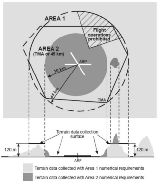
The coverage areas for sets of terrain and obstacle data shall be specified as:
(a) Area 1: the entire territory of a Member State;
(b) Area 2: within the vicinity of an aerodrome, subdivided as follows:
(1) Area 2a: a rectangular area around a runway which comprises the runway strip plus any clearway that exists;
(2) Area 2b: an area extending from the ends of Area 2a in the direction of departure, with a length of 10 km and a splay of 15 % to each side;
(3) Area 2c: an area extending outside Areas 2a and 2b at a distance of not more than 10 km from the boundary of Area 2a; and
(4) Area 2d: an area outside Areas 2a, 2b and 2c up to a distance of 45 km from the aerodrome reference point, or to an existing terminal manoeuvring area (TMA) boundary, whichever is nearer;
(c) Area 3: the area bordering an aerodrome movement area which extends horizontally from the edge of a runway to 90 m from the runway centre line and 50 m from the edge of all other parts of the aerodrome movement area; and
(d) Area 4: the area extending 900 m prior to the runway threshold and 60 m to each side of the extended runway centre line in the direction of the approach on a precision approach runway, Category II or III.
GM1 AIS.TR.350(d) Terrain and obstacle data — General requirements
ED Decision 2020/008/R
AREA 4
Where the terrain at a distance greater than 900 m (3 000 ft) from the runway threshold is mountainous or otherwise significant, the length of Area 4 should be extended to a distance not exceeding 2 000 m (6 500 ft) from the runway threshold.
Commission Implementing Regulation (EU) 2020/469
When terrain data sets are provided in accordance with point AIS.OR.355:
(a) terrain data sets shall contain the digital representation of the terrain surface in the form of continuous elevation values at all intersections of a defined grid, referenced to a common datum;
(b) a terrain grid shall be angular or linear and shall be of a regular or irregular shape;
(c) terrain data sets shall include spatial (position and elevation), thematic, and temporal aspects of the surface of the Earth, containing naturally occurring features, excluding obstacles;
(d) only one feature type, i.e. terrain, shall be provided;
(e) the following terrain feature attributes shall be recorded in the terrain data set:
(1) area of coverage;
(2) identification of the data originator er;
(3) data source identifier;
(4) acquisition method;
(5) post spacing;
(6) horizontal reference system;
(7) horizontal resolution;
(8) horizontal accuracy;
(9) horizontal confidence level;
(10) horizontal position;
(11) elevation;
(12) elevation reference;
(13) vertical reference system;
(14) vertical resolution;
(15) vertical accuracy;
(16) vertical confidence level;
(17) recorded surface;
(18) integrity;
(19) date and time stamp; and
(20) unit of measurement used;
(f) Within the area covered by a 10-km radius from the ARP, terrain data shall comply with the Area 2 numerical requirements;
(g) in the area between 10 km and the TMA boundary or a 45-km radius, whichever is smaller, data on terrain that penetrates the horizontal plane 120 m above the lowest runway elevation shall comply with the Area-2 numerical requirements;
(h) in the area between 10 km and the TMA boundary or a 45-km radius, whichever is smaller, data on terrain that does not penetrate the horizontal plane 120 m above the lowest runway elevation shall comply with the Area-1 numerical requirements; and
(i) in those portions of Area 2 where flight operations are prohibited due to very high terrain or other local restrictions and/or regulations, terrain data shall comply with the Area-1 numerical requirements.
Terrain data collection surfaces – Area 1 and Area 2
GM1 AIS.TR.355(e) Terrain data sets
ED Decision 2020/008/R
ATTRIBUTES
The following additional terrain feature attributes may be recorded in the terrain data set:
(a) surface type;
(b) penetration level; and
(c) known variations.
Commission Implementing Regulation (EU) 2020/469
When obstacle data sets are provided in accordance with point AIS.OR.360:
(a) obstacle data items are features that shall be represented in the data sets by points, lines or polygons;
(b) all defined obstacle feature types shall be provided and each of them shall be described according to the following list of attributes:
(1) area of coverage;
(2) identification of the data originator;
(3) data source identifier;
(4) obstacle identifier;
(5) horizontal accuracy;
(6) horizontal confidence level;
(7) horizontal position;
(8) horizontal resolution;
(9) horizontal extent;
(10) horizontal reference system;
(11) elevation;
(12) vertical accuracy;
(13) vertical confidence level;
(14) vertical resolution;
(15) vertical reference system;
(16) obstacle type;
(17) geometry type;
(18) integrity;
(19) date and time stamp;
(20) unit of measurement used;
(21) lighting; and
(22) marking;
(c) obstacle data for Areas 2 and 3 shall be collected in accordance with the following obstacle collection surfaces:
(1) the Area 2a obstacle collection surface has a height of 3 m above the nearest runway elevation measured along the runway centre line, and for those portions related to a clearway, if one exists, at the elevation of the nearest runway end;
(2) the Area 2b obstacle collection surface has a 1,2 % slope extending from the ends of Area 2a at the elevation of the runway end in the direction of departure, with a length of 10 km and a splay of 15 % to each side; obstacles less than 3 m in height above the ground need not be collected;
(3) the Area 2c obstacle collection surface has a 1,2 % slope extending outside Areas 2a and 2b at a distance of not more than 10 km from the boundary of Area 2a; the initial elevation of Area 2c shall be the elevation of the point of Area 2a at which it commences; obstacles less than 15 m in height above the ground need not be collected;
(4) the Area 2d obstacle collection surface has a height of 100 m above the ground; and
(5) the Area 3 obstacle collection surface extends 0.5 m above the horizontal plane passing through the nearest point on the aerodrome movement area;
(d) in those portions of Area 2 where flight operations are prohibited due to very high terrain or other local restrictions and/or regulations, obstacle data shall be collected and recorded in accordance with the Area 1 numerical requirements;
(e) the obstacle data product specification, supported by geographical coordinates for each aerodrome included within the dataset, shall describe the following areas:
(1) Areas 2a, 2b, 2c and 2d;
(2) the take-off flight path area; and
(3) the obstacle limitation surfaces;
(f) obstacle data sets shall contain the digital representation of the vertical and horizontal extent of the obstacles; and
(g) obstacles shall not be included in terrain data sets.
Obstacle data collection surfaces – Area 1 and Area 2
GM1 AIS.TR.360(b) Obstacle data sets
ED Decision 2020/008/R
ATTRIBUTES
The following additional obstacle feature attributes may be recorded in the obstacle data set:
(a) height;
(b) operations; and
(c) effectiveness.
AIS.TR.365 Aerodrome mapping data sets
Commission Implementing Regulation (EU) 2020/469
(a) Aerodrome mapping data sets shall contain the digital representation of aerodrome features.
(b) ISO standards for geographic information shall be used as a reference framework.
(c) Aerodrome mapping data products shall be described following the relevant data product specification standard.
(d) The content and structure of aerodrome mapping data sets shall be defined in terms of an application schema and a feature catalogue
GM1 AIS.TR.365 Aerodrome mapping data sets
ED Decision 2020/008/R
ADDITIONAL GUIDANCE
Further information concerning minimum requirements and reference material applicable to the content, origination, publication, and updating of aerodrome mapping information may be found in EUROCAE ED-99D ‘User Requirement for Aerodrome Mapping Information’, October 2015, and EUROCAE ED-119C ‘Interchange Standards for Terrain, Obstacle and Aerodrome Mapping Data’, October 2015.
GM1 AIS.TR.365(a) Aerodrome mapping data sets
ED Decision 2020/008/R
AERODROME FEATURES
Aerodrome features consist of attributes and geometries, which are characterised as points, lines or polygons. Examples include runway thresholds, taxiway guidance lines and parking stand areas.
GM2 AIS.TR.365(a) Aerodrome mapping data sets
ED Decision 2020/008/R
ADDITIONAL DATA
Aerodrome mapping data may be supported by electronic terrain and obstacle data for Area 3 in order to ensure consistency and quality of all geographical data related to the aerodrome.
GM3 AIS.TR.365(a) Aerodrome mapping data sets
ED Decision 2020/008/R
COMMON ACQUISITION TECHNIQUES
Electronic terrain and obstacle data pertaining to Area 3 as well as aerodrome mapping data may be originated using common acquisition techniques and managed within a single geographic information system (GIS).
GM1 AIS.TR.365(b) Aerodrome mapping data sets
ED Decision 2020/008/R
GENERAL
ISO Standard 19100 series on geographic information can be used as a reference framework.
GM1 AIS.TR.365(c) Aerodrome mapping data sets
ED Decision 2020/008/R
GENERAL
ISO Standard 19131 contains standards for data product specification.
GM1 AIS.TR.365(d) Aerodrome mapping data sets
ED Decision 2020/008/R
GENERAL
ISO Standard 19109 contains standards for application schemas, while ISO Standard 19110 describes the feature cataloguing methodology for geographic information.
AIS.TR.370 Instrument flight procedure data sets
Commission Implementing Regulation (EU) 2020/469
(a) Instrument flight procedure data sets shall contain the digital representation of instrument flight procedures.
(b) The instrument flight procedure data sets shall include data about the following subjects, including all of their properties:
(1) procedure;
(2) procedure segment;
(3) final approach segment;
(4) procedure fix;
(5) procedure holding;
(6) helicopter procedure specifics.
GM1 AIS.TR.370 Instrument flight procedure data sets
ED Decision 2020/008/R
GENERAL
Guidance on the instrument flight procedure data sets can be found in PANS-OPS, ICAO Doc 8168, Volume II – Part III, Section 2, Chapter 5.