Appendix 1

Regulation (EU) 2021/1338

Template for METAR and SPECI

Key:

M = inclusion mandatory;

C = inclusion conditional, dependent on meteorological conditions or method of observation;

O = inclusion optional.

Note 1: The ranges and resolutions for the numerical elements included in METAR and SPECI are provided in a separate table below this template.

Note 2: The explanations for the abbreviations can be found in ICAO Document 8400 Procedures for Air Navigation Services — Abbreviations and Codes (PANS-ABC).

Note 3: Row numbers in the ‘Ref.’ column are included only for clarity and ease of reference, and are not part of the METAR and SPECI.

Ref.

Element

Detailed content

Template(s)

1

Identification of the type of report (M)

Type of report (M)

METAR, METAR COR, SPECI or SPECI COR

2

Location indicator (M)

ICAO location indicator (M)

nnnn

3

Time of the observation (M)

Day and actual time of the observation in UTC (M)

nnnnnnZ

4

Identification of an automated or missing report (C)

Automated or missing report identifier (C)

AUTO or NIL

5

END OF METAR IF THE REPORT IS MISSING.

6

Surface wind (M)

Wind direction (M)

nnn or /// (36When a meteorological element is temporarily missing, or its value is considered temporarily as incorrect, it is replaced by a solidus (‘/’))

VRB


Wind speed (M)

[P]nn[n] or // (37When a meteorological element is temporarily missing, or its value is considered temporarily as incorrect, it is replaced by a solidus (‘/’))


Significant speed variations (C)

G[P]nn[n]


Units of measurement (M)

KT


Significant directional variations (C)

nnnVnnn

7

Visibility (M)

Prevailing or minimum visibility (M)

nnnn or //// (38When a meteorological element is temporarily missing, or its value is considered temporarily as incorrect, it is replaced by a solidus (‘/’))

C

A

V

O

K


Minimum visibility and direction of the minimum visibility (C)

nnnn[N] or nnnn[NE] or nnnn[E] or nnnn[SE] or nnnn[S] or nnnn[SW] or nnnn[W] or nnnn[NW]

8

Runway visual range (C) (39To be included if the visibility or the runway visual range is < 1 500 m for up to a maximum of four runways.)

Name of the element (M)

R


Runway (M)

nn[L]/or nn[C]/or nn[R]/


Runway visual range (M)

[P or M]nnnn or //// (40When a meteorological element is temporarily missing, or its value is considered temporarily as incorrect, it is replaced by a solidus (‘/’)1)


Runway visual range past tendency (C)

U, D or N

9

Present weather (C)

Intensity or proximity of present weather (C)

– or +

VC

Characteristics and type of present weather (M)

DZ or

RA or

SN or

SG or

PL or

DS or

SS or

FZDZ or

FZRA or

FZUP (41For automated reports only.) or

FC (42‘Heavy’ is used to indicate ‘tornado’ or ‘waterspout’; ‘moderate’ (no qualifier) to indicate ‘funnel cloud not reaching the ground’.) or

SHGR or

SHGS or

SHRA or

SHSN or

SHUP (43For automated reports only.) or

TSGR or

TSGS or

TSRA or

TSSN or

TSUP (44For automated reports only.) or

UP (45For automated reports only.)

FG or

BR or

SA or

DU or

HZ or

FU or

VA or

SQ or

PO or

TS or

BCFG or

BLDU or

BLSA or

BLSN or

DRDU or

DRSA or

DRSN or

FZFG or

MIFG or

PRFG or

// (46When a meteorological element is temporarily missing, or its value is considered temporarily as incorrect, it is replaced by a solidus (‘/’))

FG or

PO or

FC or

DS or

SS or

TS or

SH or

BLSN or

BLSA or

BLDU or

VA

10

Cloud (M)

Cloud amount and height of cloud base or vertical visibility (M)

FEWnnn or

SCTnnn or

BKNnnn or

OVCnnn or

FEW/// (47When a meteorological element is temporarily missing, or its value is considered temporarily as incorrect, it is replaced by a solidus (‘/’)) or

SCT/// (48When a meteorological element is temporarily missing, or its value is considered temporarily as incorrect, it is replaced by a solidus (‘/’)) or

BKN/// (49When a meteorological element is temporarily missing, or its value is considered temporarily as incorrect, it is replaced by a solidus (‘/’)) or

OVC/// (50When a meteorological element is temporarily missing, or its value is considered temporarily as incorrect, it is replaced by a solidus (‘/’)) or

///nnn (51When a meteorological element is temporarily missing, or its value is considered temporarily as incorrect, it is replaced by a solidus (‘/’)) or

////// (52When a meteorological element is temporarily missing, or its value is considered temporarily as incorrect, it is replaced by a solidus (‘/’))

VVnnn or

VV/// (53When a meteorological element is temporarily missing, or its value is considered temporarily as incorrect, it is replaced by a solidus (‘/’))

NSC

or NCD (54For automated reports only.)


Cloud type (C)

CB or

TCU or /// (55When a meteorological element is temporarily missing, or its value is considered temporarily as incorrect, it is replaced by a solidus (‘/’)),(56In the case of automated reports, solidi (‘///’) may replace the relevant cloud type, as appropriate, dependent on the capability of the automatic observing system. Furthermore, solidi may replace cloud amount and/or cloud height of reported CB or TCU layer.)

11

Air and dew-point temperature (M)

Air and dew-point temperature (M)

[M]nn/[M]nn or ///[M]nn (57When a meteorological element is temporarily missing, or its value is considered temporarily as incorrect, it is replaced by a solidus (‘/’)) or [M]nn/// (58When a meteorological element is temporarily missing, or its value is considered temporarily as incorrect, it is replaced by a solidus (‘/’)) or ///// (59When a meteorological element is temporarily missing, or its value is considered temporarily as incorrect, it is replaced by a solidus (‘/’))

12

Pressure values (M)

Name of the element (M)

Q

QNH (M)

nnnn or //// (60When a meteorological element is temporarily missing, or its value is considered temporarily as incorrect, it is replaced by a solidus (‘/’))

13

Supplementary information (C)

Recent weather (C)

RERASN or REFZDZ or REFZRA or REDZ or RE[SH]RA or RE[SH]SN or RESG or RESHGR or RESHGS or REBLSN or RESS or REDS or RETSRA or RETSSN or RETSGR or RETSGS or RETS or REFC or REVA or REPL or REUP (61For automated reports only.) or REFZUP (62For automated reports only.) or RETSUP (63For automated reports only.) or RESHUP (64For automated reports only.) or RE// (65When a meteorological element is temporarily missing, or its value is considered temporarily as incorrect, it is replaced by a solidus (‘/’))


Wind shear (C)

WS Rnn[L] or WS Rnn[C] or WS Rnn[R] or WS ALL RWY


Sea-surface temperature and state of the sea or significant wave height (C)

W[M]nn/Sn or W///Sn (66When a meteorological element is temporarily missing, or its value is considered temporarily as incorrect, it is replaced by a solidus (‘/’)) or W[M]nn/S/ (67When a meteorological element is temporarily missing, or its value is considered temporarily as incorrect, it is replaced by a solidus (‘/’)) or W[M]nn/Hn[n][n] or W///Hn[n][n] (68When a meteorological element is temporarily missing, or its value is considered temporarily as incorrect, it is replaced by a solidus (‘/’)) or W[M]nn/H/// (69When a meteorological element is temporarily missing, or its value is considered temporarily as incorrect, it is replaced by a solidus (‘/’))

14

Trend forecast (O)

Change indicator (M)

NOSIG

BECMG or TEMPO


Period of change (C)

FMnnnn and/or

TLnnnn

or

ATnnnn


Wind (C) 

nnn[P]nn[G[P]nn]KT


Prevailing visibility (C) 

nnnn

C

A

V

O

K


Weather phenomenon:

intensity (C)

– or +

N

S

W


Weather phenomenon:

characteristics and

type (C)

DZ or RA or SN or SG or PL or DS or SS or

FZDZ or FZRA or SHGR or SHGS or SHRA or SHSN or TSGR or TSGS or TSRA or TSSN

FG or BR or SA or DU or HZ or FU or VA or SQ or PO or FC or TS or BCFG or BLDU or BLSA or BLSN or DRDU or DRSA or DRSN or FZFG or MIFG or PRFG


Cloud amount and height of cloud base or vertical visibility (C)

FEWnnn or

SCTnnn

or

BKNnnn

or

OVCnnn

VVnnn or

VV///

N

S

C


Cloud type (C)

CB or TCU


Ranges and resolutions for the numerical elements included in METAR and SPECI

Ref.

Elements

Range

Resolution

1

Runway:

(no units)

01–36

1

2

Wind direction:

°true

000–360

10

3

Wind speed:

KT

00–99

P99

1

N/A (100 or greater)

4

Visibility:

M

0000–0750

50


M

0800–4 900

100


M

5 000–9 000

1 000


M

10 000 or greater

0 (fixed value: 9 999)

5

Runway visual range:

M

0000–0375

25


M

0400–0750

50


M

0800–2 000

100

6

Vertical visibility:

100’s FT

000–020

1

7

Clouds: height of cloud base:

100’s FT

000–099

100-200

1

10

8

Air temperature:

Dew-point temperature:


°C

–80 – +60

1

9

QNH: 

hPa

0850–1 100

1

10

Sea-surface temperature:

°C

–10 – +40

1

11

State of the sea: 

(no units)

0–9

1

12

Significant wave height:

M

0–999

0,1

GM1 to Appendix 1 ‘Template for METAR and SPECI’

ED Decision 2022/004/R

METAR AND SPECI — EXAMPLES OF ELEMENTS

Non-exhaustive examples of the different elements used in the formulation of METAR and SPECI are provided below.

METAR and SPECI — examples of elements

Note 1: Consult the ‘Template for METAR and SPECI’ (Appendix 1 to Annex V (Part-MET) to Regulation (EU) 2017/373) to identify the mandatory (M), the conditional (C) or the optional (O) elements.

Note 2: The ranges and resolutions for the numerical elements included in the METAR and SPECI are provided in Appendix 1 to Annex V (Part-MET) to Regulation (EU) 2017/373.

Note 3: The row numbers in the ‘Ref.’ column are included only for clarity and ease of reference, and are not part of the METAR and SPECI. They do not correlate with the ‘Ref.’ column in the ‘Template for METAR and SPECI’ in Appendix 1 to Annex V (Part-MET) to Regulation (EU) 2017/373. Refer to the ‘Element’ column when cross-referencing.

Ref.

Element

Examples

1

Identification of the type of report

METAR

METAR COR

SPECI

2

ICAO location indicator

YUDO

3

Time of the observation

221630Z

4

Identification of an automated report or a missing report

AUTO

NIL

5

Surface wind

24008KT

VRB02KT

19012KT

00000KT

140P99KT

12006G18KT

24016G28KT

02010KT 350V070

///10KT

240//KT

/////KT

6

Visibility

0350

7000

9999

0800

////

2000 1200NW

6000 2800E

6000 2800

CAVOK (70Replacing visibility, runway visual range, present weather, and cloud elements, when applicable.)

7

Runway visual range

R32/0400

R12R/1700

R16L/0650 R16C/0500

R16R/0450 R17L/0450

R14L/P2000

R10/M0050

R16L///// R10/////

R08L///// R08R/0400

R12/1100U

R26/0550N R20/0800D

R12/0700

8

Present weather

RA

HZ

VCFG

+TSRA

FG

VCSH

+DZ

VA

VCTS

–SN

MIFG

VCBLSA

+TSRASN

–SNRA

DZ FG

+SHSN BLSN

UP

FZUP

//

9

Cloud

FEW015

SCT010 OVC020

BKN016TCU

SCT008 BKN025CB

BKN025///

//////CB

NSC

NCD

VV005

VV///

BKN///

///015

/////////

//////

BKN///TCU

10

Air temperature and
dew-point temperature

17/10

02/M08

M01/M10

///10

17///

/////

11

Pressure values

Q0995

Q1022

Q////

12

Supplementary information

REFZRA

RETSRA


WS R03

WS ALL RWY

WS R18C


W15/S2

W12/H75

W///S3

WM01/S/

W///H104

W17/H///

W///H///

W///S/

13

Trend forecast

NOSIG

BECMG FEW020

TEMPO 25036G50KT

BECMG FM1030 TL1130 CAVOK

BECMG TL1700 0800 FG

BECMG AT1800 9000 NSW

BECMG FM1900 0500 +SNRA

BECMG FM1100 SN TEMPO FM1130 BLSN

TEMPO FM0330 TL0430 FZRA

TEMPO TL1200 0600 BECMG AT1200 8000 NSW NSC

BECMG AT1130 OVC010

TEMPO TL1530 +SHRA BKN012CB

Appendix 2

Regulation (EU) 2017/373

Fixed areas of coverage of WAFS forecasts in chart form
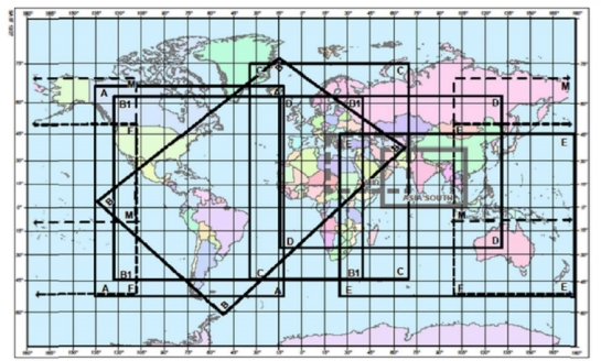
C:\Users\matiles\Desktop\Mercator-projection.jpgMercator projection

CHART

LATITUDE

LONGITUDE


CHART

LATITUDE

LONGITUDE

A

N6700

W13724


D

N6300

W01500

A

N6700

W01236


D

N6300

E13200

A

S5400

W01236


D

S2700

E13200

A

S5400

W13724


D

S2700

W01500

ASIA

N3600

E05300


E

N4455

E02446

ASIA

N3600

E10800


E

N4455

E18000

ASIA

0000

E10800


E

S5355

E18000

ASIA

0000

E05300


E

S5355

E02446

B

N0304

W13557


F

N5000

E10000

B

N7644

W01545


F

N5000

W11000

B

N3707

E06732


F

S5242

W11000

B

S6217

W05240


F

S5242

E10000

B1

N6242

W12500


M

N7000

E10000

B1

N6242

E04000


M

N7000

W11000

B1

S4530

E04000


M

S1000

W11000

B1

S4530

W12500


M

S1000

E10000

C

N7500

W03500


MID

N4400

E01700

C

N7500

E07000


MID

N4400

E07000

C

S4500

E07000


MID

N1000

E07000

C

S4500

W03500


MID

N1000

E01700

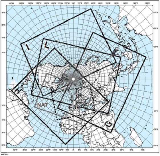
Polar stereographic projection (northern hemisphere)

C:\Users\matiles\Desktop\Polar-stereographic.jpg

CHART

LATITUDE

LONGITUDE


CHART

LATITUDE

LONGITUDE

EUR

N4633

W05634


I

N1912

E11130

EUR

N5842

E06824


I

N3330

W06012

EUR

N2621

E03325


I

N0126

W12327

EUR

N2123

W02136


I

S0647

E16601

G

N3552

W02822


L

N1205

E11449

G

N1341

E15711


L

N1518

E04500

G

S0916

E10651


L

N2020

W06900

G

S0048

E03447


L

N1413

W14338

H

N3127

W14836


NAT

N4439

W10143

H

N2411

E05645


NAT

N5042

E06017

H

N0127

W00651


NAT

N1938

E00957

H

N0133

W07902


NAT

N1711

W05406

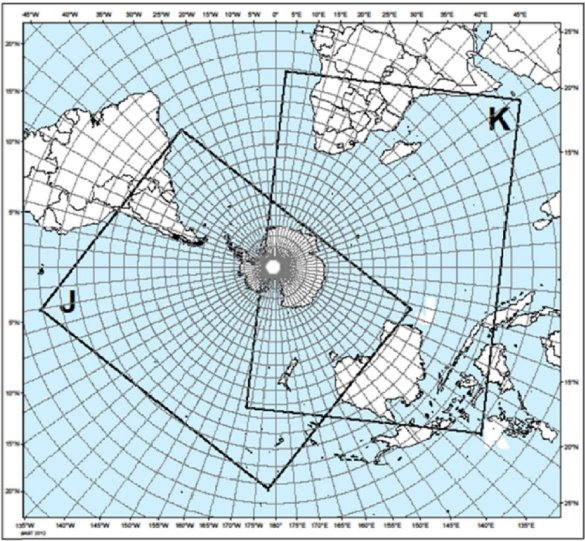
Polar stereographic projection (southern hemisphere)

C:\Users\matiles\Desktop\Polar-stereographic-south.jpg

CHART

LATITUDE

LONGITUDE

J

S0318

W17812

J

N0037

W10032

J

S2000

W03400

J

S2806

E10717

K

N1255

E05549

K

N0642

E12905

K

S2744

W16841

K

S1105

E00317

Appendix 3

Regulation (EU) 2021/1338

Template for TAF

Key:

M = inclusion mandatory;

C = inclusion conditional, dependent on meteorological conditions or method of observation;

O = inclusion optional.

Note 1: The ranges and resolutions for the numerical elements included in TAF are provided in a separate table below this template.

Note 2: The explanations for the abbreviations can be found in ICAO Doc 8400 Procedures for Air Navigation Services — ICAO Abbreviations and Codes (PANS-ABC).

Note 3: Row numbers in the ‘Ref.’ column are included only for clarity and ease of reference, and are not part of the TAF.

Ref.

Element

Detailed content

Template(s)

1

Identification of the type of forecast (M)

Type of forecast (M)

TAF or TAF AMD or TAF COR

2

Location indicator (M)

ICAO location indicator (M)

nnnn

3

Time of issue of the forecast (M)

Day and time of issue of the forecast in UTC (M)

nnnnnnZ

4

Identification of a missing forecast (C)

Missing forecast identifier (C)

NIL

5

END OF TAF IF THE FORECAST IS MISSING.

6

Days and period of validity of the forecast (M)

Days and period of validity of the forecast in UTC (M)

nnnn/nnnn

7

Identification of a cancelled forecast (C)

Cancelled forecast identifier (C)

CNL

8

END OF TAF IF THE FORECAST IS CANCELLED.

9

Surface wind (M)

Wind direction (M)

nnn or VRB

Wind speed (M)

[P]nn[n]

Significant speed variations (C)

G[P]nn[n]

Units of measurement (M)

KT

10

Visibility (M)

Prevailing visibility (M)

nnnn

C

A

V

O

K

11

Weather (C)

Intensity of weather phenomena (C) (71To be included whenever applicable. No qualifier for moderate intensity.)

– or +


Characteristics and type of weather phenomena (C)

DZ or RA or

SN or SG or

PL or DS or

SS or FZDZ or

FZRA or SHGR or

SHGS or SHRA or

SHSN or TSGR or

TSGS or TSRA or

TSSN

FG or

BR or

SA or

DU or

HZ or

FU or

VA or

SQ or

PO or

FC or

TS or

BCFG or

BLDU or

BLSA or

BLSN or

DRDU or

DRSA or

DRSN or

FZFG or

MIFG or

PRFG

12

Cloud (M) (72Up to four cloud layers.)

Cloud amount and height of base or vertical visibility (M)

FEWnnn

or

SCTnnn or

BKNnnn or

OVCnnn

VVnnn

or

VV///

N

S

C

Cloud type (C)

CB or TCU

13

Temperature (O) (73Consisting of up to a maximum of four temperatures (two maximum temperatures and two minimum temperatures).)

Name of the element (M)

TX

Maximum temperature (M)

[M]nn/

Day and time of occurrence of the maximum temperature (M)

nnnnZ

Name of the element (M)

TN

Minimum temperature (M)

[M]nn/

Day and time of occurrence of the minimum temperature (M)

nnnnZ

14

Expected significant changes to one or more of the above elements during the period of validity (C)

Change or probability indicator (M)

PROB30 [TEMPO] or PROB40 [TEMPO] or BECMG or TEMPO or FM


Period of occurrence or change (M)

nnnn/nnnn or nnnnnn


Wind (C)

nnn[P]nn[G[P]nn]KT

or

VRBnnKT


Prevailing visibility (C)

nnnn

C

A

V

O

K


Weather phenomenon: intensity (C)

– or +

N

S

W


Weather phenomenon: characteristics and type (C)

DZ or

RA or

SN or

SG or

PL or

DS or

SS or

FZDZ or

FZRA or

SHGR or

SHGS or

SHRA or

SHSN or

TSGR or

TSGS or

TSRA or

TSSN

FG or

BR or

SA or

DU or

HZ or

FU or

VA or

SQ or

PO or

FC or

TS or

BCFG or

BLDU or

BLSA or

BLSN or

DRDU or

DRSA or

DRSN or

FZFG or

MIFG or

PRFG

15


Cloud amount and height of base or vertical visibility (C)

FEWnnn or

SCTnnn or

BKNnnn or

OVCnnn

VVnnn

or

VV///

N

S

C


Cloud type (C)

CB or TCU

Ranges and resolutions for the numerical elements included in TAF

Ref.

Elements

Range

Resolution

1

Wind direction:

° true

000–360

10

2

Wind speed:

KT

00–99

1

3

Visibility:

M

0000–0750

50


M

0800–4 900

100


M

5 000–9 000

1 000


M

10 000 or greater

0 (fixed value: 9 999)

4

Vertical visibility:

100’s FT

000–020

1

5

Cloud: height of cloud base:

100’s FT

000–099

100–200

1

10

6

Air temperature (maximum and minimum):  

°C

–80 – +60

1’

GM1 to Appendix 3 ‘Template for TAF’

ED Decision 2022/004/R

TAF — EXAMPLES OF ELEMENTS

Non-exhaustive examples of the different elements used in the formulation of TAF are provided below.

TAF — examples of elements

Note 1: Consult the ‘Template for TAF’ (Appendix 3 to Annex V (Part-MET) to Regulation (EU) 2017/373) to identify the mandatory (M), the conditional (C) or the optional (O) elements.

Note 2: The ranges and resolutions for the numerical elements included in TAF are provided in Appendix 3 to Annex V (Part-MET) to Regulation (EU) 2017/373.

Note 3: The row numbers in the ‘Ref.’ column are included only for clarity and ease of reference, and are not part of the TAF. They do not correlate with the ‘Ref.’ column in the ‘Template for TAF’ of Appendix 3 to Annex V (Part-MET) to Regulation (EU) 2017/373. Refer to the ‘Element’ column when cross-referencing.

Ref.

Element

Examples

1

Identification of the type of forecast

TAF

TAF AMD

TAF COR

2

ICAO location indicator

YUDO

3

Time of issue of the forecast

160000Z

4

Identification of a missing forecast

NIL

5

Days and period of validity of the forecast

0812/0918

6

Identification of a cancelled forecast

CNL

7

Surface wind

24008KT

VRB02KT

19010KT

00000KT

140P99KT

24016G28KT

8

Visibility

0350

7000

9999

CAVOK (74Replacing visibility, runway visual range, forecast weather and cloud elements, when applicable.)

9

Forecast weather

RA

HZ

+TSRA

FG

–FZDZ PRFG

+TSRASN

SNRA BR

10

Cloud

FEW010

OVC020

NSC

SCT005 BKN012

SCT008 BKN025CB

VV005

VV///

11

Temperature

TX25/1013Z TN09/1005Z

TX05/2112Z TNM02/2103Z

TX22/1115Z TN10/1204Z TX26/1215Z

TX26/1215Z TN11/1306Z Tx25/1315Z

12

Expected significant changes to one or more of the above elements during the period of validity of the forecast

TEMPO 0815/0818 25034G50KT

TEMPO 2212/2214 17012G26KT 1000 TSRA SCT010CB BKN020

BECMG 3010/3011 00000KT 2400 OVC010

PROB30 1412/1414 0800 FG

BECMG 1412/1414 RA

TEMPO 2503/2504 FZRA

TEMPO 0612/0615 BLSN

PROB40 TEMPO 2923/3001 0500 FG

FM051230 15008KT 9999 BKN020

BECMG 1618/1620 8000 NSW NSC

BECMG 2306/2308 SCT015CB BKN020

Appendix 4

Regulation (EU) 2021/1338

Template for wind shear warnings

Key:

M = inclusion mandatory;

C = inclusion conditional, whenever applicable.

Note 1: The ranges and resolutions for the numerical elements included in wind shear warnings are shown in Appendix 8.

Note 2: The explanations for the abbreviations can be found in ICAO Doc 8400 Procedures for Air Navigation Services — ICAO Abbreviations and Codes (PANS-ABC).

Note 3: Row numbers in the ‘Ref.’ column are included only for clarity and ease of reference, and are not part of the wind shear warning.

Ref.

Element

Detailed content

Template(s)

1

Location indicator of the aerodrome (M)

Location indicator of the aerodrome

nnnn

2

Identification of the type of message (M)

Type of message and sequence number

WS WRNG [n]n

3

Time of origin and validity period (M)

Day and time of issue and, where applicable, validity period in UTC

nnnnnn [VALID TL nnnnnn] or

[VALID nnnnnn/nnnnnn]

4

IF THE WIND SHEAR WARNING IS TO BE CANCELLED, SEE DETAILS AT THE END OF THE TEMPLATE.

5

Phenomenon (M)

Identification of the phenomenon and its location

[MOD] or [SEV] WS IN APCH or

[MOD] or [SEV] WS [APCH] RWYnnn or

[MOD] or [SEV] WS IN CLIMB-OUT or

[MOD] or [SEV] WS CLIMB-OUT RWYnnn or

MBST IN APCH or

MBST [APCH] RWYnnn or

MBST IN CLIMB-OUT or

MBST CLIMB-OUT RWYnnn

6

Observed, reported or forecast phenomenon (M)

Identification whether the phenomenon is observed or reported and expected to continue, or forecast

REP AT nnnn nnnnnnnn or

OBS [AT nnnn] or

FCST

7

Details of the phenomenon (C)

Description of the phenomenon causing the issuance of the wind shear warning

SFC WIND: nnn/nnKT nnnFT –

WIND: nnn/nnKT or

nnKT LOSS nnNM (or nnKM) FNA RWYnn or

nnKT GAIN nnNM (or nnKM) FNA RWYnn


OR


8

Cancellation of wind shear warning

Cancellation of wind shear warning referring to its identification

CNL WS WRNG [n]n nnnnnn/nnnnnn

GM1 to Appendix 4 ‘Template for wind shear warnings’

ED Decision 2022/004/R

WIND SHEAR WARNINGS — EXAMPLES OF ELEMENTS

Non-exhaustive examples of the different elements used in the formulation of wind shear warnings are provided below.

Wind shear warnings — examples of elements

Note 1: Consult the ‘Template for wind shear warnings’ (Appendix 4 to Annex V (Part-MET) to Regulation (EU) 2017/373) to identify the mandatory (M), the conditional (C) or the optional (O) elements.

Note 2: The ranges and resolutions for the numerical elements included in wind shear warnings are provided in Appendix 8 to Annex V (Part-MET) to Regulation (EU) 2017/373.

Note 3: The row numbers in the ‘Ref.’ column are included only for clarity and ease of reference, and are not part of the wind shear warning. They do not correlate with the ‘Ref.’ column in the ‘Template for wind shear warnings’ of Appendix 4 to Annex V (Part-MET) to Regulation (EU) 2017/373. Refer to the ‘Element’ column when cross-referencing.

Ref.

Element

Example

1

Location indicator of the aerodrome

YUCC

2

Identification of the type of message

WS WRNG 1

3

Time of origin and validity period

211230 VALID TL 211330

221200 VALID 221215/221315

4

Phenomenon

WS APCH RWY12

MOD WS RWY34

WS IN CLIMB-OUT

MBST APCH RWY26

MBST IN CLIMB-OUT

5

Observed, reported or forecast phenomenon

REP AT 1510 B747

OBS AT 1205

FCST

6

Details of the phenomenon

SFC WIND: 320/10KT 200FT-WIND: 360/26KT

30KT LOSS 2NM FNA RWY13


OR


7

Cancellation of the wind shear warning

CNL WS WRNG 1 211230/211330

Appendix 5

Regulation (EU) 2021/1338

Template for SIGMET and AIRMET

Key:

M = inclusion mandatory;

C = inclusion conditional, whenever applicable; and

Note 1: The ranges and resolutions for the numerical elements included in SIGMET or AIRMET are shown in Appendix 8.

Note 2: Severe or moderate icing (SEV ICE, MOD ICE) and severe or moderate turbulence (SEV TURB, MOD TURB) associated with thunderstorms, cumulonimbus clouds or tropical cyclones should not be included.

Note 3: Row numbers in the ‘Ref.’ column are included only for clarity and ease of reference, and are not part of the SIGMET or AIRMET.

Ref.

Element

Detailed content

SIGMET template

AIRMET template

1

Location indicator of FIR/CTA (M)

ICAO location indicator of the ATS unit serving the FIR or CTA to which the SIGMET/AIRMET refers

nnnn

2

Identification (M)

SIGMET or AIRMET identification and sequence number

SIGMET nnn

AIRMET [n][n]n

3

Validity period (M)

Day-time groups indicating the period of validity in UTC

VALID nnnnnn/nnnnnn

4

Location indicator of MWO (M)

Location indicator of MWO originating the SIGMET or AIRMET with a separating hyphen

nnnn–

5

New line

6

Name of the FIR/CTA (M)

Location indicator and name of the FIR/CTA for which the SIGMET/AIRMET is issued

nnnn nnnnnnnnnn FIR

or

UIR

or

FIR/UIR

or nnnn nnnnnnnnnn CTA

nnnn nnnnnnnnnn

FIR[/n]

7

IF THE SIGMET OR AIRMET IS TO BE CANCELLED, SEE DETAILS AT THE END OF THE TEMPLATE.

8

Status indicator (C) (75Used only when SIGMET/AIRMET is issued to indicate that a test or an exercise is taking place. When the word ‘TEST’ or the abbreviation ‘EXER’ is included, the message may contain information that should not be used operationally or will otherwise end immediately after the word ‘TEST’.)

Indicator of test or exercise

TEST or EXER

TEST or EXER

9

New line

10

Phenomenon (M)

Description of the phenomenon causing the issuance of SIGMET/AIRMET

OBSC TS[GR]

EMBD TS[GR]

FRQ TS[GR]

SQL TS[GR]


TC nnnnnnnnnn PSN Nnn[nn] or Snn[nn] Wnnn[nn] or Ennn[nn] CB

or

TC NN (76Used for unnamed tropical cyclones.) PSN Nnn[nn] or Snn[nn] Wnnn[nn] or Ennn[nn] CB


SEV TURB

SEV ICE

SEV ICE (FZRA)

SEV MTW


HVY DS

HVY SS


[VA ERUPTION] [MT nnnnnnnnnn]

[PSN Nnn[nn] or Snn[nn] Ennn[nn] or Wnnn[nn]]


VA CLD


RDOACT CLD

SFC WIND nnn/nn[n]KT


SFC VIS [n][n]nnM (nn)


ISOL TS[GR]

OCNL TS[GR]


MT OBSC


BKN CLD

BKN CLD [n]nnn/[ABV][n]nnnnFT

or

BKN CLD SFC/[ABV][n]nnnnFT

or

OVC CLD [n]nnn/[ABV][n]nnnnFT

or

OVC CLD SFC/[ABV][n]nnnnFT


ISOL CB

OCNL CB

FRQ CB


ISOL TCU

OCNL TCU

FRQ TCU


MOD TURB

MOD ICE

MOD MTW

11

Observed or forecast phenomenon (M) (77In the case of volcanic ash cloud covering more than one area within the FIR, these elements can be repeated, as necessary. Each location and forecast position are to be preceded by an observed or forecast time.),(78In the case of cumulonimbus clouds associated with a tropical cyclone covering more than one area within the FIR, these elements can be repeated as necessary. Each location and forecast position must be preceded by an observed or forecast time.)

Indication whether the information is observed and expected to continue, or forecast

OBS [AT nnnnZ] or

FCST [AT nnnnZ]

12

Location (C) (79In the case of volcanic ash cloud covering more than one area within the FIR, these elements can be repeated, as necessary. Each location and forecast position are to be preceded by an observed or forecast time.),(80In the case of cumulonimbus clouds associated with a tropical cyclone covering more than one area within the FIR, these elements can be repeated as necessary. Each location and forecast position must be preceded by an observed or forecast time.),(81For SIGMET for radioactive cloud, only within (WI) is to be used for theelements ‘location’ and ‘forecast position’.)

Location (referring to latitude and longitude (in degrees and minutes))

Nnn[nn] Wnnn[nn] or

Nnn[nn] Ennn[nn] or

Snn[nn] Wnnn[nn] or

Snn[nn] Ennn[nn]

or

N OF Nnn[nn] or

S OF Nnn[nn] or

N OF Snn[nn] or

S OF Snn[nn] or

[AND]

W OF Wnnn[nn] or

E OF Wnnn[nn] or

W OF Ennn[nn] or

E OF Ennn[nn]

or

N OF Nnn[nn] or N OF Snn[nn] AND S OF Nnn[nn] or S OF Snn[nn]

or

W OF Wnnn[nn] or W OF Ennn[nn] AND E OF Wnnn[nn] or E OF Ennn[nn]

or

N OF LINE or NE OF LINE or E OF LINE or SE OF LINE or S OF LINE or SW OF LINE or W OF LINE or NW OF LINE Nnn[nn] or Snn[nn] Wnnn[nn] or Ennn[nn] – Nnn[nn] or Snn[nn] Wnnn[nn] or Ennn[nn] [– Nnn[nn] or Snn[nn] Wnnn[nn] or Ennn[nn]] [– Nnn[nn] or Snn[nn] Wnnn[nn] or Ennn[nn]] [AND N OF LINE or NE OF LINE or E OF LINE or SE OF LINE or S OF LINE or SW OF LINE or W OF LINE or NW OF LINE Nnn[nn] or Snn[nn] Wnnn[nn] or Ennn[nn] – Nnn[nn] or Snn[nn] Wnnn[nn] or Ennn[nn] [– Nnn[nn] or Snn[nn] Wnnn[nn] or Ennn[nn]] [– Nnn[nn] or Snn[nn] Wnnn[nn] or Ennn[nn]]]

or

WI Nnn[nn] or Snn[nn] Wnnn[nn] or Ennn[nn] – Nnn[nn] or Snn[nn] Wnnn[nn] or Ennn[nn] – Nnn[nn] or Snn[nn] Wnnn[nn] or Ennn[nn] – [Nnn[nn] or Snn[nn] Wnnn[nn] or Ennn[nn] – Nnn[nn] or Snn[nn] Wnnn[nn] or Ennn[nn]](82The number of coordinates are to be kept to a minimum and should not normally exceed seven.)

or  ENTIRE UIR

or  ENTIRE FIR

or  ENTIRE FIR/UIR

or  ENTIRE CTA

or WI nnnKM (or nnnNM) OF TC CENTRE (83Only for SIGMET for tropical cyclones.)

or WI nnKM (or nnNM) OF Nnn[nn] or Snn[nn] Wnnn[nn] or Ennn[nn] (84Only for SIGMET for radioactive cloud. A radius of up to 30 kilometres (or 16 nautical miles) from the source and a vertical extent from surface (SFC) to the upper limit of the flight information region/upper flight information region (FIR/UIR) or control area (CTA) is to be applied.)

13

Level (C)

Flight level or altitude

[SFC/]FLnnn or

[SFC/][n]nnnnFT (or [SFC/]nnnnM)

FLnnn/nnn or

TOP FLnnn or

[TOP] ABV FLnnn or (or [TOP] ABV [n]nnnnFT) [[n]nnnn/][n]nnnnFT) or [n]nnnnFT/]FLnnn

or TOP [ABV or BLW] FLnnn (85Only for SIGMET for tropical cyclones.)

14

Movement or expected movement (C) (86In the case of volcanic ash cloud covering more than one area within the FIR, these elements can be repeated, as necessary. Each location and forecast position are to be preceded by an observed or forecast time.),(87The elements ‘forecast time’ and ‘forecast position’ are not to be used in conjunction with the element ‘movement or expected movement’.),(88For SIGMET for radioactive cloud, only stationary (STNR) is to be used for the element ‘movement or expected movement’.)

Movement or expected movement (direction and speed) with reference to one of the 16 points of compass, or stationary

MOV N [nnKMH] or MOV NNE [nnKMH] or

MOV NE [nnKMH] or MOV ENE [nnKMH] or

MOV E [nnKMH] or MOV ESE [nnKMH] or

MOV SE [nnKMH] or MOV SSE [nnKMH] or

MOV S [nnKMH] or MOV SSW [nnKMH] or

MOV SW [nnKMH] or MOV WSW [nnKMH] or

MOV W [nnKMH] or MOV WNW [nnKMH] or

MOV NW [nnKMH] or MOV NNW [nnKMH]

(or MOV N [nnKT] or MOV NNE [nnKT] or

MOV NE [nnKT] or MOV ENE [nnKT] or

MOV E [nnKT] or MOV ESE [nnKT] or

MOV SE [nnKT] or MOV SSE [nnKT] or

MOV S [nnKT] or MOV SSW [nnKT] or

MOV SW [nnKT] or MOV WSW [nnKT] or

MOV W [nnKT] or MOV WNW [nnKT] or

MOV NW [nnKT] or MOV NNW [nnKT])

or

STNR

15

Changes in intensity (C) (89In the case of volcanic ash cloud covering more than one area within the FIR, these elements can be repeated, as necessary. Each location and forecast position are to be preceded by an observed or forecast time.)

Expected changes in intensity

INTSF or

WKN or

NC

16

Forecast time (C) (90In the case of volcanic ash cloud covering more than one area within the FIR, these elements can be repeated, as necessary. Each location and forecast position are to be preceded by an observed or forecast time.),(91In the case of cumulonimbus clouds associated with a tropical cyclone covering more than one area within the FIR, these elements can be repeated as necessary. Each location and forecast position must be preceded by an observed or forecast time.),(92The elements ‘forecast time’ and ‘forecast position’ are not to be used in conjunction with the element ‘movement or expected movement’.)

Indication of the forecast time of the phenomenon

FCST AT nnnnZ

17

TC forecast position (C) (93Only for SIGMET for tropical cyclones.)

Forecast position of the TC centre

TC CENTRE PSN Nnn[nn] or Snn[nn] Wnnn[nn] or Ennn[nn]

or

TC CENTRE PSN Nnn[nn] or Snn[nn] Wnnn[nn] or Ennn[nn] CB (94The term ‘CB’ is to be used when the forecast position for the cumulonimbus cloud is included.)

18

Forecast position (C) (95In the case of volcanic ash cloud covering more than one area within the FIR, these elements can be repeated, as necessary. Each location and forecast position are to be preceded by an observed or forecast time.),(96In the case of cumulonimbus clouds associated with a tropical cyclone covering more than one area within the FIR, these elements can be repeated as necessary. Each location and forecast position must be preceded by an observed or forecast time.),(97For SIGMET for radioactive cloud, only within (WI) is to be used for theelements ‘location’ and ‘forecast position’.),(98The elements ‘forecast time’ and ‘forecast position’ are not to be used in conjunction with the element ‘movement or expected movement’.)

Forecast position of the phenomenon at the end of the validity period of the SIGMET (99The forecast position for cumulonimbus (CB) cloud occurring in connection with tropical cyclones relates to the forecast time of the tropical cyclone centre position, not to the end of the validity period of the SIGMET.)

Nnn[nn] Wnnn[nn] or

Nnn[nn] Ennn[nn] or

Snn[nn] Wnnn[nn] or

Snn[nn] Ennn[nn]

or

N OF Nnn[nn] or

S OF Nnn[nn] or

N OF Snn[nn] or

S OF Snn[nn]

[AND]

W OF Wnnn[nn] or

E OF Wnnn[nn] or

W OF Ennn[nn] or

E OF Ennn[nn]

or

N OF Nnn[nn] or N OF Snn[nn] AND S OF Nnn[nn] or S OF Snn[nn]

or

W OF Wnnn[nn] or W OF Ennn[nn] AND E OF Wnnn[nn] or E OF Ennn[nn]

or

N OF LINE or NE OF LINE or E OF LINE or SE OF LINE or S OF LINE or SW OF LINE or W OF LINE or NW OF LINE Nnn[nn] or

Snn[nn] Wnnn[nn] or Ennn[nn] – Nnn[nn] or Snn[nn] Wnnn[nn] or Ennn[nn] [– Nnn[nn] or Snn[nn] Wnnn[nn] or Ennn[nn]] [AND N OF LINE or NE OF LINE or E OF LINE or SE OF LINE or S OF LINE or SW OF LINE or W OF LINE or NW OF LINE Nnn[nn] or Snn[nn] Wnnn[nn] or Ennn[nn] – Nnn[nn] or Snn[nn] Wnnn[nn] or Ennn[nn] [– Nnn[nn] or Snn[nn] Wnnn[nn] or Ennn[nn]]]

or

WI Nnn[nn] or Snn[nn] Wnnn[nn] or Ennn[nn] – Nnn[nn] or Snn[nn] Wnnn[nn] or Ennn[nn] – Nnn[nn] or Snn[nn] Wnnn[nn] or Ennn[nn] – Nnn[nn] or Snn[nn] Wnnn[nn] or Ennn[nn] (100The number of coordinates are to be kept to a minimum and should not normally exceed seven.)

or ENTIRE FIR

or ENTIRE UIR

or ENTIRE FIR/UIR

or  ENTIRE CTA

or NO VA EXP (101Only for SIGMET for volcanic ash.)

or

WI nnKM (or nnNM) OF Nnn[nn] or Snn[nn] Wnnn[nn] or Ennn[nn] (102Only for SIGMET for radioactive cloud. A radius of up to 30 kilometres (or 16 nautical miles) from the source and a vertical extent from surface (SFC) to the upper limit of the flight information region/upper flight information region (FIR/UIR) or control area (CTA) is to be applied.)

or

WI nnnKM (nnnNM) OF TC CENTRE (103Only for SIGMET for tropical cyclones.)

19

Repetition of elements (C) (104To be used for more than one volcanic ash clouds or cumulonimbus clouds associated with a tropical cyclone simultaneously affecting the FIR concerned.’)

Repetition of elements included in a SIGMET for volcanic ash cloud or tropical cyclone

[AND] (105To be used for more than one volcanic ash clouds or cumulonimbus clouds associated with a tropical cyclone simultaneously affecting the FIR concerned.’)

20

New line if repeating elements


OR

21

Cancellation of SIGMET/AIRMET (C)

Cancellation of SIGMET/AIRMET referring to its identification

CNL SIGMET nnn nnnnnn/nnnnnn

or

CNL SIGMET nnn nnnnnn/nnnnnn [VA MOV TO nnnn FIR](106Only for SIGMET for volcanic ash.)

CNL AIRMET [n][n]n nnnnnn/nnnnnn

GM1 to Appendix 5 ‘Template for SIGMET and AIRMET’

ED Decision 2022/004/R

SIGMET AND AIRMET — EXAMPLES OF ELEMENTS

Non-exhaustive examples of the different elements used in the formulation of SIGMET and AIRMET are provided below.

SIGMET and AIRMET — examples of elements

Note 1: Consult the ‘Template for SIGMET and AIRMET’ (Appendix 5 to Annex V (Part-MET) to Regulation (EU) 2017/373) to identify the mandatory (M), the conditional (C) or the optional (O) elements.

Note 2: The ranges and resolutions for the numerical elements included in SIGMET and AIRMET are provided in Appendix 8 to Annex V (Part-MET) to Regulation (EU) 2017/373.

Note 3: The row numbers in the ‘Ref.’ column are included only for clarity and ease of reference, and are not part of the SIGMET and AIRMET. They do not correlate with the ‘Ref.’ column in the ‘Template for SIGMET and AIRMET’ of Appendix 5 to Annex V (Part-MET) to Regulation (EU) 2017/373. Refer to the ‘Element’ column when cross-referencing.

Ref.

Element

SIGMET examples

AIRMET examples

1

ICAO location indicator of FIR/CTA

YUCC

YUDD

2

Identification

SIGMET U05

SIGMET I12


AIRMET 2

AIRMET 19

AIRMET B19

3

Validity period

VALID 010000/010400

VALID 221215/221600

VALID 101520/101800

VALID 251600/252200

VALID 152000/160000

VALID 192300/200300

4

ICAO location indicator of MWO

YUDO–

YUSO–

5

Name of the FIR/CTA

YUCC AMSWELL FIR

YUDD SHANLON

FIR/UIR

UIR

FIR/UIR

YUDD SHANLON CTA

YUCC AMSWELL FIR/2

YUDD SHANLON FIR

6

IF THE SIGMET IS TO BE CANCELLED, SEE DETAILS AT THE END OF THE TABLE.

7

Status indicator

TEST

EXER

TEST

EXER

8

Phenomenon

OBSC TS

OBSC TSGR

EMBD TS

EMBD TSGR

FRQ TS

FRQ TSGR

SQL TS

SQL TSGR


TC GLORIA PSN N10 W060 CB

TC NN PSN S2030 E06030 CB


SEV TURB

SEV ICE

SEV ICE (FZRA)

SEV MTW


HVY DS

HVY SS


VA ERUPTION MT

ASHVAL PSN S15 E073

VA CLD


RDOACT CLD

SFC WIND 310/40KT


SFC VIS 1500M (BR)


ISOL TS

ISOL TSGR

OCNL TS

OCNL TSGR


MT OBSC


BKN CLD 400/3000FT

BKN CLD 1000/5000FT

BKN CLD SFC/ABV10000FT


OVC CLD 900/ABV10000FT

OVC CLD 1000/5000FT

OVC CLD SFC/ABV10000FT


ISOL CB

OCNL CB

FRQ CB


ISOL TCU

OCNL TCU

FRQ TCU


MOD TURB

MOD ICE

MOD MTW

9

Observed or forecast phenomenon

OBS

OBS AT 1210Z

FCST

FCST AT 1815Z

10

Location

N2020 W07005

N48 E010

S60 W160

S0530 E16530


N OF N50

S OF N5430

N OF S10

S OF S4530

W OF W155

E OF W45

W OF E15540

E OF E09015


N OF N1515 AND W OF E13530

S OF N45 AND N OF N40


N OF LINE S2520 W11510 – S2520 W12010

SW OF LINE N50 W005 – N60 W020

SW OF LINE N50 W020 – N45 E010 AND NE OF LINE N45 W020 – N40 E010


WI N6030 E02550 – N6055 E02500 – N6050 E02630 – N6030 E02550


ENTIRE FIR

ENTIRE UIR

ENTIRE FIR/UIR


ENTIRE CTA


WI 400KM OF TC CENTRE

WI 250NM OF TC CENTRE


WI 30KM OF N6030 E02550

11

Level

SFC/FL070

FL180

FL050/080

TOP FL390

ABV FL250

TOP ABV FL100

TOP FL500

TOP ABV FL500

TOP BLW FL450

SFC/10000FT

8000FT

6000/12000FT

ABV 7000FT

TOP ABV 9000FT

TOP ABV 10000FT

10000FT/FL250

3000M

SFC/3000M

2000/3000M

2000M/FL150

12

Movement or expected movement

MOV SE

MOV NNW

MOV E 20KT

MOV WSW 20KT

(MOV E 40KMH)

STNR

13

Changes in intensity

INTSF

WKN

NC

14

Forecast time

FCST AT 2200Z

15

TC forecast position

TC CENTRE PSN N1030 E16015

TC CENTRE PSN N1015 E15030 CB

16

Forecast position

N30 W170


N OF N30


S OF S50 AND W OF E170


S OF N46 AND N OF N39


NE OF LINE N35 W020 – N45 W040 SW OF LINE N48 W020 – N43 E010 AND NE OF LINE N43 W020 – N38 E010


WI N20 W090 – N05 W090 – N10 W100 – N20 W100 – N20 W090


ENTIRE FIR

ENTIRE UIR

ENTIRE FIR/UIR


ENTIRE CTA


NO VA EXP


WI 30KM OF N6030 E02550


WI 150NM OF TC CENTRE

17

Repetition of elements

AND


OR

18

Cancellation of SIGMET/ AIRMET

CNL SIGMET B04 101200/101600


CNL SIGMET A07 251030/251430 VA MOV TO YUDO FIR

CNL AIRMET 5 151520/151800

Appendix 6

Regulation (EU) 2021/1338

Template for advisory for volcanic ash

Key:

M = inclusion mandatory;

O = inclusion optional;

C = inclusion conditional, included whenever applicable.

Note 1: The ranges and resolutions for the numerical elements included in volcanic ash advisory are shown in Appendix 8.

Note 2: The explanations for the abbreviations can be found in ICAO Doc 8400 Procedures for Air Navigation Services — ICAO Abbreviations and Codes (PANS-ABC).

Note 3: The inclusion of a colon (‘:’) after each element heading is mandatory.

Note 4: Row numbers in the ‘Ref.’ column are included only for clarity and ease of reference, and are not part of the advisory for volcanic ash.

Ref.

Element

Detailed content

Template(s)

1

Identification of the type of message (M)

Type of message

VA ADVISORY

2

New line

3

Status indicator (C) (107Used only when the message is issued to indicate that a test or an exercise is taking place. When the word ‘TEST’ or the abbreviation ‘EXER’ is included, the message may contain information that should not be used operationally or will otherwise end immediately after the word ‘TEST’.)

Indicator of test or exercise

STATUS:

TEST or EXER

4

New line

5

Time of origin (M)

Year, month, day, time in UTC

DTG:

nnnnnnnn/nnnnZ

6

New line

7

Name of VAAC (M)

Name of VAAC

VAAC:

nnnnnnnnnnnn

8

New line

9

Name of volcano (M)

Name and International Association of Volcanology and Chemistry of the Earth’s Interior number of volcano

VOLCANO:

nnnnnnnnnnnnnnnnnnnnnn [nnnnnn]

or UNKNOWN

or UNNAMED

10

New line

11

Location of volcano (M)

Location of volcano in degrees and minutes

PSN:

Nnnnn or Snnnn Wnnnnn or Ennnnn

or UNKNOWN

12

New line

13

State or region (M)

State, or region if ash is not reported over a State

AREA:

nnnnnnnnnnnnnnnn or UNKNOWN

14

New line

15

Summit elevation (M)

Summit elevation in m (or ft)

SUMMIT ELEV:

nnnnM (or nnnnnFT)

or SFC

or UNKNOWN

16

New line

17

Advisory number (M)

Advisory number: year in full and message number (separate sequence for each volcano)

ADVISORY NR:

nnnn/nnnn

18

New line

19

Information source (M)

Information source using free text

INFO SOURCE:

Free text up to 32 characters

20

New line

21

Colour code (O)

Aviation colour code

AVIATION COLOUR CODE:

RED or ORANGE or YELLOW or GREEN or UNKNOWN or NOT GIVEN or NIL

22

New line

23

Eruption details (M) (108The term ‘resuspended’ to be used for volcanic ash deposits raised by the wind.)

Eruption details (including date/time of eruption(s))

ERUPTION DETAILS:

Free text up to 64 characters

or UNKNOWN

24

New line

25

Time of observation (or estimation) of volcanic ash clouds (M)

Day and time (in UTC) of observation (or estimation) of volcanic ash clouds

OBS (or EST) VA DTG:

nn/nnnnZ

26

New line

27

Observed or estimated volcanic ash clouds (M)

Horizontal (in degrees and minutes) and vertical extent at the time of observation of the observed or estimated volcanic ash clouds or, if the base is unknown, the top of the observed or estimated volcanic ash clouds;

Movement of the observed or estimated volcanic ash clouds

OBS VA CLD or EST VA CLD:

TOP FLnnn or SFC/FLnnn or FLnnn/nnn [nnKM WID LINE BTN (nnNM WID LINE BTN)] Nnn[nn] or Snn[nn] Wnnn[nn] or Ennn[nn] – Nnn[nn] or Snn[nn] Wnnn[nn] or Ennn[nn][ –  Nnn[nn] or Snn[nn] Wnnn[nn] or Ennn[nn] – Nnn[nn] or Snn[nn] Wnnn[nn] or Ennn[nn] – Nnn[nn] or Snn[nn] Wnnn[nn] or Ennn[nn]]

MOV N nnKMH (or KT) or

MOV NE nnKMH (or KT) or

MOV E nnKMH (or KT) or

MOV SE nnKMH (or KT) or

MOV S nnKMH (or KT) or

MOV SW nnKMH (or KT) or

MOV W nnKMH (or KT) or

MOV NW nnKMH (or KT)

or

VA NOT IDENTIFIABLE FM SATELLITE DATA

WIND FLnnn/nnn nnn/nn[n]KT (109If a volcanic ash cloud is reported (e.g. AIREP) but not identifiable from the satellite data.) or WIND FLnnn/nnn VRBnnKT or WIND SFC/FLnnn nnn/nn[n]KT or WIND SFC/FLnnn VRBnnKT

28

New line

29

Forecast height and position of the volcanic ash clouds
(+6 HR) (M)

Day and time (in UTC)
(6 hours from the ‘Time of observation (or estimation) of volcanic ash clouds’ given in Item 12)

Forecast height and position (in degrees and minutes) for each volcanic ash cloud mass for that fixed valid time

FCST VA CLD +6 HR:

nn/nnnnZ

SFC or FLnnn/[FL]nnn [nnKM WID LINEBTN (nnNM WID LINE BTN)]Nnn[nn] or Snn[nn] Wnnn[nn] or Ennn[nn] – Nnn[nn] or Snn[nn] Wnnn[nn] or Ennn[nn][ – Nnn[nn] or Snn[nn] Wnnn[nn] or Ennn[nn] – Nnn[nn] or Snn[nn] Wnnn[nn] or Ennn[nn] – Nnn[nn] or Snn[nn] Wnnn[nn] or Ennn[nn]] (110A straight line between two points drawn on a map in the Mercator projection or a straight line between two points which crosses lines of longitude at a constant angle.),(111Up to four selected layers.)

or NO VA EXP

or NOT AVBL

or NOT PROVIDED

30

New line

31

Forecast height and position of the volcanic ash clouds (+12 HR) (M)

Day and time (in UTC)
(12 hours from the ‘Time of observation (or estimation) of volcanic ash clouds’ given in Item 12)

Forecast height and position (in degrees and minutes) for each volcanic ash cloud mass for that fixed valid time

FCST VA CLD +12 HR:

nn/nnnnZ

SFC or FLnnn/[FL]nnn [nnKM WID LINE BTN (nnNM WID LINE BTN)] Nnn[nn] or Snn[nn] Wnnn[nn] or Ennn[nn] – Nnn[nn] or Snn[nn] Wnnn[nn] or Ennn[nn][ – Nnn[nn] or Snn[nn] Wnnn[nn] or Ennn[nn] – Nnn[nn] or Snn[nn] Wnnn[nn] or Ennn[nn] – Nnn[nn] or Snn[nn] Wnnn[nn] or Ennn[nn]] (112A straight line between two points drawn on a map in the Mercator projection or a straight line between two points which crosses lines of longitude at a constant angle.),(113Up to four selected layers.)

or NO VA EXP

or NOT AVBL

or NOT PROVIDED

32

New line

33

Forecast height and position of the volcanic ash clouds

(+18 HR)

Day and time (in UTC)
(18 hours from the ‘Time of observation (or estimation) of volcanic ash clouds’ given in Item 12)

Forecast height and position (in degrees and minutes) for each volcanic ash cloud mass for that fixed valid time

FCST VA CLD +18 HR:

nn/nnnnZ

SFC or FLnnn/[FL]nnn [nnKM WID LINE BTN (nnNM WID LINE BTN)] Nnn[nn] or Snn[nn] Wnnn[nn] or Ennn[nn] – Nnn[nn] or Snn[nn] Wnnn[nn] or Ennn[nn][ – Nnn[nn] or Snn[nn] Wnnn[nn] or Ennn[nn] – Nnn[nn] or Snn[nn] Wnnn[nn] or Ennn[nn] – Nnn[nn] or Snn[nn] Wnnn[nn] or Ennn[nn] (114A straight line between two points drawn on a map in the Mercator projection or a straight line between two points which crosses lines of longitude at a constant angle.),(115Up to four selected layers.)

or NO VA EXP

or NOT AVBL

or NOT PROVIDED

34

New line

35

Remarks (M) (116The term ‘resuspended’ to be used for volcanic ash deposits raised by the wind.)

Remarks, as necessary

RMK:

Free text up to 256 characters

or NIL

36

New line

37

Next advisory (M)

Year, month, day and time in UTC

NXT ADVISORY:

nnnnnnnn/nnnnZ

or NO LATER THAN nnnnnnnn/nnnnZ

or NO FURTHER ADVISORIES

or WILL BE ISSUED BY nnnnnnnn/nnnnZ

GM1 to Appendix 6 ‘Template for advisory for volcanic ash’

ED Decision 2022/004/R

ADVISORY FOR VOLCANIC ASH — EXAMPLES OF ELEMENTS

Non-exhaustive examples of the different elements used in the formulation of advisory for volcanic ash are provided below.

Examples of elements

Note 1: Consult the ‘Template for advisory for volcanic ash’ (Appendix 6 to Annex V (Part-MET) to Regulation (EU) 2017/373) to identify the mandatory (M), the conditional (C) or the optional (O) elements.

Note 2: The ranges and resolutions for the numerical elements included in advisory for volcanic ash are provided in Appendix 8 to Annex V (Part-MET) to Regulation (EU) 2017/373.

Note 3: The row numbers in the ‘Ref.’ column are included only for clarity and ease of reference, and are not part of the advisory for volcanic ash. They do not correlate with the ‘Ref.’ column in the ‘Template for advisory for volcanic ash’ of Appendix 6 to Annex V (Part-MET) to Regulation (EU) 2017/373. Refer to the ‘Element’ column when cross-referencing.

Ref.

Element

Examples

1

Identification of the type of message

VA ADVISORY

2

Status indicator

STATUS:


TEST

EXER

3

Time of origin

DTG:

20080923/0130Z

4

Name of VAAC

VAAC:

TOKYO

5

Name of volcano

VOLCANO:

KARYMSKY 300130

UNNAMED

UNKNOWN

6

Location of volcano

PSN:

N5403 E15927

UNKNOWN

7

State or region

AREA:

RUSSIA

UNKNOWN

8

Summit elevation

SUMMIT ELEV:

1536M

SFC

9

Advisory number

ADVISORY NR:

2008/4

10

Information source

INFO SOURCE:

HIMAWARI-8 KVERT KEMSD

11

Colour code

AVIATION COLOUR CODE:

RED

12

Eruption details

ERUPTION DETAILS:

ERUPTION AT 20080923/0000Z FL300 REPORTED


NO ERUPTION – RE-SUSPENDED VA (117To be included (as free text))


UNKNOWN

13

Time of observation (or estimation) of volcanic ash clouds

OBS VA DTG:

23/0100Z

14

Observed or estimated volcanic ash clouds

OBS VA CLD:

FL250/300 N5400 E15930 – N5400 E16100 – N5300 E15945 – N5400 E15930 MOV SE 20KT SFC/FL200


N5130 E16130 – N5130 E16230 – N5230 E16230 – N5230 E16130 MOV SE 15KT


TOP FL240 MOV W 40KMH


VA NOT IDENTIFIABLE FM SATELLITE DATA


WIND FL050/070 180/24KT

15

Forecast height and position of the volcanic ash clouds (+6 HR)

FCST VA CLD +6 HR:

23/0700Z


FL250/350 N5130 E16030 – N5130 E16230 – N5330 E16230 – N5330 E16030 SFC/FL180 N4830 E16330 – N4830 E16630 – N5130 E16630 – N5130 E16330


NO VA EXP


NOT AVBL


NOT PROVIDED

16

Forecast height and position of the volcanic ash clouds (+12 HR)

FCST VA CLD +12 HR:

23/1300Z


SFC/FL270 N4830 E16130 – N4830 E16600 – N5300 E16600 – N5300 E16130 – N4830 E16130


NO VA EXP


NOT AVBL


NOT PROVIDED

17

Forecast height and position of the volcanic ash clouds (+18 HR)

FCST VA CLD +18 HR:

23/1900Z


NO VA EXP


NOT AVBL


NOT PROVIDED

18

Remarks

RMK:

LATEST REP FM KVERT (0120Z) INDICATES ERUPTION HAS CEASED. TWO DISPERSING VA CLD ARE EVIDENT ON SATELLITE IMAGERY


RE-SUSPENDED VA (118To be included (as free text) where space in the Remarks section allows.)


NIL

19

Next advisory

NXT ADVISORY:

20080923/0730Z


NO LATER THAN nnnnnnnn/nnnnZ


NO FURTHER ADVISORIES


WILL BE ISSUED BY nnnnnnnn/nnnnZ

Appendix 7

Regulation (EU) 2021/1338

Template for advisory for tropical cyclones

Key:

M = inclusion mandatory;

C = inclusion conditional, included whenever applicable;

O = inclusion optional;

= = a double line indicates that the text following it should be placed on the subsequent line.

Note 1:  The ranges and resolutions for the numerical elements included in tropical cyclone advisory are shown in Appendix 8.

Note 2:  The explanations for the abbreviations can be found in ICAO Doc 8400 Procedures for Air Navigation Services — ICAO Abbreviations and Codes (PANS-ABC).

Note 3:  The inclusion of a colon (‘:’) after each element heading is mandatory.

Note 4: Row numbers in the ‘Ref.’ column are included only for clarity and ease of reference, and are not part of the advisory for tropical cyclones.

Ref.

Element

Detailed content

Template(s)

1

Identification of the type of message (M)

Type of message

TC ADVISORY


2

New line

3

Status indicator (C) (119Used only when the message is issued to indicate that a test or an exercise is taking place. When the word ‘TEST’ or the abbreviation ‘EXER’ is included, the message may contain information that should not be used operationally or will otherwise end immediately after the word ‘TEST’.)

Indicator of test or exercise

STATUS:

TEST or EXER

4

New line

5

Time of origin (M)

Year, month, day and time of issue in UTC

DTG:

nnnnnnnn/nnnnZ

6

New line

7

Name of TCAC (M)

Name of TCAC

(location indicator orfull name)

TCAC:

nnnn or nnnnnnnnnn

8

New line

9

Name of tropical cyclone (M)

Name of tropical cyclone or ‘NN’ for unnamed tropical cyclone

TC:

nnnnnnnnnnnn or NN

10

New line

11

Advisory number (M)

Advisory: Year in full and message number (separate sequence for each tropical cyclone)

ADVISORY NR:

nnnn/[n][n][n]n

12

New line

13

Observed position of the centre (M)

Day and time (in UTC) and position of the centre of the tropical cyclone (in degrees and minutes)

OBS PSN:

nn/nnnnZ Nnn[nn] or Snn[nn] Wnnn[nn] or Ennn[nn]

14

New line

15

Observed CB cloud (O) (120In the case of CB clouds associated with a tropical cyclone covering more than one area within the area of responsibility, this element can be repeated, as necessary.)

Location of CB cloud (referring to the latitude and longitude (in degrees and minutes)) and vertical extent (flight level)

CB:

WI nnnKM (or nnnNM) OF TC CENTRE

or

WI (121The number of coordinates should be kept to a minimum and should not normally exceed seven.) Nnn[nn] or Snn[nn] Wnnn[nn] or Ennn[nn] –

Nnn[nn] or Snn[nn] Wnnn[nn] or Ennn[nn] –

Nnn[nn] or Snn[nn] Wnnn[nn] or Ennn[nn] –

[Nnn[nn] or Snn[nn] Wnnn[nn] or Ennn[nn] –

Nnn[nn] or Snn[nn] Wnnn[nn] or Ennn[nn]]

TOP [ABV or BLW] FLnnn

NIL

16

New line

17

Direction and speed of movement (M)

Direction and speed of movement given in 16 compass points and km/h (or kt) respectively or stationary (< 2 km/h (1 kt))

MOV:

N nnKMH (or KT) or

NNE nnKMH (or KT) or

NE nnKMH (or KT) or

ENE nnKMH (or KT) or

E nnKMH (or KT) or

ESE nnKMH (or KT) or

SE nnKMH (or KT) or

SSE nnKMH (or KT) or

S nnKMH (or KT) or

SSW nnKMH (or KT) or

SW nnKMH (or KT) or

WSW nnKMH (or KT) or

W nnKMH (or KT) or

WNW nnKMH (or KT) or

NW nnKMH (or KT) or

NNW nnKMH (or KT) or

STNR

18

New line

19

Changes in intensity (M)

Changes of maximum surface wind speed at time of observation

INTST CHANGE:

INTSF or WKN or NC

20

New line

21

Central pressure (M)

Central pressure
(in hPa)

C:

nnnHPA

22

New line

23

Maximum surface wind (M)

Maximum surface wind near the centre
(mean surface wind over 10 minutes, in kt)

MAX WIND:

nn[n]KT

24

New line

25

Forecast of centre position

(+6 HR) (M)

Day and time (in UTC) (6 hours from the DTG given in Item 5);

Forecast position (in degrees and minutes) of the centre of the tropical cyclone

FCST PSN +6 HR:

nn/nnnnZ Nnn[nn] or Snn[nn] Wnnn[nn] or Ennn[nn]

26

New line

27

Forecast of maximum surface wind (+6 HR) (M)

Forecast of maximum surface wind (6 hours after the DTG given in Item 5)

FCST MAX WIND +6 HR:

nn[n]KT

28

New line

29

Forecast of centre position

(+12 HR) (M)

Day and time (in UTC) (12 hours from the DTG given in Item 5)

Forecast position (in degrees and minutes) of the centre of the tropical cyclone

FCST PSN +12 HR:

nn/nnnnZ Nnn[nn] or Snn[nn] Wnnn[nn] or Ennn[nn]

30

New line

31

Forecast of maximum surface wind (+12 HR) (M)

Forecast of maximum surface wind
(12 hours after the DTG given in Item 5)

FCST MAX WIND +12 HR:

nn[n]KT

32

New line

33

Forecast of centre position

(+18 HR) (M)

Day and time (in UTC) (18 hours from the DTG given in Item 5)

Forecast position (in degrees and minutes) of the centre of the tropical cyclone

FCST PSN +18 HR:

nn/nnnnZ Nnn[nn] or Snn[nn] Wnnn[nn] or Ennn[nn]

34

New line

35

Forecast of maximum surface wind (+18 HR) (M)

Forecast of maximum surface wind
(18 hours after the DTG given in Item 5)

FCST MAX WIND +18 HR:

nn[n]KT

36

New line

37

Forecast of centre position

(+24 HR) (M)

Day and time (in UTC) (24 hours from the DTG given in Item 5)


Forecast position (in degrees and minutes) of the centre of the tropical cyclone

FCST PSN +24 HR:

nn/nnnnZ Nnn[nn] or Snn[nn] Wnnn[nn] or Ennn[nn]

38

New line

39

Forecast of maximum surface wind (+24 HR) (M)

Forecast of maximum surface wind
(24 hours after the DTG given in Item 5)

FCST MAX WIND +24 HR:

nn[n]KT

40

New line

41

Remarks (M)

Remarks, as necessary

RMK:

Free text up to 256 characters

or NIL

42

New line

43

Expected time of issuance of next advisory (M)

Expected year, month, day and time (in UTC) of issuance of next advisory

NXT MSG:

[BFR] nnnnnnnn/nnnnZ

or NO MSG EXP

GM1 to Appendix 7 ‘Template for advisory for tropical cyclones’

ED Decision 2022/004/R

ADVISORY FOR TROPICAL CYCLONES — EXAMPLES OF ELEMENTS

Non-exhaustive examples of the different elements used in the formulation of advisory for tropical cyclones are provided below.

Tropical cyclone advisory — examples of elements

Note 1: Consult the ‘Template for advisory for tropical cyclones’ (Appendix 7 to Annex V (Part-MET) to Regulation (EU) 2017/373) to identify the mandatory (M), the conditional (C) or the optional (O) elements.

Note 2: The ranges and resolutions for the numerical elements included in tropical cyclone advisory are provided in Appendix 8 to Annex V (Part-MET) to Regulation (EU) No 2017/373.

Note 3: The row numbers in the ‘Ref.’ column are included only for clarity and ease of reference, and are not part of the advisory for tropical cyclones. They do not correlate with the ‘Ref.’ column in the ‘Template for advisory for tropical cyclones’ of Appendix 7 to Annex V (Part-MET) to Regulation (EU) 2017/373. Refer to the ‘Element’ column when cross-referencing.

Ref.

Element

Examples

1

Identification of the type of message

TC ADVISORY


2

Status indicator

STATUS:

TEST

EXER

3

Time of origin

DTG:

20040925/1900Z

4

Name of TCAC

TCAC:

YUFO

MIAMI

5

Name of tropical cyclone

TC:

GLORIA

6

Advisory number

ADVISORY NR:

2004/13

7

Observed position of the centre

OBS PSN:

25/1800Z N2706 W07306

8

Observed CB cloud

CB:

WI 250NM OF TC CENTRE TOP FL500

NIL

9

Direction and speed of movement

MOV:

NW 20KMH

10

Changes in intensity

INTST CHANGE:

INTSF

11

Central pressure

C:

965HPA

12

Maximum surface wind

MAX WIND:

43KT

13

Forecast of centre position (+6 HR)

FCST PSN +6 HR:

25/2200Z N2748 W07350

14

Forecast of maximum surface wind
(+6 HR)

FCST MAX WIND +6 HR:

43KT

15

Forecast of centre position (+12 HR)

FCST PSN +12 HR:

26/0400Z N2830 W07430

16

Forecast of maximum surface wind
(+12 HR)

FCST MAX WIND +12 HR:

43KT

17

Forecast of centre position (+18 HR)

FCST PSN +18 HR:

26/1000Z N2852 W07500

18

Forecast of maximum surface wind
(+18 HR)

FCST MAX WIND +18 HR:

41KT

19

Forecast of centre position (+24 HR)

FCST PSN +24 HR:

26/1600Z N2912 W07530

20

Forecast of maximum surface wind
(+24 HR)

FCST MAX WIND +24 HR:

39KT

21

Remarks

RMK:

NIL

22

Expected time of issuance of next advisory

NXT MSG:

20040925/2000Z

Appendix 8

Regulation (EU) 2021/1338

Ranges and resolutions for the numerical elements included in volcanic ash advisory, tropical cyclone advisory, SIGMET, AIRMET, aerodrome and wind shear warnings

Note: Row numbers in the ‘Ref.’ column are included only for clarity and ease of reference, and are not part of the template.

Ref.

Elements

Range

Resolution

1

Summit elevation:

 FT

000–27 000

1


 M

000–8 100

1

2

Advisory number:

 for VA (index) (1)

000–2 000

1


 for TC (index) (1)

00–99

1

3

Maximum surface wind:

 KT

00–99

1

4

Central pressure:

 hPa

850–1 050

1

5

Surface wind speed:

 KT

30–99

1

6

Surface visibility:

 M

0000–0750

50


 M

0800–5 000

100

7

Cloud: height of base:

 FT

000–1 000

100

8

Cloud: height of top:

 FT

000–9 900

100


 FT

10 000–60 000

1000

9

Latitudes:

 ° (degrees)

00–90

1


 (minutes)

00–60

1

10

Longitudes:

 ° (degrees)

000–180

1


 (minutes)

00–60

1

11

Flight levels:


000–650

10

12

Movement:

 KMH

0–300

10


 KT

0–150

5

(1) Non-dimensional.